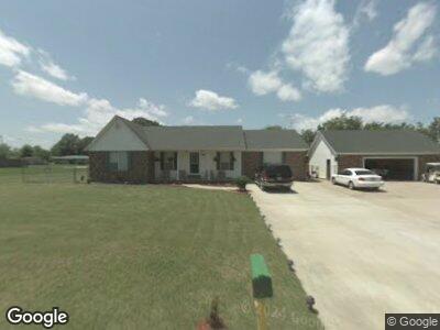
1011 Scott Dr Red Bay, AL 35582
Estimated Value: $106,000 - $183,915
3
Beds
--
Bath
2,112
Sq Ft
$71/Sq Ft
Est. Value
About This Home
This home is located at 1011 Scott Dr, Red Bay, AL 35582 and is currently estimated at $150,479, approximately $71 per square foot. 1011 Scott Dr is a home located in Franklin County.
Ownership History
Date
Name
Owned For
Owner Type
Purchase Details
Closed on
Dec 20, 2017
Sold by
Bostick Margoth
Bought by
Dora Gonzalez Jorge Tello and Dora Amelchor
Current Estimated Value
Home Financials for this Owner
Home Financials are based on the most recent Mortgage that was taken out on this home.
Original Mortgage
$69,490
Interest Rate
3.92%
Mortgage Type
New Conventional
Create a Home Valuation Report for This Property
The Home Valuation Report is an in-depth analysis detailing your home's value as well as a comparison with similar homes in the area
Home Values in the Area
Average Home Value in this Area
Purchase History
| Date | Buyer | Sale Price | Title Company |
|---|---|---|---|
| Dora Gonzalez Jorge Tello | -- | -- |
Source: Public Records
Mortgage History
| Date | Status | Borrower | Loan Amount |
|---|---|---|---|
| Open | Gonzalez Jorge Tello | $123,685 | |
| Closed | Gonzalez Jorge Tello | $163,969 | |
| Closed | Gonzalez Jorge Tello | $25,000 | |
| Closed | Dora Gonzalez Jorge Tello | $69,490 |
Source: Public Records
Tax History Compared to Growth
Tax History
| Year | Tax Paid | Tax Assessment Tax Assessment Total Assessment is a certain percentage of the fair market value that is determined by local assessors to be the total taxable value of land and additions on the property. | Land | Improvement |
|---|---|---|---|---|
| 2024 | $566 | $14,500 | $880 | $13,620 |
| 2023 | $566 | $13,760 | $840 | $12,920 |
| 2022 | $497 | $12,900 | $800 | $12,100 |
| 2021 | $467 | $12,200 | $800 | $11,400 |
| 2020 | $484 | $12,600 | $800 | $11,800 |
| 2019 | $484 | $25,140 | $1,520 | $23,620 |
| 2018 | $510 | $13,200 | $800 | $12,400 |
| 2017 | $441 | $11,600 | $800 | $10,800 |
| 2016 | $441 | $11,600 | $800 | $10,800 |
| 2015 | $441 | $11,600 | $800 | $10,800 |
| 2014 | $441 | $11,600 | $800 | $10,800 |
| 2013 | $428 | $11,300 | $800 | $10,500 |
Source: Public Records
Map
Nearby Homes
- 305 10th Ave NE
- 0 Hwy 23 Unit 24-3864
- 844 Hester Ave
- 729 10th Ave N
- 804 Liberty Ln
- 122 7th Ave SW
- 820 9th Ave
- 109 Whippoorwill Dr
- 115 Garrison Hollow Rd
- 0 Alabama 247
- 17 Drive in Rd
- 6 Cessna Dr
- 22 Shady Cove
- 100 Valley Rd
- 345 Mississippi 366
- 5 Pinehurst Dr
- 51 Main St
- 406 2nd St
- 404 2nd St
- 414 2nd St