Estimated Value: $612,669 - $693,000
4
Beds
3
Baths
2,176
Sq Ft
$298/Sq Ft
Est. Value
About This Home
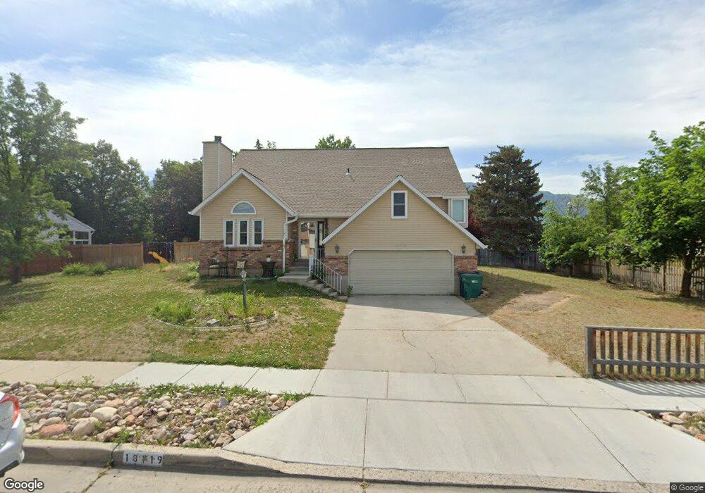
This home is located at 10119 Kimsbrough Rd, Sandy, UT 84092 and is currently estimated at $647,667, approximately $297 per square foot. 10119 Kimsbrough Rd is a home located in Salt Lake County with nearby schools including Willow Canyon Elementary School, Eastmont Middle School, and Jordan High.
Ownership History
Date
Name
Owned For
Owner Type
Purchase Details
Closed on
Dec 6, 1999
Sold by
Corbett Ronald J and Corbett Deborah R
Bought by
Osborne Tim D and Osborne Jennifer L
Current Estimated Value
Home Financials for this Owner
Home Financials are based on the most recent Mortgage that was taken out on this home.
Original Mortgage
$141,600
Outstanding Balance
$44,662
Interest Rate
7.96%
Estimated Equity
$603,005
Purchase Details
Closed on
Nov 23, 1993
Sold by
Corbett Ronald J and Corbett Deborah T
Bought by
Corbett Ronald J and Corbett Deborah R
Home Financials for this Owner
Home Financials are based on the most recent Mortgage that was taken out on this home.
Original Mortgage
$81,009
Interest Rate
6.74%
Mortgage Type
FHA
Create a Home Valuation Report for This Property
The Home Valuation Report is an in-depth analysis detailing your home's value as well as a comparison with similar homes in the area
Home Values in the Area
Average Home Value in this Area
Purchase History
| Date | Buyer | Sale Price | Title Company |
|---|---|---|---|
| Osborne Tim D | -- | Backman Stewart Title Servic | |
| Corbett Ronald J | -- | Guardian Title |
Source: Public Records
Mortgage History
| Date | Status | Borrower | Loan Amount |
|---|---|---|---|
| Open | Osborne Tim D | $141,600 | |
| Previous Owner | Corbett Ronald J | $81,009 |
Source: Public Records
Tax History
| Year | Tax Paid | Tax Assessment Tax Assessment Total Assessment is a certain percentage of the fair market value that is determined by local assessors to be the total taxable value of land and additions on the property. | Land | Improvement |
|---|---|---|---|---|
| 2025 | -- | $540,000 | $246,100 | $293,900 |
| 2024 | -- | $536,300 | $236,900 | $299,400 |
| 2023 | $2,561 | $490,100 | $227,800 | $262,300 |
| 2022 | $2,624 | $494,100 | $223,300 | $270,800 |
| 2021 | $2,515 | $403,600 | $178,600 | $225,000 |
| 2020 | $2,108 | $319,400 | $178,600 | $140,800 |
| 2019 | $2,060 | $304,800 | $168,500 | $136,300 |
| 2016 | $1,673 | $240,300 | $151,800 | $88,500 |
Source: Public Records
Map
Nearby Homes
- 10158 Buttercup Dr
- 10240 Locksley Rd
- 1650 E Budding Dr
- 1602 E Sego Lily Dr
- 9979 S Albury Rd
- 9971 Pinehurst Dr
- 10172 Snow Iris Way
- 10346 Wood Glen Cir
- 1420 E Firelight Way
- 1447 E Edgecliff Dr
- 9828 Pinehurst Dr
- 1563 E Tameron Dr
- 1584 Petunia Way
- 9968 S Blossom Dr
- 2009 E Sweetbriar Ln
- 1469 Winterwood Cir
- 9976 Tamara St E
- 10538 S Bay Meadow Dr
- 1952 E Bluffside Cir
- 10695 S Dielsdorf Rd
- 10138 Faunsdale Dr
- 10138 S Faunsdale Dr
- 10107 Kimsbrough Rd
- 11767 S 1700 E Unit 7
- 10128 S Faunsdale Dr
- 10128 Faunsdale Dr
- 10118 Kimsbrough Rd
- 10097 Kimsbrough Rd
- 10118 S Faunsdale Dr
- 10104 Kimsbrough Rd
- 10118 Faunsdale Dr
- 10140 Buttercup Dr
- 10132 Buttercup Dr
- 10132 S Buttercup Dr
- 10148 Buttercup Dr
- 10148 S Buttercup Dr
- 10122 Buttercup Dr
- 10099 Countrywood Dr
- 10143 Faunsdale Dr
- 10106 Faunsdale Dr
Your Personal Tour Guide
Ask me questions while you tour the home.