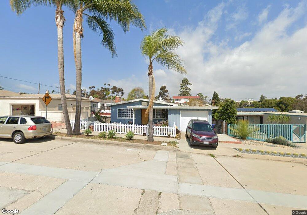
1012 W Walnut Ave San Diego, CA 92103
Middletown NeighborhoodEstimated Value: $1,084,000 - $1,465,000
2
Beds
1
Bath
936
Sq Ft
$1,335/Sq Ft
Est. Value
About This Home
This home is located at 1012 W Walnut Ave, San Diego, CA 92103 and is currently estimated at $1,249,330, approximately $1,334 per square foot. 1012 W Walnut Ave is a home located in San Diego County with nearby schools including Grant K-8, Richard Henry Dana Middle School, and Roosevelt International Middle School.
Ownership History
Date
Name
Owned For
Owner Type
Purchase Details
Closed on
Feb 24, 2009
Sold by
Zatt Mark
Bought by
Navarra Anthony G and Navarra Ninfa A
Current Estimated Value
Purchase Details
Closed on
Sep 30, 1997
Sold by
Hunt Dorothy F
Bought by
Hunt Dorothy F
Purchase Details
Closed on
Nov 24, 1993
Sold by
Hunt Dorothy F
Bought by
Hunt Dorothy F
Purchase Details
Closed on
Apr 8, 1985
Purchase Details
Closed on
Mar 19, 1984
Create a Home Valuation Report for This Property
The Home Valuation Report is an in-depth analysis detailing your home's value as well as a comparison with similar homes in the area
Home Values in the Area
Average Home Value in this Area
Purchase History
| Date | Buyer | Sale Price | Title Company |
|---|---|---|---|
| Navarra Anthony G | $415,000 | None Available | |
| Hunt Dorothy F | -- | First American Title Ins Co | |
| Hunt Dorothy F | -- | First American Title Ins Co | |
| Hunt Dorothy F | -- | -- | |
| -- | $150,000 | -- | |
| -- | $129,700 | -- |
Source: Public Records
Tax History Compared to Growth
Tax History
| Year | Tax Paid | Tax Assessment Tax Assessment Total Assessment is a certain percentage of the fair market value that is determined by local assessors to be the total taxable value of land and additions on the property. | Land | Improvement |
|---|---|---|---|---|
| 2025 | $6,468 | $534,275 | $386,321 | $147,954 |
| 2024 | $6,468 | $523,800 | $378,747 | $145,053 |
| 2023 | $6,325 | $513,530 | $371,321 | $142,209 |
| 2022 | $6,157 | $503,462 | $364,041 | $139,421 |
| 2021 | $6,115 | $493,591 | $356,903 | $136,688 |
| 2020 | $6,041 | $488,531 | $353,244 | $135,287 |
| 2019 | $5,934 | $478,953 | $346,318 | $132,635 |
| 2018 | $5,548 | $469,563 | $339,528 | $130,035 |
| 2017 | $5,416 | $460,357 | $332,871 | $127,486 |
| 2016 | $5,330 | $451,332 | $326,345 | $124,987 |
| 2015 | $5,251 | $444,553 | $321,443 | $123,110 |
| 2014 | $5,169 | $435,846 | $315,147 | $120,699 |
Source: Public Records
Map
Nearby Homes
- 3505 Ibis St
- 3448 Goldfinch St
- 3354 Hawk St
- 3635 Kite St
- 3467 Reynard Way Unit A
- 3320 Horton Ave
- 1235 1239 Lincoln Ave
- 3318-20 Union St
- 3206-16 Reynard Way
- 3109 Hawk St
- 3535 Columbia St
- 1570 Linwood St
- 3531 Columbia St
- 3460 Columbia St
- 3157 Harbor Ridge Ln Unit 2214
- 1617 Chalmers St
- 0 Bush St Unit (35-38) 240005385
- 3566 Albatross St
- 3243-45 Columbia St
- 301 W Brookes Ave