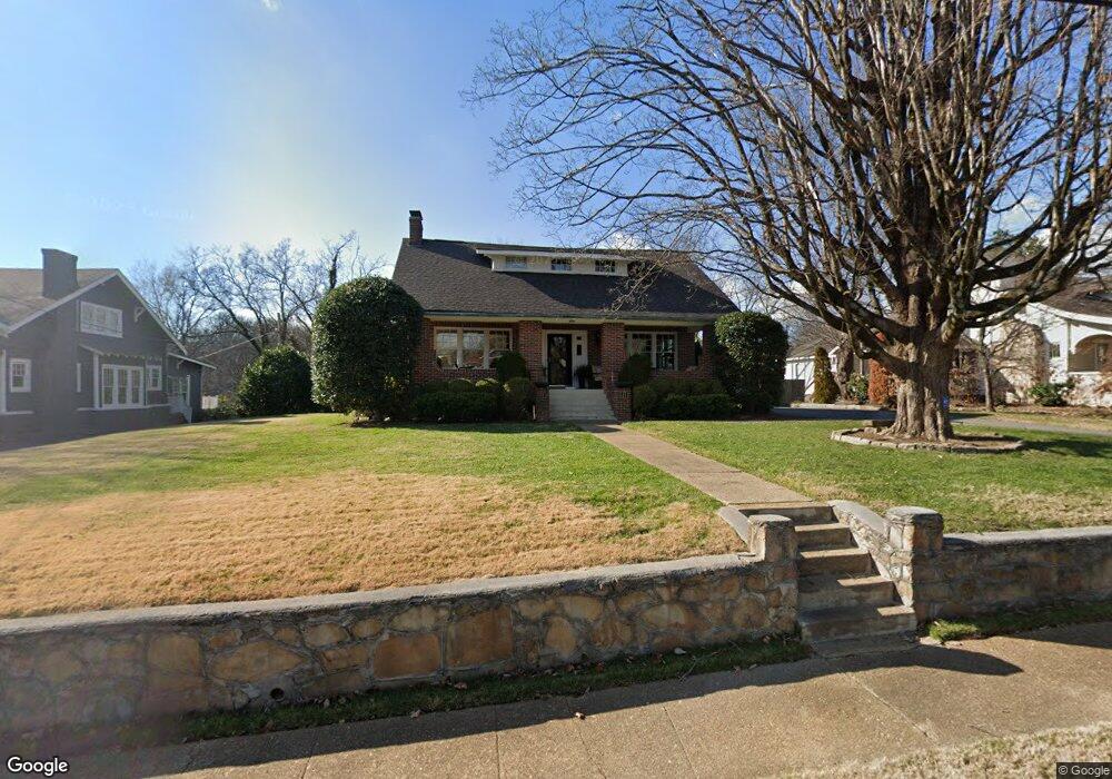
1012 Westwood Ave Chattanooga, TN 37405
North Chattanooga NeighborhoodEstimated Value: $706,000 - $1,148,111
5
Beds
3
Baths
3,102
Sq Ft
$320/Sq Ft
Est. Value
About This Home
This home is located at 1012 Westwood Ave, Chattanooga, TN 37405 and is currently estimated at $994,028, approximately $320 per square foot. 1012 Westwood Ave is a home located in Hamilton County with nearby schools including Normal Park Museum Magnet School, Red Bank High School, and The Bright School.
Ownership History
Date
Name
Owned For
Owner Type
Purchase Details
Closed on
May 22, 2002
Sold by
Carter Blair W
Bought by
Rutledge Christopher M and Rutledge Rachel A
Current Estimated Value
Home Financials for this Owner
Home Financials are based on the most recent Mortgage that was taken out on this home.
Original Mortgage
$150,000
Outstanding Balance
$63,562
Interest Rate
6.98%
Mortgage Type
Purchase Money Mortgage
Estimated Equity
$930,466
Purchase Details
Closed on
Jul 31, 1995
Bought by
Carter Blair W
Purchase Details
Closed on
Jul 1, 1995
Sold by
Carter Janis M
Bought by
Carter Blair W
Create a Home Valuation Report for This Property
The Home Valuation Report is an in-depth analysis detailing your home's value as well as a comparison with similar homes in the area
Home Values in the Area
Average Home Value in this Area
Purchase History
| Date | Buyer | Sale Price | Title Company |
|---|---|---|---|
| Rutledge Christopher M | $240,000 | -- | |
| Carter Blair W | -- | -- | |
| Carter Blair W | -- | -- |
Source: Public Records
Mortgage History
| Date | Status | Borrower | Loan Amount |
|---|---|---|---|
| Open | Rutledge Christopher M | $150,000 |
Source: Public Records
Tax History Compared to Growth
Tax History
| Year | Tax Paid | Tax Assessment Tax Assessment Total Assessment is a certain percentage of the fair market value that is determined by local assessors to be the total taxable value of land and additions on the property. | Land | Improvement |
|---|---|---|---|---|
| 2024 | $3,261 | $145,750 | $0 | $0 |
| 2023 | $3,261 | $145,750 | $0 | $0 |
| 2022 | $3,261 | $145,750 | $0 | $0 |
| 2021 | $3,261 | $145,750 | $0 | $0 |
| 2020 | $3,044 | $110,075 | $0 | $0 |
| 2019 | $3,044 | $110,075 | $0 | $0 |
| 2018 | $2,633 | $110,075 | $0 | $0 |
| 2017 | $3,044 | $110,075 | $0 | $0 |
| 2016 | $2,439 | $0 | $0 | $0 |
| 2015 | $4,591 | $88,200 | $0 | $0 |
| 2014 | $4,591 | $0 | $0 | $0 |
Source: Public Records
Map
Nearby Homes
- 1000 Westwood Ave
- 1704 Knickerbocker Ave
- 1014 Englewood Ave
- 917 Dartmouth St
- 1814 Knickerbocker Ave
- 1012 Dartmouth St
- 1104 Westwood Ave
- 900 Avon Place
- 1016 Englewood Ave
- 1118 Englewood Ave
- 834 Dartmouth St
- 1877 Notting Hill
- 1259 Duane Rd
- 914 Mount Vernon Ave
- 1853 Notting Hill
- 1301 Shady Cir
- 1015 Mount Vernon Ave
- 1340 Carrington Way
- 773 Curve St
- 719 Federal St
- 1014 Westwood Ave
- 1008 Westwood Ave
- 1606 Knickerbocker Ave
- 1600 Knickerbocker Ave
- 1018 Westwood Ave
- 1004 Westwood Ave
- 2452 Highland Dr
- 1001 Dartmouth St
- 1007 Westwood Ave
- 1612 Knickerbocker Ave
- 1009 Westwood Ave
- 1003 Dartmouth St
- 1005 Westwood Ave
- 1005 Dartmouth St Unit 46
- 1005 Dartmouth St
- 1005 Darmouth St
- 1022 Westwood Ave
- 1261 Highland Dr
- 1700 Knickerbocker Ave
- 1002 Westwood Ave