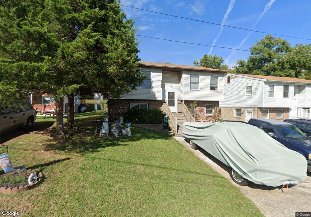
10120 High Ridge Rd Laurel, MD 20723
North Laurel NeighborhoodEstimated Value: $404,307 - $531,000
--
Bed
2
Baths
1,076
Sq Ft
$445/Sq Ft
Est. Value
About This Home
This home is located at 10120 High Ridge Rd, Laurel, MD 20723 and is currently estimated at $479,077, approximately $445 per square foot. 10120 High Ridge Rd is a home located in Howard County with nearby schools including Gorman Crossing Elementary School, Hammond Middle School, and Reservoir High School.
Ownership History
Date
Name
Owned For
Owner Type
Purchase Details
Closed on
Jan 12, 1990
Sold by
Weddle Jerry I
Bought by
Crawford Jeffrey Lee
Current Estimated Value
Home Financials for this Owner
Home Financials are based on the most recent Mortgage that was taken out on this home.
Original Mortgage
$123,450
Interest Rate
9.8%
Purchase Details
Closed on
Dec 26, 1988
Sold by
Eileen L Sentell
Bought by
Weddle Jerry I
Create a Home Valuation Report for This Property
The Home Valuation Report is an in-depth analysis detailing your home's value as well as a comparison with similar homes in the area
Home Values in the Area
Average Home Value in this Area
Purchase History
| Date | Buyer | Sale Price | Title Company |
|---|---|---|---|
| Crawford Jeffrey Lee | $130,000 | -- | |
| Weddle Jerry I | $54,000 | -- |
Source: Public Records
Mortgage History
| Date | Status | Borrower | Loan Amount |
|---|---|---|---|
| Closed | Crawford Jeffrey Lee | $123,450 |
Source: Public Records
Tax History Compared to Growth
Tax History
| Year | Tax Paid | Tax Assessment Tax Assessment Total Assessment is a certain percentage of the fair market value that is determined by local assessors to be the total taxable value of land and additions on the property. | Land | Improvement |
|---|---|---|---|---|
| 2025 | $5,679 | $369,800 | $166,200 | $203,600 |
| 2024 | $5,679 | $360,033 | $0 | $0 |
| 2023 | $5,443 | $350,267 | $0 | $0 |
| 2022 | $5,263 | $340,500 | $171,200 | $169,300 |
| 2021 | $2,733 | $318,000 | $0 | $0 |
| 2020 | $4,616 | $295,500 | $0 | $0 |
| 2019 | $3,937 | $273,000 | $110,800 | $162,200 |
| 2018 | $3,929 | $265,733 | $0 | $0 |
| 2017 | $3,829 | $273,000 | $0 | $0 |
| 2016 | -- | $251,200 | $0 | $0 |
| 2015 | -- | $251,200 | $0 | $0 |
| 2014 | -- | $251,200 | $0 | $0 |
Source: Public Records
Map
Nearby Homes
- 9256 Laurens Way
- 9260 Old Scaggsville Rd
- 9420 Fairview Ave
- 9422 Fairview Ave
- 211 Patuxent Rd
- 7709 Brooklyn Bridge Rd
- 200 1/2 11th St
- 9401 Riverbrink Ct
- 1103 Montgomery St
- 9351 Cabot Ct
- 1106 Snowden Place
- 1210 Westview Terrace
- 9786 Whiskey Run
- 7616 Woodbine Dr
- 7209 Brooklyn Bridge Rd
- Dorchester IV Plan at Cole's Manor
- Tidewater Plan at Cole's Manor
- Stratton Plan at Cole's Manor
- Adrienne's Honneur II Plan at Cole's Manor
- Mount Vernon IV Villa 2 Plan at Cole's Manor
- 10124 High Ridge Rd
- 10118 High Ridge Rd
- 10126 High Ridge Rd
- 10128 High Ridge Rd
- 4 LOT High Ridge Rd
- 3 LOT High Ridge Rd
- 10114 High Ridge Rd
- 10136 High Ridge Rd
- LOT 2 High Ridge Rd
- 10132 High Ridge Rd
- 10119 High Ridge Rd
- 10110 High Ridge Rd
- 10118 Wilnor Way
- 9944 Twin Fawn Trail
- 10114 Wilnor Way
- 10121 High Ridge Rd
- 10110 Wilnor Way
- 10108 High Ridge Rd
- 9940 Twin Fawn Trail
- 9180 Old Scaggsville Rd