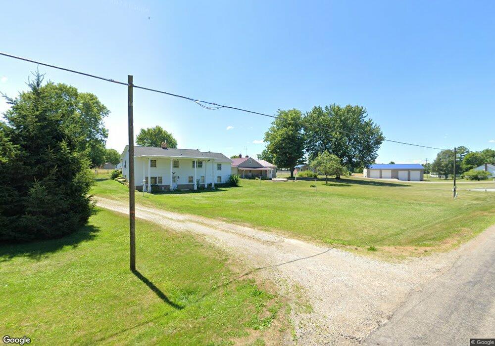
1013 County Road 1175 Ashland, OH 44805
Estimated Value: $151,533 - $197,000
2
Beds
1
Bath
1,028
Sq Ft
$162/Sq Ft
Est. Value
About This Home
This home is located at 1013 County Road 1175, Ashland, OH 44805 and is currently estimated at $166,883, approximately $162 per square foot. 1013 County Road 1175 is a home located in Ashland County with nearby schools including Mapleton Elementary School, Mapleton Middle School, and Mapleton High School.
Ownership History
Date
Name
Owned For
Owner Type
Purchase Details
Closed on
Mar 18, 2025
Sold by
Karper Family Trust and Karper Anthony Wayne
Bought by
Kip Nankin Llc
Current Estimated Value
Purchase Details
Closed on
May 2, 2014
Sold by
Baker Lyle E
Bought by
Karper Anthony Wayne Te and Karper Janet Leete
Purchase Details
Closed on
Jul 2, 2007
Sold by
Baker Lyle E
Bought by
Baker Lyle E
Purchase Details
Closed on
Jun 15, 2007
Sold by
Baker Lyle E
Bought by
Baker Lyle E
Purchase Details
Closed on
Jan 1, 1990
Bought by
Baker Lyle E
Create a Home Valuation Report for This Property
The Home Valuation Report is an in-depth analysis detailing your home's value as well as a comparison with similar homes in the area
Home Values in the Area
Average Home Value in this Area
Purchase History
| Date | Buyer | Sale Price | Title Company |
|---|---|---|---|
| Kip Nankin Llc | -- | Heartland Title | |
| Kip Nankin Llc | -- | Heartland Title | |
| Karper Anthony Wayne Te | $67,000 | Attorney Only | |
| Baker Lyle E | -- | -- | |
| Baker Lyle E | -- | -- | |
| Baker Lyle E | -- | -- |
Source: Public Records
Tax History Compared to Growth
Tax History
| Year | Tax Paid | Tax Assessment Tax Assessment Total Assessment is a certain percentage of the fair market value that is determined by local assessors to be the total taxable value of land and additions on the property. | Land | Improvement |
|---|---|---|---|---|
| 2024 | $1,357 | $40,070 | $6,630 | $33,440 |
| 2023 | $1,357 | $40,070 | $6,630 | $33,440 |
| 2022 | $1,220 | $32,050 | $5,300 | $26,750 |
| 2021 | $928 | $26,140 | $5,300 | $20,840 |
| 2020 | $928 | $26,140 | $5,300 | $20,840 |
| 2019 | $825 | $22,560 | $5,260 | $17,300 |
| 2018 | $866 | $22,560 | $5,260 | $17,300 |
| 2017 | $875 | $22,560 | $5,260 | $17,300 |
| 2016 | $791 | $20,510 | $4,780 | $15,730 |
| 2015 | $762 | $20,510 | $4,780 | $15,730 |
| 2013 | $525 | $22,660 | $4,760 | $17,900 |
Source: Public Records
Map
Nearby Homes
- 900 County Road 801
- 885 State Route 58
- 1173 Township Road 753
- 829 County Road 801
- 99 Harold Dr
- 95 Harold Dr
- 32 Terrace Dr
- 16 Terrace Dr
- 67 Harold Dr
- 3 Terrace Dr
- 1520 Orange Rd Unit 22
- 1520 Orange Rd
- 1191 State Route 511
- 1438 Peachtree Dr
- 0 Westlake Dr
- 1471 Troy Rd
- 945 Virginia Ave
- 686 County Road 1302
- 410 E 9th St
- 634 Marlo Ave
- 1011 County Road 1175
- 1015 County Road 1175
- 1009 County Road 1175
- 1012 County Road 1175
- 1014B Ohio 58
- 1014 State Route 58
- 1014 State Route 58 Unit B
- 1014 State Route 58
- 1007 County Road 1175
- 1019 County Road 1175
- 1014 Ohio 58
- 1010 County Road 1175
- 1006 State Route 58
- 1016 County Road 1175
- 1006 Ohio 58
- 1006 County Road 1175
- 1005 County Road 1175
- 1003 County Road 1175
- 1025 County Road 1175
- 1002 County Road 1175