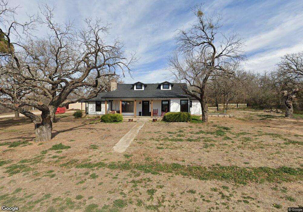
1013 Holbrook Rd Springtown, TX 76082
Estimated Value: $363,635 - $393,000
3
Beds
3
Baths
2,273
Sq Ft
$167/Sq Ft
Est. Value
About This Home
This home is located at 1013 Holbrook Rd, Springtown, TX 76082 and is currently estimated at $378,545, approximately $166 per square foot. 1013 Holbrook Rd is a home located in Parker County with nearby schools including Goshen Creek Elementary School, Springtown Middle School, and Springtown Intermediate School.
Ownership History
Date
Name
Owned For
Owner Type
Purchase Details
Closed on
Apr 22, 2022
Sold by
Leon Lunsford Floyd and Kaye Paula
Bought by
Alfred Aaron and Alfred Tara
Current Estimated Value
Purchase Details
Closed on
May 22, 2015
Sold by
Stoker Patrick Glen and Stoker Nancy Lynne
Bought by
Mallory Daniel Reece and Mallory Daniel
Home Financials for this Owner
Home Financials are based on the most recent Mortgage that was taken out on this home.
Original Mortgage
$80,000
Interest Rate
3.68%
Mortgage Type
Seller Take Back
Purchase Details
Closed on
Dec 4, 2014
Sold by
Pennington Christopher Paul and Pennington Jennifer A
Bought by
Lunsford Floyd Leon and Lunsford Paula Kaye
Home Financials for this Owner
Home Financials are based on the most recent Mortgage that was taken out on this home.
Original Mortgage
$131,250
Interest Rate
3.93%
Mortgage Type
Purchase Money Mortgage
Purchase Details
Closed on
Jul 15, 2005
Sold by
Stoker Patrick Glen and Stoker Nancy Lynne
Bought by
Pennington Christopher Paul and Pennington Jennifer A
Home Financials for this Owner
Home Financials are based on the most recent Mortgage that was taken out on this home.
Original Mortgage
$116,400
Interest Rate
5.64%
Mortgage Type
New Conventional
Purchase Details
Closed on
Jul 7, 2005
Sold by
Stoker Patrick G and Stoker Nancy L
Bought by
Lunsford Floyd Leon and Paula Kaye
Home Financials for this Owner
Home Financials are based on the most recent Mortgage that was taken out on this home.
Original Mortgage
$116,400
Interest Rate
5.64%
Mortgage Type
New Conventional
Purchase Details
Closed on
Apr 22, 1996
Bought by
Lunsford Floyd Leon and Paula Kaye
Purchase Details
Closed on
Jan 1, 1901
Bought by
Lunsford Floyd Leon and Paula Kaye
Create a Home Valuation Report for This Property
The Home Valuation Report is an in-depth analysis detailing your home's value as well as a comparison with similar homes in the area
Home Values in the Area
Average Home Value in this Area
Purchase History
| Date | Buyer | Sale Price | Title Company |
|---|---|---|---|
| Alfred Aaron | -- | Fidelity National Title | |
| Mallory Daniel Reece | -- | Dhi | |
| Lunsford Floyd Leon | -- | Dhi | |
| Pennington Christopher Paul | -- | None Available | |
| Lunsford Floyd Leon | -- | -- | |
| Pennington Christopher Paul | -- | None Available | |
| Lunsford Floyd Leon | -- | -- | |
| Lunsford Floyd Leon | -- | -- |
Source: Public Records
Mortgage History
| Date | Status | Borrower | Loan Amount |
|---|---|---|---|
| Previous Owner | Mallory Daniel Reece | $80,000 | |
| Previous Owner | Lunsford Floyd Leon | $131,250 | |
| Previous Owner | Pennington Christopher Paul | $116,400 | |
| Previous Owner | Pennington Christopher Paul | $116,400 | |
| Previous Owner | Lunsford Floyd Leon | $15,000 |
Source: Public Records
Tax History
| Year | Tax Paid | Tax Assessment Tax Assessment Total Assessment is a certain percentage of the fair market value that is determined by local assessors to be the total taxable value of land and additions on the property. | Land | Improvement |
|---|---|---|---|---|
| 2025 | $5,180 | $330,210 | $55,000 | $275,210 |
| 2024 | $5,180 | $334,140 | $85,000 | $249,140 |
| 2023 | $5,180 | $334,140 | $85,000 | $249,140 |
| 2022 | $3,395 | $190,390 | $20,000 | $170,390 |
| 2021 | $3,685 | $190,390 | $20,000 | $170,390 |
| 2020 | $2,974 | $154,140 | $15,000 | $139,140 |
| 2019 | $3,197 | $154,140 | $15,000 | $139,140 |
| 2018 | $2,616 | $125,770 | $15,000 | $110,770 |
| 2017 | $2,741 | $125,770 | $15,000 | $110,770 |
| 2016 | $2,728 | $125,140 | $15,000 | $110,140 |
| 2015 | $2,691 | $125,140 | $15,000 | $110,140 |
| 2014 | -- | $125,400 | $15,000 | $110,400 |
Source: Public Records
Map
Nearby Homes
- 3120 Holbrook Rd
- 00 Hutcheson Hill
- 801 Taliaferro Trail
- 3837 Holbrook Rd
- 825 Holbrook Rd
- 804 Feather Edge Dr
- 1325 Frio Dr
- 1329 Frio Dr
- 1092 W Highway 199
- 160 Summit Dr
- 650 Winkler Way
- 664 Winkler Way
- 501 Lazy b Ln
- 314 W 5th St
- TBD W 5th St
- 309 N Cedar St
- 703 Winkler Way
- 624 Winkler Way
- 1035 Summit Dr
- 604 Goshen Rd
- 211 Oak Ct
- 200 Oak Ct
- 1125 Holbrook Rd
- 151 Oak Ct
- 150 Oak Ct
- 110 Pojo Dr
- 1351 Holbrook Rd
- 1302 Holbrook Rd
- 1399 Holbrook Rd
- 1403 Holbrook Rd
- 573 Po jo Dr
- 555 Po jo Dr
- 1360 Holbrook Rd
- 1421 Holbrook Rd
- 1398 Holbrook Rd
- 204 Oak Hill St
- 1420 Holbrook Rd
- 817 Taliaferro Trail
- 813 Taliaferro Trail
- 809 Taliaferro Trail
Your Personal Tour Guide
Ask me questions while you tour the home.