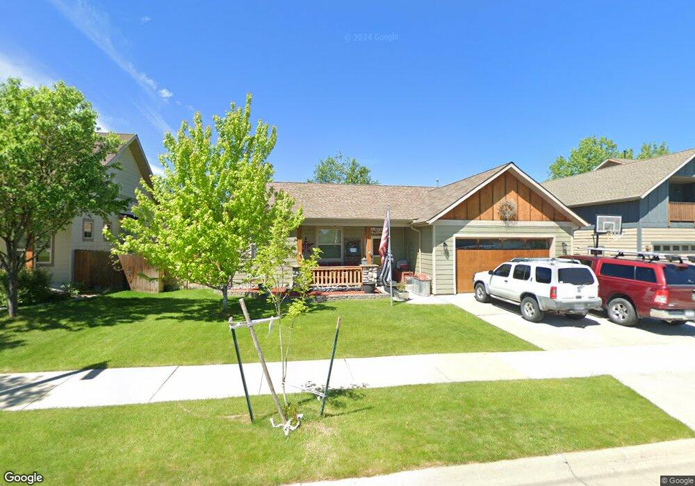
1013 Springbrook Ave Bozeman, MT 59718
Harvest Creek NeighborhoodEstimated Value: $642,508 - $679,000
3
Beds
2
Baths
1,686
Sq Ft
$394/Sq Ft
Est. Value
About This Home
This home is located at 1013 Springbrook Ave, Bozeman, MT 59718 and is currently estimated at $663,877, approximately $393 per square foot. 1013 Springbrook Ave is a home located in Gallatin County with nearby schools including Emily Dickinson School, Chief Joseph Middle School, and Gallatin High School.
Ownership History
Date
Name
Owned For
Owner Type
Purchase Details
Closed on
Oct 11, 2011
Sold by
Carrico Jason and Carrico Molly
Bought by
Jones Sara Gene
Current Estimated Value
Home Financials for this Owner
Home Financials are based on the most recent Mortgage that was taken out on this home.
Original Mortgage
$213,750
Outstanding Balance
$145,068
Interest Rate
4.15%
Mortgage Type
New Conventional
Estimated Equity
$518,809
Purchase Details
Closed on
Dec 19, 2005
Sold by
Bridger Montana Investments Llc
Bought by
Carrico Jason and Carrico Molly
Home Financials for this Owner
Home Financials are based on the most recent Mortgage that was taken out on this home.
Original Mortgage
$241,466
Interest Rate
5.75%
Mortgage Type
Fannie Mae Freddie Mac
Create a Home Valuation Report for This Property
The Home Valuation Report is an in-depth analysis detailing your home's value as well as a comparison with similar homes in the area
Home Values in the Area
Average Home Value in this Area
Purchase History
| Date | Buyer | Sale Price | Title Company |
|---|---|---|---|
| Jones Sara Gene | -- | Security Title Company | |
| Carrico Jason | -- | Security Title Company |
Source: Public Records
Mortgage History
| Date | Status | Borrower | Loan Amount |
|---|---|---|---|
| Open | Jones Sara Gene | $213,750 | |
| Previous Owner | Carrico Jason | $241,466 |
Source: Public Records
Tax History
| Year | Tax Paid | Tax Assessment Tax Assessment Total Assessment is a certain percentage of the fair market value that is determined by local assessors to be the total taxable value of land and additions on the property. | Land | Improvement |
|---|---|---|---|---|
| 2025 | $3,233 | $699,600 | $0 | $0 |
| 2024 | $4,498 | $675,700 | $0 | $0 |
| 2023 | $4,352 | $675,700 | $0 | $0 |
| 2022 | $3,310 | $431,600 | $0 | $0 |
| 2021 | $3,652 | $431,600 | $0 | $0 |
| 2020 | $3,202 | $374,700 | $0 | $0 |
| 2019 | $3,275 | $374,700 | $0 | $0 |
| 2018 | $2,964 | $314,200 | $0 | $0 |
| 2017 | $2,771 | $314,200 | $0 | $0 |
| 2016 | $2,587 | $274,000 | $0 | $0 |
| 2015 | $2,583 | $274,000 | $0 | $0 |
| 2014 | $2,367 | $148,082 | $0 | $0 |
Source: Public Records
Map
Nearby Homes
- 3263 Annie St
- 1372 Zephyr Way
- 3108 Oliver St
- 8 N Eldorado Ave
- 357 Swayback Ln
- 330 Swayback Ln
- 111 White Horse Loop
- 887 Hanson St
- 3598 Annie St
- 988 Meagher Ave
- 720 N Sheridan Ave
- 560 Christopher Way
- 3035 Breeze Ln Unit B
- 3055 Breeze Ln Unit B
- 515 Michael Grove Ave Unit 60
- 515 Michael Grove Ave Unit 42
- 1640 New Holland Dr Unit A
- 488 Meriwether Ave
- 454 Meriwether Ave
- 1140 N 27th Ave Unit 2
- 983 Springbrook Ave
- 1014 Harmon Way
- 970 Harmon Way
- 965 Springbrook Ave
- 1051 Springbrook Ave
- 958 Harmon Way
- 949 Springbrook Ave
- 1079 Springbrook Ave
- 934 Harmon Way
- Lot 12 Harmon Way
- 1036 Harmon Way
- TBD Harmon Way
- 1009 Harmon Way
- 1072 Harmon Way
- 985 Harmon Way
- 1021 Harmon Way
- 1043 Harmon Way
- 963 Harmon Way
- 1093 Springbrook Ave
- 1094 Harmon Way
Your Personal Tour Guide
Ask me questions while you tour the home.