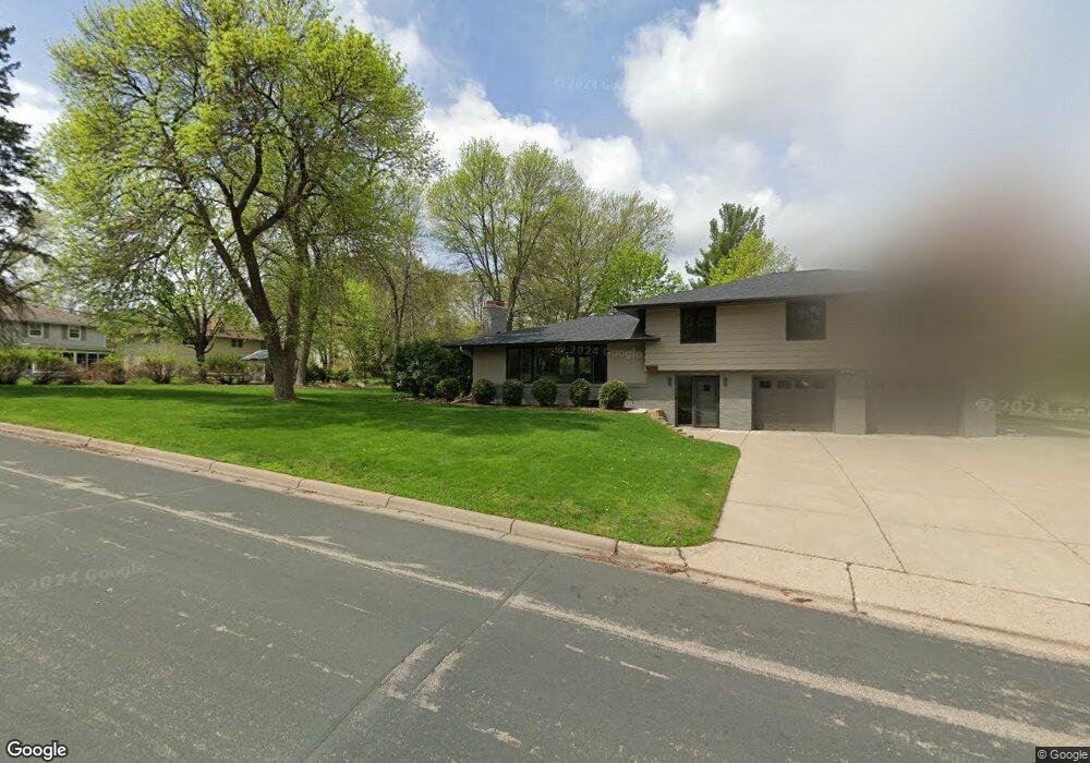
10132 Beard Ave S Minneapolis, MN 55431
West Bloomington NeighborhoodEstimated Value: $444,713 - $514,000
5
Beds
3
Baths
2,545
Sq Ft
$192/Sq Ft
Est. Value
About This Home
This home is located at 10132 Beard Ave S, Minneapolis, MN 55431 and is currently estimated at $487,428, approximately $191 per square foot. 10132 Beard Ave S is a home located in Hennepin County with nearby schools including Olson Elementary School, Olson Middle School, and Jefferson Senior High School.
Ownership History
Date
Name
Owned For
Owner Type
Purchase Details
Closed on
Jul 10, 2015
Sold by
Gale Stuart Warren and Leonard Sharon Gale
Bought by
Hunt James Brian
Current Estimated Value
Home Financials for this Owner
Home Financials are based on the most recent Mortgage that was taken out on this home.
Original Mortgage
$248,000
Outstanding Balance
$194,651
Interest Rate
4.05%
Mortgage Type
New Conventional
Estimated Equity
$292,777
Create a Home Valuation Report for This Property
The Home Valuation Report is an in-depth analysis detailing your home's value as well as a comparison with similar homes in the area
Home Values in the Area
Average Home Value in this Area
Purchase History
| Date | Buyer | Sale Price | Title Company |
|---|---|---|---|
| Hunt James Brian | $310,000 | First American Title Ins Co |
Source: Public Records
Mortgage History
| Date | Status | Borrower | Loan Amount |
|---|---|---|---|
| Open | Hunt James Brian | $248,000 |
Source: Public Records
Tax History Compared to Growth
Tax History
| Year | Tax Paid | Tax Assessment Tax Assessment Total Assessment is a certain percentage of the fair market value that is determined by local assessors to be the total taxable value of land and additions on the property. | Land | Improvement |
|---|---|---|---|---|
| 2024 | $5,099 | $401,100 | $139,700 | $261,400 |
| 2023 | $4,993 | $414,000 | $141,100 | $272,900 |
| 2022 | $4,448 | $398,100 | $141,100 | $257,000 |
| 2021 | $4,018 | $351,000 | $131,800 | $219,200 |
| 2020 | $4,433 | $322,700 | $128,100 | $194,600 |
| 2019 | $3,878 | $343,800 | $128,100 | $215,700 |
| 2018 | $3,713 | $299,100 | $127,500 | $171,600 |
| 2017 | $3,301 | $254,400 | $114,400 | $140,000 |
| 2016 | $3,419 | $237,300 | $106,900 | $130,400 |
| 2015 | $3,162 | $225,600 | $103,700 | $121,900 |
| 2014 | -- | $213,200 | $100,600 | $112,600 |
Source: Public Records
Map
Nearby Homes
- 3600 W 102nd St
- 10212 Xerxes Ave S
- 10241 Washburn Cir S
- 3801 W 98th St Unit 402
- 10449 Xerxes Ave S
- 9917 Brookside Cir
- 4301 Heritage Hills Dr
- 2801 W Old Shakopee Rd
- 10004 Maple Cir
- 10516 Upton Cir S
- 4708 W 102nd St
- 4653 Heritage Hills Cir
- 10627 Thomas Ave S
- 10624 Sheridan Ave S
- 2225 Village Terrace
- 2113 Village Terrace
- 10616 Johnson Rd
- 10809 Upton Ave S
- 10243 Scarborough Rd
- 10940 Chowen Ave S
- 3520 Beard Curve
- 10148 Beard Ave S
- 10133 Beard Ave S
- 3518 Beard Curve
- 3508 W 102nd St
- 10141 Beard Ave S
- 10125 Beard Ave S
- 10116 Beard Ave S
- 3516 W 102nd St
- 3511 Beard Curve
- 3630 W 102nd St
- 3636 W 102nd St
- 3416 W 102nd St
- 10117 Beard Ave S
- 3516 Beard Curve
- 3509 Beard Curve
- 3702 W 102nd St
- 3408 W 102nd St
- 3714 W 102nd St
- 3720 W 102nd St