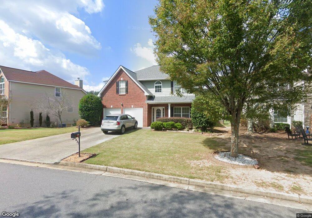
1015 Brushfoot Trail Suwanee, GA 30024
Estimated Value: $547,000 - $604,000
4
Beds
3
Baths
2,922
Sq Ft
$197/Sq Ft
Est. Value
About This Home
This home is located at 1015 Brushfoot Trail, Suwanee, GA 30024 and is currently estimated at $574,411, approximately $196 per square foot. 1015 Brushfoot Trail is a home located in Forsyth County with nearby schools including Settles Bridge Elementary School, Riverwatch Middle School, and Lambert High School.
Ownership History
Date
Name
Owned For
Owner Type
Purchase Details
Closed on
Aug 16, 2021
Sold by
Chu Ben
Bought by
Zhu Benchu
Current Estimated Value
Purchase Details
Closed on
May 13, 2011
Sold by
Zheng Mei Z
Bought by
Zhu Ben C
Purchase Details
Closed on
Mar 27, 2009
Sold by
Zhu Ben C
Bought by
Zhu Ben C and Zheng Mei
Home Financials for this Owner
Home Financials are based on the most recent Mortgage that was taken out on this home.
Original Mortgage
$130,000
Interest Rate
5.1%
Mortgage Type
New Conventional
Create a Home Valuation Report for This Property
The Home Valuation Report is an in-depth analysis detailing your home's value as well as a comparison with similar homes in the area
Home Values in the Area
Average Home Value in this Area
Purchase History
| Date | Buyer | Sale Price | Title Company |
|---|---|---|---|
| Zhu Benchu | -- | -- | |
| Zhu Ben C | -- | -- | |
| Zhu Ben C | -- | -- | |
| Zhu Ben C | $220,000 | -- |
Source: Public Records
Mortgage History
| Date | Status | Borrower | Loan Amount |
|---|---|---|---|
| Previous Owner | Zhu Ben C | $130,000 |
Source: Public Records
Tax History
| Year | Tax Paid | Tax Assessment Tax Assessment Total Assessment is a certain percentage of the fair market value that is determined by local assessors to be the total taxable value of land and additions on the property. | Land | Improvement |
|---|---|---|---|---|
| 2025 | $5,078 | $219,796 | $80,000 | $139,796 |
| 2024 | $5,078 | $207,080 | $66,000 | $141,080 |
| 2023 | $4,633 | $188,236 | $54,000 | $134,236 |
Source: Public Records
Map
Nearby Homes
- 1425 Buckskin Trail
- 715 Moonlight Way
- 451 Nichols Dr
- 310 Burgess Mill Trail
- 561 Nichols Rd
- 195 Woodcliff Ct
- 1445 Thunder Gulch Pass
- 1870 Apollo Dr
- 245 Mayfair Ct
- 740 Mayfair Ct
- 1750 Cone Flower Way
- 1680 Cone Flower Way
- 1820 Turnberry Ave
- 3270 Sydenham Ct
- 105 Grand Ave
- 3990 Sweeting St
- 50 Lakecrest Cir
- 86 Grand Ave
- 870 Earlham Dr
- 4795 Cold Spring Ct
- 1025 Brushfoot Trail
- 1010 Red Cedar Trail
- 1010 Brushfoot Trail
- 1035 Brushfoot Trail
- 1020 Red Cedar Trail
- 1260 Mount Laurel Place
- 1015 Red Cedar Trail
- 1045 Brushfoot Trail
- 1030 Red Cedar Trail
- 1250 Mount Laurel Place
- 1270 Mount Laurel Place
- 1025 Red Cedar Trail
- 1240 Mount Laurel Place
- 1040 1040 Red Cedar Trail
- 1040 Red Cedar Trail
- 1055 Brushfoot Trail
- 1265 Mount Laurel Place
- 1035 Red Cedar Trail
- 1115 Goldenrod Ln
- 1245 Mount Laurel Place
Your Personal Tour Guide
Ask me questions while you tour the home.