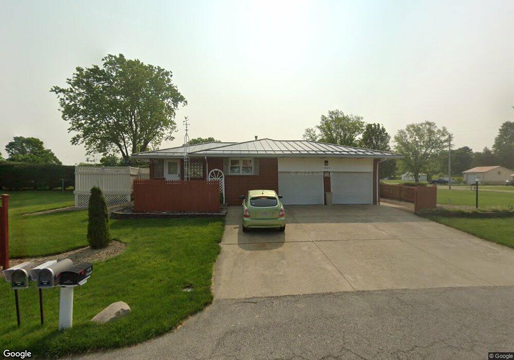
1015 Freeway Cir Mansfield, OH 44903
Estimated Value: $230,000 - $249,000
3
Beds
2
Baths
1,726
Sq Ft
$138/Sq Ft
Est. Value
About This Home
This home is located at 1015 Freeway Cir, Mansfield, OH 44903 and is currently estimated at $238,982, approximately $138 per square foot. 1015 Freeway Cir is a home located in Richland County with nearby schools including Madison High School, St. Peter's Elementary/Montessori School, and St. Peter's Junior High / High School.
Ownership History
Date
Name
Owned For
Owner Type
Purchase Details
Closed on
Mar 2, 1992
Sold by
Parrella Jerry
Bought by
Parrella Jerry
Current Estimated Value
Create a Home Valuation Report for This Property
The Home Valuation Report is an in-depth analysis detailing your home's value as well as a comparison with similar homes in the area
Home Values in the Area
Average Home Value in this Area
Purchase History
| Date | Buyer | Sale Price | Title Company |
|---|---|---|---|
| Parrella Jerry | -- | -- |
Source: Public Records
Tax History
| Year | Tax Paid | Tax Assessment Tax Assessment Total Assessment is a certain percentage of the fair market value that is determined by local assessors to be the total taxable value of land and additions on the property. | Land | Improvement |
|---|---|---|---|---|
| 2024 | $2,312 | $53,890 | $8,650 | $45,240 |
| 2023 | $2,365 | $53,890 | $8,650 | $45,240 |
| 2022 | $2,198 | $44,710 | $8,070 | $36,640 |
| 2021 | $2,229 | $44,710 | $8,070 | $36,640 |
| 2020 | $2,100 | $44,710 | $8,070 | $36,640 |
| 2019 | $1,980 | $37,890 | $6,840 | $31,050 |
| 2018 | $1,961 | $37,890 | $6,840 | $31,050 |
| 2017 | $1,923 | $37,890 | $6,840 | $31,050 |
| 2016 | $2,030 | $38,880 | $6,630 | $32,250 |
| 2015 | $1,916 | $38,880 | $6,630 | $32,250 |
| 2014 | $1,909 | $38,880 | $6,630 | $32,250 |
| 2012 | $890 | $40,080 | $6,840 | $33,240 |
Source: Public Records
Map
Nearby Homes
- 1715 Mansfield Lucas Rd
- 0 Woodville Rd Unit Lot 14952, 14953
- 0 Woodville Rd Unit Lot 14954, 14955
- 0 Woodville Rd Unit Lot 14956, 14957,
- 2420 Mansfield Washington Rd
- 794 Mansfield Washington Rd
- 0 State Route 39 & I-71 Southeast Quadrant
- 0 State Route 39 & I-71 Northeast Quadrant
- 716 Mansfield Washington Rd
- 1599 S Main St
- 50 Lilac Ct E
- 65 Logan Rd
- 537 Woodville Rd
- 1851 State Route 39
- 33 Rambleside Dr
- 1290 Bonnie Dr
- 104 Elmridge Rd
- 430 Beethoven St
- 519 S Diamond St
- 62 Bahl Ave
- 1035 Freeway Cir
- 1001 Freeway Cir
- 1724 Denzler Cir
- 1030 Freeway Cir
- 989 Freeway Cir
- 1260 Washington North Rd
- 1244 Washington North Rd
- 1260 Washington North Rd
- 1405 Sandy Ln
- 1272 Washington North Rd
- 965 Freeway Cir
- 1768 Mansfield Lucas Rd
- 1744 Mansfield Lucas Rd
- 1344 Sandy Ln
- 1311 Sandy Ln
- 1227 Washington North Rd
- 959 Freeway Cir
- 1265 Washington North Rd
- 1714 Mansfield Lucas Rd
- 1312 Washington North Rd
Your Personal Tour Guide
Ask me questions while you tour the home.