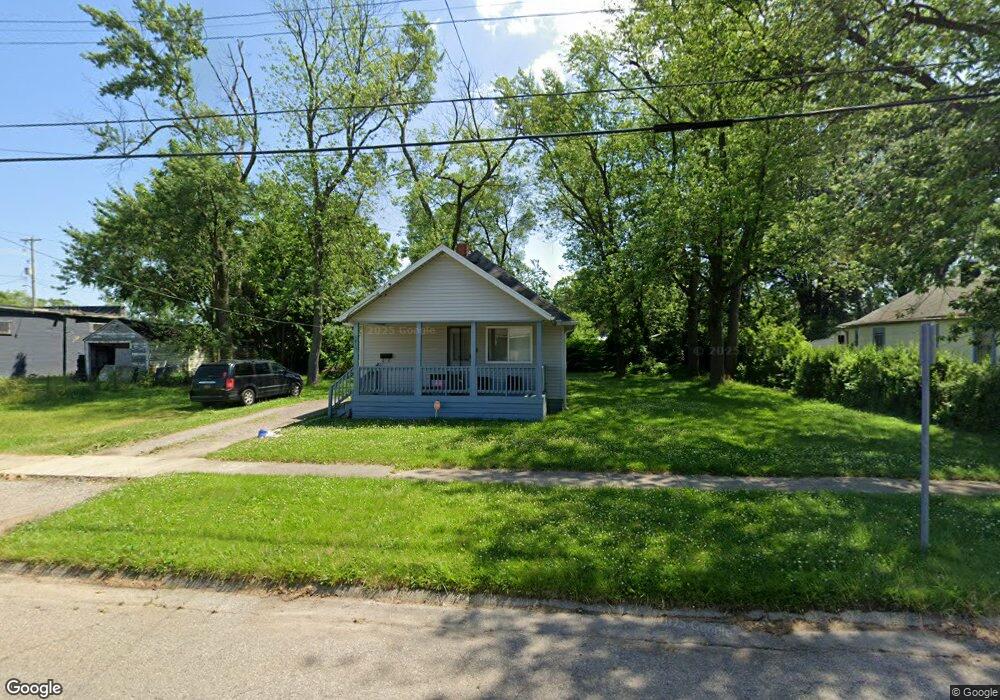
1015 Leland St Flint, MI 48507
South Side NeighborhoodEstimated Value: $43,000 - $54,000
2
Beds
1
Bath
748
Sq Ft
$64/Sq Ft
Est. Value
About This Home
This home is located at 1015 Leland St, Flint, MI 48507 and is currently estimated at $48,133, approximately $64 per square foot. 1015 Leland St is a home located in Genesee County with nearby schools including Neithercut Elementary School, Flint Southwestern Classical Academy, and International Academy of Flint (K-12).
Ownership History
Date
Name
Owned For
Owner Type
Purchase Details
Closed on
May 13, 2005
Sold by
Hardenburg Kevin B and Hardenburg Mary
Bought by
Barrett Harry D
Current Estimated Value
Purchase Details
Closed on
Oct 19, 2002
Sold by
Kildee Daniel
Bought by
Hardenburg Kevin B
Create a Home Valuation Report for This Property
The Home Valuation Report is an in-depth analysis detailing your home's value as well as a comparison with similar homes in the area
Home Values in the Area
Average Home Value in this Area
Purchase History
| Date | Buyer | Sale Price | Title Company |
|---|---|---|---|
| Barrett Harry D | $40,000 | Metropolitan Title Company | |
| Hardenburg Kevin B | $14,000 | -- |
Source: Public Records
Tax History Compared to Growth
Tax History
| Year | Tax Paid | Tax Assessment Tax Assessment Total Assessment is a certain percentage of the fair market value that is determined by local assessors to be the total taxable value of land and additions on the property. | Land | Improvement |
|---|---|---|---|---|
| 2025 | $944 | $15,200 | $0 | $0 |
| 2024 | $879 | $15,500 | $0 | $0 |
| 2023 | $863 | $12,500 | $0 | $0 |
| 2022 | $0 | $11,300 | $0 | $0 |
| 2021 | $872 | $10,100 | $0 | $0 |
| 2020 | $807 | $10,100 | $0 | $0 |
| 2019 | $792 | $10,300 | $0 | $0 |
| 2018 | $772 | $8,300 | $0 | $0 |
| 2017 | $753 | $0 | $0 | $0 |
| 2016 | $749 | $0 | $0 | $0 |
| 2015 | -- | $0 | $0 | $0 |
| 2014 | -- | $0 | $0 | $0 |
| 2012 | -- | $10,300 | $0 | $0 |
Source: Public Records
Map
Nearby Homes
- 1028 Campbell St
- 1130 W Atherton Rd
- 1212 Crawford St
- 1228 Leland St
- 1015 Alvord Ave
- 1225 Waldman Ave
- 1410 Berrywood Ln
- 1234 Huron St
- 1209 Lincoln Ave
- 1310 Huron St
- 1031 Ingleside Ave
- 845 Alvord Ave
- 1418 Blueberry Ln
- 822 Campbell St
- 936 Lincoln Ave
- 818 Alvord Ave
- 1225 Vermilya Ave
- 1318 Ingleside Ave
- 1210 Pinehurst Ave
- 4418 Brunswick Ave
- 1023 Leland St
- 1027 Leland St
- 1020 Crawford St
- 1016 Crawford St
- 1028 Crawford St
- 1012 Crawford St
- 1032 Crawford St
- 1022 Leland St
- 4014 Fenton Rd
- 1016 Leland St
- 1024 Leland St
- 4010 Fenton Rd
- 1036 Crawford St
- 1032 Leland St
- 4022 Fenton Rd
- 3920 Fenton Rd
- 1043 Leland St
- 3918 Fenton Rd
- 1011 Campbell St
- 1015 Campbell St