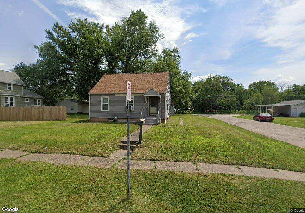
1015 S Michigan Ave Davenport, IA 52802
West End NeighborhoodEstimated Value: $86,000 - $102,000
2
Beds
1
Bath
672
Sq Ft
$142/Sq Ft
Est. Value
About This Home
This home is located at 1015 S Michigan Ave, Davenport, IA 52802 and is currently estimated at $95,162, approximately $141 per square foot. 1015 S Michigan Ave is a home located in Scott County with nearby schools including Walnut Hill Elementary School, Frank L. Smart Intermediate School, and West High School.
Ownership History
Date
Name
Owned For
Owner Type
Purchase Details
Closed on
May 24, 2005
Sold by
Gray Richard E and Gray Janet K
Bought by
Setser Jason E and Corry Jessica E
Current Estimated Value
Home Financials for this Owner
Home Financials are based on the most recent Mortgage that was taken out on this home.
Original Mortgage
$73,420
Outstanding Balance
$38,454
Interest Rate
5.91%
Mortgage Type
FHA
Estimated Equity
$56,708
Create a Home Valuation Report for This Property
The Home Valuation Report is an in-depth analysis detailing your home's value as well as a comparison with similar homes in the area
Home Values in the Area
Average Home Value in this Area
Purchase History
| Date | Buyer | Sale Price | Title Company |
|---|---|---|---|
| Setser Jason E | $74,000 | Excel Title |
Source: Public Records
Mortgage History
| Date | Status | Borrower | Loan Amount |
|---|---|---|---|
| Open | Setser Jason E | $73,420 |
Source: Public Records
Tax History Compared to Growth
Tax History
| Year | Tax Paid | Tax Assessment Tax Assessment Total Assessment is a certain percentage of the fair market value that is determined by local assessors to be the total taxable value of land and additions on the property. | Land | Improvement |
|---|---|---|---|---|
| 2025 | $1,646 | $78,830 | $15,930 | $62,900 |
| 2024 | $1,714 | $78,830 | $15,930 | $62,900 |
| 2023 | $1,627 | $78,830 | $15,930 | $62,900 |
| 2022 | $1,692 | $67,670 | $13,720 | $53,950 |
| 2021 | $1,260 | $67,670 | $13,720 | $53,950 |
| 2020 | $1,381 | $63,770 | $13,720 | $50,050 |
| 2019 | $1,441 | $63,770 | $13,720 | $50,050 |
| 2018 | $611 | $63,770 | $13,720 | $50,050 |
| 2017 | $339 | $60,990 | $13,720 | $47,270 |
| 2016 | $1,526 | $60,990 | $0 | $0 |
| 2015 | $1,144 | $54,620 | $0 | $0 |
| 2014 | $1,020 | $54,620 | $0 | $0 |
| 2013 | $998 | $0 | $0 | $0 |
| 2012 | -- | $56,580 | $16,190 | $40,390 |
Source: Public Records
Map
Nearby Homes
- 1109 S Michigan Ave
- 3207 Homestead Ave
- 3228 Sunnyside Ave
- 3412 Michigan
- 3154 Diehn Ave
- 815 S Dittmer St
- 2736 Rockingham Rd
- 520 S Clark St
- 2707 Jackson Ave
- 2614 Mckinley Ave
- 3011 Telegraph Rd
- 2537 Boies Ave
- 2502 Rockingham Rd
- 2639 Whitewood Ave
- 125 S Birchwood Ave
- 223 S Lincoln Ave
- 124 N Elmwood Ave
- 131 S Lincoln Ave
- 2312 W 1st St
- 2312 1/2 W 1st St
- 1005 S Michigan Ave
- 1101 S Michigan Ave
- 933 S Michigan Ave
- 1105 S Michigan Ave
- 929 S Michigan Ave
- 1014 S Michigan Ave
- 1010 S Michigan Ave
- 927 S Michigan Ave
- 1104 S Michigan Ave
- 1014 S Ohio Ave
- 934 S Michigan Ave
- 1106 S Michigan Ave
- 923 S Michigan Ave
- 1115 S Michigan Ave
- 1102 S Ohio Ave
- 1004 S Ohio Ave
- 1108 S Ohio Ave
- 936 S Ohio Ave
- 930 S Michigan Ave
- 1112 S Michigan Ave