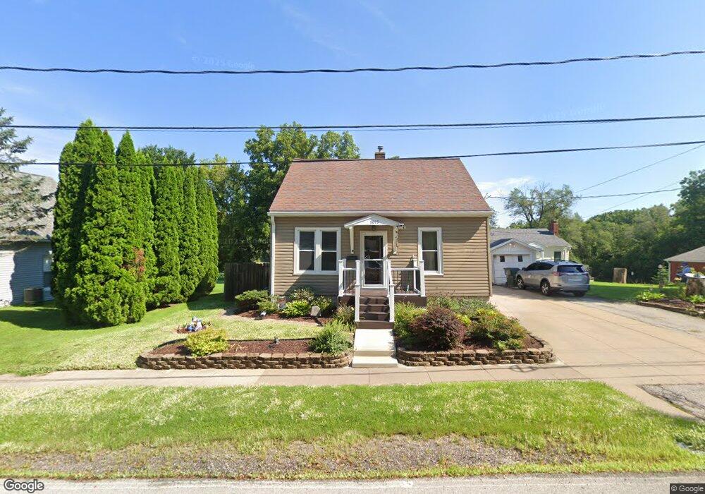
1015 Stone St Muscatine, IA 52761
Estimated Value: $152,000 - $170,000
3
Beds
3
Baths
1,128
Sq Ft
$140/Sq Ft
Est. Value
About This Home
This home is located at 1015 Stone St, Muscatine, IA 52761 and is currently estimated at $157,567, approximately $139 per square foot. 1015 Stone St is a home located in Muscatine County with nearby schools including McKinley Elementary School, Susan Clark Junior High School, and Muscatine High School.
Ownership History
Date
Name
Owned For
Owner Type
Purchase Details
Closed on
Oct 8, 2007
Sold by
Jones Douglas P and Jones Julie A
Bought by
Whisler Gerald L and Whisler Laurette
Current Estimated Value
Purchase Details
Closed on
Aug 5, 2005
Sold by
Houten Fred L Van and Houten Lawrence G Van
Bought by
Jones Douglas P and Jones Julie A
Home Financials for this Owner
Home Financials are based on the most recent Mortgage that was taken out on this home.
Original Mortgage
$65,600
Interest Rate
5.66%
Mortgage Type
New Conventional
Create a Home Valuation Report for This Property
The Home Valuation Report is an in-depth analysis detailing your home's value as well as a comparison with similar homes in the area
Home Values in the Area
Average Home Value in this Area
Purchase History
| Date | Buyer | Sale Price | Title Company |
|---|---|---|---|
| Whisler Gerald L | $87,500 | None Available | |
| Jones Douglas P | $81,500 | None Available |
Source: Public Records
Mortgage History
| Date | Status | Borrower | Loan Amount |
|---|---|---|---|
| Previous Owner | Jones Douglas P | $65,600 |
Source: Public Records
Tax History Compared to Growth
Tax History
| Year | Tax Paid | Tax Assessment Tax Assessment Total Assessment is a certain percentage of the fair market value that is determined by local assessors to be the total taxable value of land and additions on the property. | Land | Improvement |
|---|---|---|---|---|
| 2025 | $1,972 | $119,150 | $16,770 | $102,380 |
| 2024 | $1,972 | $119,020 | $16,770 | $102,250 |
| 2023 | $1,888 | $118,953 | $16,780 | $102,173 |
| 2022 | $1,744 | $104,890 | $15,830 | $89,060 |
| 2021 | $1,744 | $94,420 | $15,830 | $78,590 |
| 2020 | $1,708 | $90,050 | $15,830 | $74,220 |
| 2019 | $1,694 | $85,240 | $0 | $0 |
| 2018 | $1,666 | $85,140 | $0 | $0 |
| 2017 | $1,666 | $85,140 | $0 | $0 |
| 2016 | $1,728 | $85,140 | $0 | $0 |
| 2015 | $1,728 | $83,250 | $0 | $0 |
| 2014 | $1,698 | $83,250 | $0 | $0 |
Source: Public Records
Map
Nearby Homes
- 602 W Fulliam Ave
- 1506 Buell St
- 241 Dillaway St
- PARCEL ID 0834280023 Dillaway St
- 518 Roscoe Ave
- 310 Wood Creek Ln
- 2109 Americana Ave
- 1619 Devitt Ave
- 297 Burnside Ave
- 1807 Mulberry Ave
- 35 Colony Dr
- 1102 Cedar St
- 1143 Logan St
- 1617 W Acre Dr
- 836 Newell Ave
- 606 Leroy St
- 205 Amherst Ave
- 106 W 9th St
- 804 Iowa Ave
- 0 High Street Parcel
- 1013 Stone St
- 1017 Stone St
- 1007 Stone St
- 1021 Stone St
- 1604 Foster St
- 508 1/2 Lorenz St
- 1608 Foster St
- 1718 Buell St
- 1612 Foster St
- 1045 Stone St
- 505 W Fulliam Ave
- 1700 Foster St
- 1049 Stone St
- 606 W Fulliam Ave
- 610 W Fulliam Ave
- 1605 Foster St
- 614 W Fulliam Ave
- 415 W Fulliam Ave
- 1609 Foster St
- 1708 Foster St