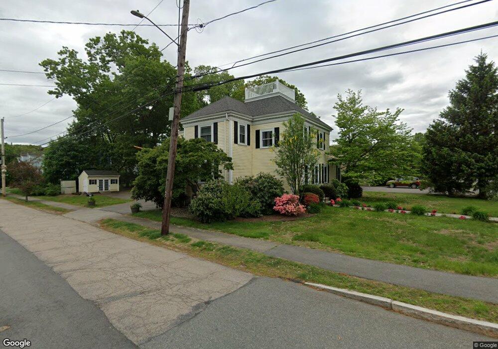
1016 Canton Ave Milton, MA 02186
Brush Hill NeighborhoodEstimated Value: $1,170,000 - $1,277,000
4
Beds
2
Baths
2,261
Sq Ft
$542/Sq Ft
Est. Value
About This Home
This home is located at 1016 Canton Ave, Milton, MA 02186 and is currently estimated at $1,225,473, approximately $542 per square foot. 1016 Canton Ave is a home located in Norfolk County with nearby schools including Milton High School, Delphi Academy of Boston, and Milton Academy.
Ownership History
Date
Name
Owned For
Owner Type
Purchase Details
Closed on
Aug 9, 2025
Sold by
Foulkes Janet A
Bought by
Janet Ann Foulkes Irt and Hildebrand
Current Estimated Value
Purchase Details
Closed on
Jun 30, 1994
Sold by
Connelly Peter J and Connelly Kathleen A
Bought by
Hildebrand Robert C and Hildebrand Janet Af
Create a Home Valuation Report for This Property
The Home Valuation Report is an in-depth analysis detailing your home's value as well as a comparison with similar homes in the area
Home Values in the Area
Average Home Value in this Area
Purchase History
| Date | Buyer | Sale Price | Title Company |
|---|---|---|---|
| Janet Ann Foulkes Irt | -- | -- | |
| Janet Ann Foulkes Irt | -- | -- | |
| Hildebrand Robert C | $230,000 | -- |
Source: Public Records
Mortgage History
| Date | Status | Borrower | Loan Amount |
|---|---|---|---|
| Previous Owner | Hildebrand Robert C | $25,000 | |
| Previous Owner | Hildebrand Robert C | $347,500 |
Source: Public Records
Tax History Compared to Growth
Tax History
| Year | Tax Paid | Tax Assessment Tax Assessment Total Assessment is a certain percentage of the fair market value that is determined by local assessors to be the total taxable value of land and additions on the property. | Land | Improvement |
|---|---|---|---|---|
| 2025 | $10,914 | $984,100 | $453,300 | $530,800 |
| 2024 | $10,512 | $962,600 | $431,800 | $530,800 |
| 2023 | $10,275 | $901,300 | $411,400 | $489,900 |
| 2022 | $9,881 | $792,400 | $411,400 | $381,000 |
| 2021 | $9,614 | $732,200 | $369,100 | $363,100 |
| 2020 | $9,297 | $708,600 | $353,700 | $354,900 |
| 2019 | $9,069 | $688,100 | $343,400 | $344,700 |
| 2018 | $9,102 | $659,100 | $317,300 | $341,800 |
| 2017 | $8,517 | $628,100 | $302,200 | $325,900 |
| 2016 | $8,176 | $605,600 | $287,000 | $318,600 |
| 2015 | $7,687 | $551,400 | $243,200 | $308,200 |
Source: Public Records
Map
Nearby Homes
- 7 Preacher Rd
- 375 Atherton St
- 200 Robbins St
- 350 Blue Hill Ave
- 485 Blue Hills Pkwy Unit 11
- 485 Blue Hills Pkwy Unit 27
- 485 Blue Hills Pkwy Unit 6
- 485 Blue Hills Pkwy Unit 21
- 485 Blue Hills Pkwy Unit 44
- 485 Blue Hills Pkwy Unit 23
- 485 Blue Hills Pkwy Unit 20
- 485 Blue Hills Pkwy Unit 26
- 485 Blue Hills Pkwy Unit 28
- 485 Blue Hills Pkwy Unit 2
- 485 Blue Hills Pkwy Unit 33
- 40 Lafayette St
- 589 Brush Hill Rd
- 405 Blue Hill Ave
- 16 Prospect St
- 5 Kinsale Ln