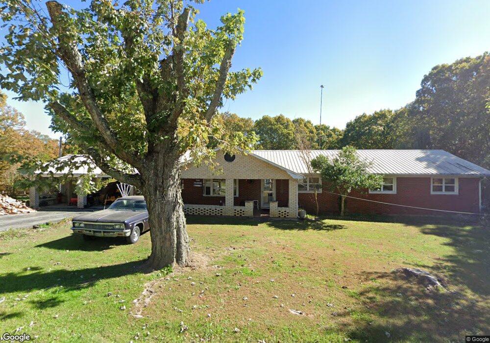
1016 Kings Loop Jamestown, TN 38556
Estimated Value: $194,876 - $313,000
Studio
1
Bath
1,612
Sq Ft
$155/Sq Ft
Est. Value
About This Home
This home is located at 1016 Kings Loop, Jamestown, TN 38556 and is currently estimated at $249,719, approximately $154 per square foot. 1016 Kings Loop is a home located in Fentress County with nearby schools including Cumberland Christian School.
Ownership History
Date
Name
Owned For
Owner Type
Purchase Details
Closed on
Oct 22, 2004
Bought by
Turner Sammy J and Le %Sammy J Turner
Current Estimated Value
Purchase Details
Closed on
Jun 29, 1998
Bought by
Turner Sdammy J and Turner Martha A
Purchase Details
Closed on
Jun 26, 1992
Bought by
Ross Joseph A and Ross Anna Marie
Purchase Details
Closed on
Dec 26, 1989
Bought by
Teeple James C
Create a Home Valuation Report for This Property
The Home Valuation Report is an in-depth analysis detailing your home's value as well as a comparison with similar homes in the area
Purchase History
| Date | Buyer | Sale Price | Title Company |
|---|---|---|---|
| Turner Sammy J | $35,000 | -- | |
| Turner Sdammy J | $65,000 | -- | |
| Ross Joseph A | $63,000 | -- | |
| Teeple James C | $37,000 | -- |
Source: Public Records
Tax History
| Year | Tax Paid | Tax Assessment Tax Assessment Total Assessment is a certain percentage of the fair market value that is determined by local assessors to be the total taxable value of land and additions on the property. | Land | Improvement |
|---|---|---|---|---|
| 2025 | $534 | $39,575 | $4,925 | $34,650 |
| 2024 | $534 | $39,575 | $4,925 | $34,650 |
| 2023 | $534 | $39,575 | $4,925 | $34,650 |
| 2022 | $456 | $23,875 | $4,925 | $18,950 |
| 2021 | $456 | $23,875 | $4,925 | $18,950 |
| 2020 | $456 | $23,875 | $4,925 | $18,950 |
| 2019 | $456 | $23,875 | $4,925 | $18,950 |
| 2018 | $456 | $23,875 | $4,925 | $18,950 |
| 2017 | $451 | $22,725 | $4,700 | $18,025 |
| 2016 | $451 | $22,725 | $4,700 | $18,025 |
| 2015 | $451 | $22,730 | $0 | $0 |
| 2014 | $451 | $22,730 | $0 | $0 |
Source: Public Records
Map
Nearby Homes
- 957 Allardt Hwy
- 1128 Allardt Hwy
- 319 Annabelle Way
- 1226 Allardt Hwy Unit 1226
- 1228 Allardt Hwy Unit 1228
- 422 Peach Ln
- 822 Allardt Hwy
- - Lake Shore Dr
- 111 Guffey Ln
- 1115 Frank Campbell Rd
- 111 Summit Dr
- 880 Allardt Hwy
- 1401 Pennsylvania Ave
- n/a Holt Spur Rd
- 98 Paso Fino Trail
- 0 Allardt Hwy Unit 1316911
- 0 Allardt Hwy Unit 1319314
- 2296 Memory Garden Rd
- 1015 Kings Loop
- 1018 Kings Loop
- 1017B Kings Loop
- 107 Pa Choate Rd
- 1019 Kings Loop
- 1020 Kings Loop
- 1009 Kings Loop
- 1010 Kings Loop
- 129 Pa Choate Rd
- 112 Pa Choate Rd
- 1021 Allardt Hwy Unit 1021
- 1025 Allardt Highway 1025 Hwy
- 1029 Allardt Hwy
- 1015 Allart Hwy
- 1015 Allardt Hwy
- 1026 Kings Loop
- 1032 Kings Loop
- 1031 Allardt Hwy
- 1024 Allardt Hwy
- 1014 Highway 52
Your Personal Tour Guide
Ask me questions while you tour the home.