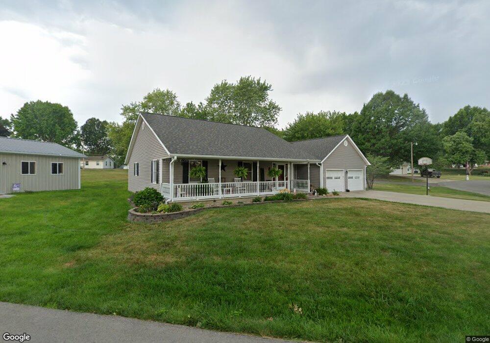
1016 Morningside Dr Salisbury, MO 65281
Estimated Value: $235,624 - $440,000
Studio
--
Bath
--
Sq Ft
0.3
Acres
About This Home
This home is located at 1016 Morningside Dr, Salisbury, MO 65281 and is currently estimated at $293,656. 1016 Morningside Dr is a home with nearby schools including Salisbury Elementary School, Salisbury High School, and St. Joseph School.
Ownership History
Date
Name
Owned For
Owner Type
Purchase Details
Closed on
May 12, 2020
Sold by
Brown Chris
Bought by
Brown Lori
Current Estimated Value
Home Financials for this Owner
Home Financials are based on the most recent Mortgage that was taken out on this home.
Original Mortgage
$60,000
Outstanding Balance
$50,375
Interest Rate
3.1%
Mortgage Type
Closed End Mortgage
Estimated Equity
$243,281
Purchase Details
Closed on
Feb 13, 2019
Sold by
Jordan Donald E and Jordan Dorothy R
Bought by
Brown Kevin E and Brown Denise M
Home Financials for this Owner
Home Financials are based on the most recent Mortgage that was taken out on this home.
Original Mortgage
$40,000
Interest Rate
4.4%
Mortgage Type
Future Advance Clause Open End Mortgage
Create a Home Valuation Report for This Property
The Home Valuation Report is an in-depth analysis detailing your home's value as well as a comparison with similar homes in the area
Purchase History
| Date | Buyer | Sale Price | Title Company |
|---|---|---|---|
| Brown Lori | -- | None Available | |
| Brown Kevin E | -- | None Available |
Source: Public Records
Mortgage History
| Date | Status | Borrower | Loan Amount |
|---|---|---|---|
| Open | Brown Lori | $60,000 | |
| Closed | Brown Kevin E | $40,000 |
Source: Public Records
Tax History
| Year | Tax Paid | Tax Assessment Tax Assessment Total Assessment is a certain percentage of the fair market value that is determined by local assessors to be the total taxable value of land and additions on the property. | Land | Improvement |
|---|---|---|---|---|
| 2025 | $2,356 | $33,840 | $0 | $0 |
| 2024 | $2,365 | $33,840 | $0 | $0 |
| 2023 | $2,265 | $171,160 | $0 | $0 |
| 2022 | $2,269 | $171,160 | $0 | $0 |
| 2021 | $2,284 | $171,160 | $0 | $0 |
| 2020 | $2,299 | $32,520 | $0 | $0 |
| 2019 | $2,301 | $0 | $0 | $0 |
| 2018 | $1,765 | $130,100 | $0 | $0 |
| 2017 | $1,774 | $130,100 | $0 | $0 |
| 2016 | $1,776 | $24,720 | $0 | $0 |
| 2015 | -- | $24,720 | $0 | $0 |
| 2014 | -- | $24,720 | $0 | $0 |
Source: Public Records
Map
Nearby Homes
- 1204 S Walnut Ave
- 606 E 4th St
- 32136 Missouri 129
- 0 County Road 152
- Hwy U Unit County Road 2045
- 112 S Rucker St
- n/a Holman St
- 447 Holman St
- 1041 Doeskin Ct
- Highway 24 Lot Unit WP001
- 0 24 Hwy Hwy Unit HMS2565633
- 1013 County Rd 2025
- 1013 County Road 2025
- 000 State Highway O
- 1506 County Road 2407
- 0 Cr 2407 Unit MIS26005245
- 0 Cr 2407 Unit MIS26005233
- 0 Cr 2407 Unit MIS26005238
- 0 Hwy J Unit 25955056
- 1 W Barlett St
- 24 Morningside Dr
- 1005 Morningside Dr
- 1023 Morningside Dr
- 1025 Morningside Dr
- 1010 Morningside Dr
- 1028 Morningside Dr
- 107 Melody Ln
- 109 Melody Ln
- 1003 Morningside Dr
- 1033 Morningside Dr
- 1057 Morningside Dr
- 1065 Morningside Dr
- 1004 Morningside Dr
- 1045 Morningside Dr
- 1009 S Broadway
- 105 Melody Ln
- 111 Melody Ln
- 1039 Morningside Dr
- 1032 Morningside Dr
- 113 Melody Ln
Your Personal Tour Guide
Ask me questions while you tour the home.