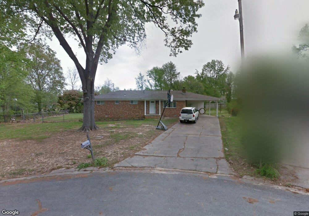
1017 Oakhurst Dr Jacksonville, AR 72076
Estimated Value: $137,683 - $190,000
4
Beds
2
Baths
1,676
Sq Ft
$99/Sq Ft
Est. Value
About This Home
This home is located at 1017 Oakhurst Dr, Jacksonville, AR 72076 and is currently estimated at $165,171, approximately $98 per square foot. 1017 Oakhurst Dr is a home located in Pulaski County with nearby schools including Jacksonville Elementary School, Jacksonville Middle School, and Jacksonville High School.
Ownership History
Date
Name
Owned For
Owner Type
Purchase Details
Closed on
May 25, 1998
Sold by
Thompson Virginia and Breckenridge Linda
Bought by
Bart Gray Realty Co Inc
Current Estimated Value
Create a Home Valuation Report for This Property
The Home Valuation Report is an in-depth analysis detailing your home's value as well as a comparison with similar homes in the area
Home Values in the Area
Average Home Value in this Area
Purchase History
| Date | Buyer | Sale Price | Title Company |
|---|---|---|---|
| Bart Gray Realty Co Inc | $72,000 | Beach Abstract & Guaranty Co |
Source: Public Records
Tax History Compared to Growth
Tax History
| Year | Tax Paid | Tax Assessment Tax Assessment Total Assessment is a certain percentage of the fair market value that is determined by local assessors to be the total taxable value of land and additions on the property. | Land | Improvement |
|---|---|---|---|---|
| 2025 | $1,235 | $20,117 | $7,500 | $12,617 |
| 2024 | $1,082 | $20,117 | $7,500 | $12,617 |
| 2023 | $1,082 | $20,117 | $7,500 | $12,617 |
| 2022 | $914 | $20,117 | $7,500 | $12,617 |
| 2021 | $831 | $13,540 | $5,400 | $8,140 |
| 2020 | $831 | $13,540 | $5,400 | $8,140 |
| 2019 | $831 | $13,540 | $5,400 | $8,140 |
| 2018 | $831 | $13,540 | $5,400 | $8,140 |
| 2017 | $831 | $13,540 | $5,400 | $8,140 |
| 2016 | $758 | $12,340 | $5,400 | $6,940 |
| 2015 | $664 | $12,340 | $5,400 | $6,940 |
| 2014 | $664 | $12,340 | $5,400 | $6,940 |
Source: Public Records
Map
Nearby Homes
- 1025 Oakhurst Dr
- 1007 N Jeff Davis Ave
- 1009 N Jeff Davis Ave
- 1001 N Jeff Davis Ave
- 1019 N Jeff Davis Ave
- 1005 N Jeff Davis Ave
- 933 N Jeff Davis Ave
- 929 N Jeff Davis Ave
- 1311 Lee St
- 00 U S Highway 67
- 1317 Hendrix Dr
- 709 Hill St
- 604 N James St
- 712 Harpole St
- 705 Harpole St
- 1309 Gregory St
- 002 N Hospital Dr
- 601 Harpole St
- 704 Brewer St
- 513 Harpole St
- 1013 Oakhurst Dr
- 35 Blackwell St
- 1008 N Jeff Davis St
- 31 Blackwell St
- 1004 N Jeff Davis St
- 1010 N Jeff Davis St
- 1009 Oakhurst Dr
- 1000 N Jeff Davis St
- 1004 Oakhurst Dr
- 1029 Oakhurst Dr
- 1012 N Jeff Davis St
- 27 Blackwell St
- 1005 Oakhurst Dr
- 926 N Jeff Davis St
- 19 Blackwell St
- 1201 Oakhurst Dr
- 15 Blackwell St
- 1200 Lee St
- 924 N Jeff Davis St
- 1001 Oakhurst Dr