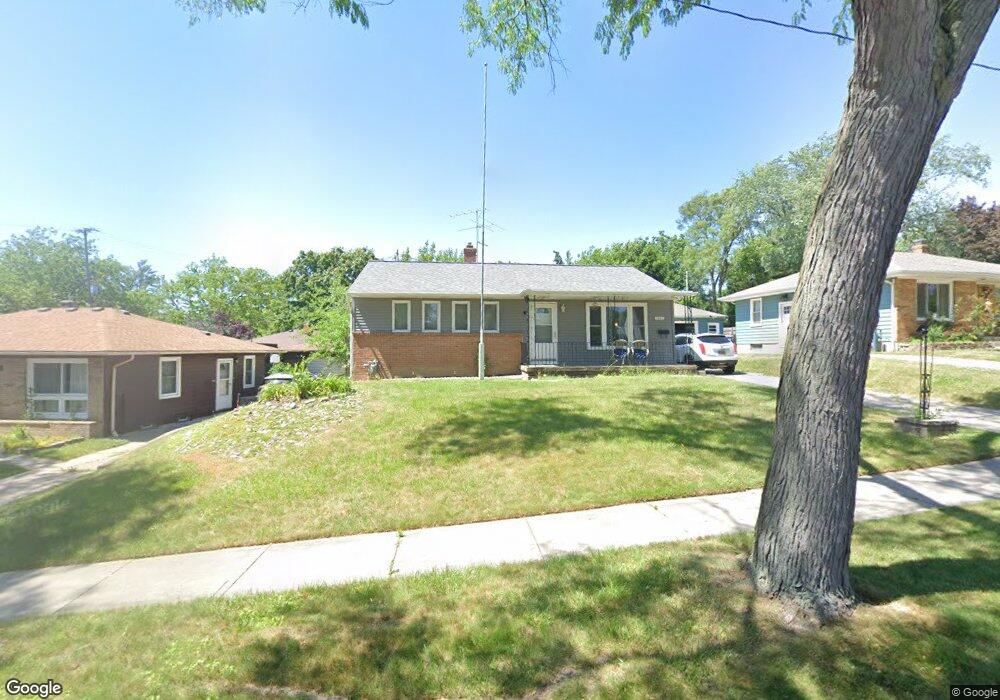
1017 Truxton Ave NE Grand Rapids, MI 49505
Creston NeighborhoodEstimated Value: $276,000 - $306,349
4
Beds
2
Baths
1,664
Sq Ft
$175/Sq Ft
Est. Value
About This Home
This home is located at 1017 Truxton Ave NE, Grand Rapids, MI 49505 and is currently estimated at $291,837, approximately $175 per square foot. 1017 Truxton Ave NE is a home located in Kent County with nearby schools including Kent Hills School, Riverside Middle School, and Union High School.
Ownership History
Date
Name
Owned For
Owner Type
Purchase Details
Closed on
Feb 16, 2005
Sold by
Kroes Martin R
Bought by
Talbert Lynnell A
Current Estimated Value
Home Financials for this Owner
Home Financials are based on the most recent Mortgage that was taken out on this home.
Original Mortgage
$118,900
Outstanding Balance
$60,276
Interest Rate
5.71%
Mortgage Type
Purchase Money Mortgage
Estimated Equity
$231,561
Purchase Details
Closed on
May 17, 1990
Sold by
Schader Ditmr
Bought by
Talbert Lynnell A
Create a Home Valuation Report for This Property
The Home Valuation Report is an in-depth analysis detailing your home's value as well as a comparison with similar homes in the area
Home Values in the Area
Average Home Value in this Area
Purchase History
| Date | Buyer | Sale Price | Title Company |
|---|---|---|---|
| Talbert Lynnell A | $118,900 | -- | |
| Talbert Lynnell A | $55,000 | -- |
Source: Public Records
Mortgage History
| Date | Status | Borrower | Loan Amount |
|---|---|---|---|
| Open | Talbert Lynnell A | $118,900 |
Source: Public Records
Tax History Compared to Growth
Tax History
| Year | Tax Paid | Tax Assessment Tax Assessment Total Assessment is a certain percentage of the fair market value that is determined by local assessors to be the total taxable value of land and additions on the property. | Land | Improvement |
|---|---|---|---|---|
| 2025 | $1,614 | $128,400 | $0 | $0 |
| 2024 | $1,614 | $117,700 | $0 | $0 |
| 2023 | $1,637 | $99,800 | $0 | $0 |
| 2022 | $1,554 | $85,500 | $0 | $0 |
| 2021 | $1,520 | $77,900 | $0 | $0 |
| 2020 | $1,453 | $71,800 | $0 | $0 |
| 2019 | $1,522 | $60,000 | $0 | $0 |
| 2018 | $1,469 | $54,300 | $0 | $0 |
| 2017 | $1,430 | $50,200 | $0 | $0 |
| 2016 | $1,448 | $45,100 | $0 | $0 |
| 2015 | $1,347 | $45,100 | $0 | $0 |
| 2013 | -- | $39,600 | $0 | $0 |
Source: Public Records
Map
Nearby Homes
- 1848 Emerald Ave NE
- 1824 Herrick Ave NE
- 1119 Kentwood Dr NE
- 1825 Meadowfield Dr NE
- 1757 Westlane Dr NE
- 2100 Dawson Ave NE
- 921 Eleanor St NE
- 1237 Dale Ct NE
- 1335 Knapp St NE
- 2038 Melita Ave NE
- 2027 Joan Ave NE
- 738 Graceland St NE
- 778 Eleanor St NE
- 612 Woodridge St NE
- 1666 Carlton Ave NE
- 2019 Plainfield Ave NE
- 861 Aberdeen St NE
- 1119 Spencer St NE
- 1444 Sweet St NE
- 2030 Sinclair Ave NE
- 1011 Truxton Ave NE
- 1025 Truxton Ave NE
- 1922 Diamond Ave NE
- 1914 Diamond Ave NE
- 1031 Truxton Ave NE
- 1031 Truxton Dr NE
- 1926 Diamond Ave NE
- 1932 Diamond Ave NE
- 1039 Truxton Ave NE
- 1024 Truxton Ave NE
- 1014 Truxton Ave NE
- 1030 Truxton Ave NE
- 1010 Truxton Ave NE
- 1036 Truxton Ave NE
- 1047 Truxton Ave NE
- 1856 Diamond Ave NE
- 1938 Diamond Ave NE
- 1909 Diamond Ave NE
- 1040 Truxton Ave NE
- 1055 Truxton Ave NE