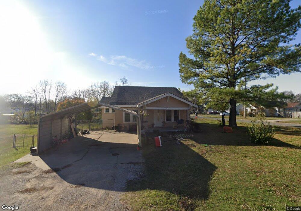
1017 W Merrick St Henryetta, OK 74437
Estimated Value: $106,796 - $148,000
3
Beds
1
Bath
1,412
Sq Ft
$84/Sq Ft
Est. Value
About This Home
This home is located at 1017 W Merrick St, Henryetta, OK 74437 and is currently estimated at $118,449, approximately $83 per square foot. 1017 W Merrick St is a home located in Okmulgee County with nearby schools including Henryetta Elementary School, Henryetta Middle School, and Henryetta High School.
Ownership History
Date
Name
Owned For
Owner Type
Purchase Details
Closed on
Oct 28, 2011
Sold by
Geera Dainel Blake Powell
Bought by
Farrow John L and Farrow Willie Shannon Marie
Current Estimated Value
Purchase Details
Closed on
Oct 1, 2004
Sold by
Stinebrickner Rubey
Bought by
Powell Daniel Blake
Purchase Details
Closed on
Feb 12, 2002
Sold by
Centex Home Equity
Bought by
Stinebrickner Clem and Stinebrickner Mar
Purchase Details
Closed on
Sep 8, 1997
Sold by
Polston Kenneth and Polston Gloria
Bought by
Lewis Walter and Lewis Irene
Create a Home Valuation Report for This Property
The Home Valuation Report is an in-depth analysis detailing your home's value as well as a comparison with similar homes in the area
Home Values in the Area
Average Home Value in this Area
Purchase History
| Date | Buyer | Sale Price | Title Company |
|---|---|---|---|
| Farrow John L | -- | None Available | |
| Powell Daniel Blake | $40,000 | -- | |
| Stinebrickner Clem | $22,000 | -- | |
| Lewis Walter | $35,000 | -- |
Source: Public Records
Tax History Compared to Growth
Tax History
| Year | Tax Paid | Tax Assessment Tax Assessment Total Assessment is a certain percentage of the fair market value that is determined by local assessors to be the total taxable value of land and additions on the property. | Land | Improvement |
|---|---|---|---|---|
| 2025 | $400 | $4,163 | $180 | $3,983 |
| 2024 | $400 | $3,965 | $180 | $3,785 |
| 2023 | $387 | $3,965 | $180 | $3,785 |
| 2022 | $483 | $4,938 | $180 | $4,758 |
| 2021 | $490 | $4,938 | $180 | $4,758 |
| 2020 | $490 | $4,940 | $180 | $4,760 |
| 2019 | $582 | $5,939 | $180 | $5,759 |
| 2018 | $644 | $6,539 | $180 | $6,359 |
| 2017 | $645 | $6,539 | $180 | $6,359 |
| 2016 | $704 | $7,139 | $180 | $6,959 |
| 2015 | $576 | $7,281 | $180 | $7,101 |
| 2014 | $613 | $7,632 | $180 | $7,452 |
Source: Public Records
Map
Nearby Homes
- 810 W Gentry St
- 805 W Gentry St
- 911 W Trudgeon St
- 602 W Cummings St
- 611 W Gentry St
- 1403 W Division St
- 502 W Merrick St
- 512 N 4th St
- 1205 N 8th St
- 407 N 2nd St
- 112 W Merrick St
- 104500 S 4095 Rd
- 1103 Oakwood Cir
- 1409 N 5th St
- 709 W Corporation St
- 612 NE 1st St
- 304 Hickory Dr
- 202 E John St
- 1503 Briarwood Ln
- 1508 Briarwood Ln
- 511 N 11th St
- 1018 W Cummings St
- 1009 W Merrick St
- 1012 W Cummings St
- 1010 W Merrick St
- 1016 W Merrick St
- 1102 W Cummings St
- 1007 W Merrick St
- 1102 W Merrick St
- 1010 W Cummings St
- 1012 W Merrick St
- 1106 W Cummings St
- 1008 W Cummings St
- 1104 W Merrick St
- 1108 W Cummings St
- 1006 W Cummings St
- 512 N 12th St
- 1108 W Merrick St
- 1017 W Cummings St