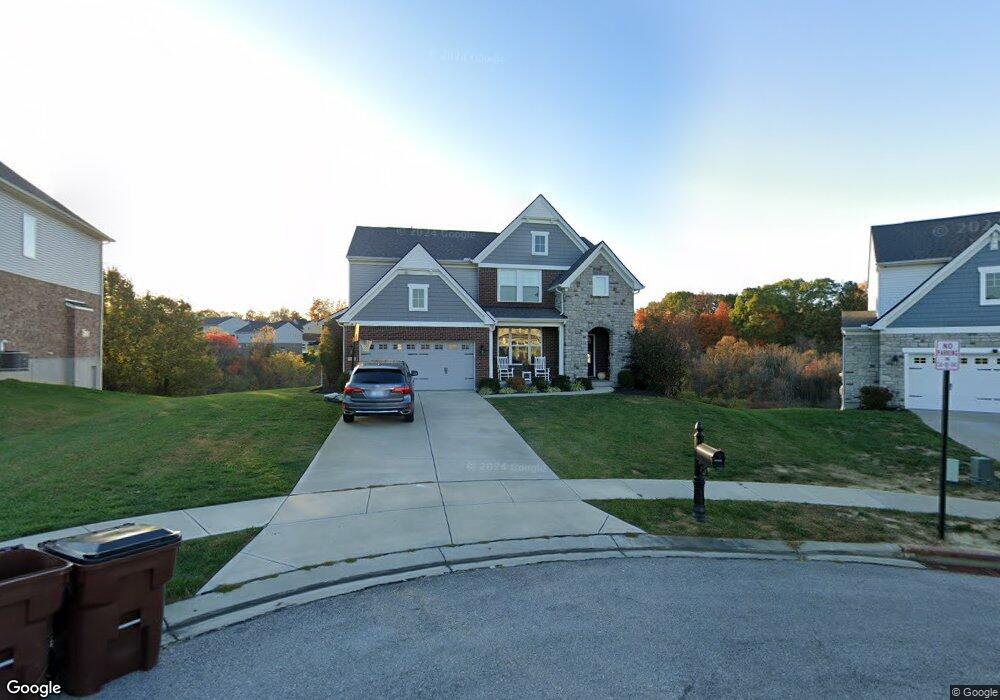
10172 Hibernia Ct Covington, KY 41015
Estimated Value: $497,000 - $565,000
4
Beds
4
Baths
3,041
Sq Ft
$173/Sq Ft
Est. Value
About This Home
This home is located at 10172 Hibernia Ct, Covington, KY 41015 and is currently estimated at $527,088, approximately $173 per square foot. 10172 Hibernia Ct is a home located in Kenton County with nearby schools including Ryland Heights Elementary School, Woodland Middle School, and Scott High School.
Ownership History
Date
Name
Owned For
Owner Type
Purchase Details
Closed on
Jan 25, 2018
Sold by
Mills Road Llc
Bought by
The Drees Company
Current Estimated Value
Purchase Details
Closed on
Jun 30, 2017
Sold by
The Dress Co
Bought by
Turner David Jonathan and Turner Amie Michele
Home Financials for this Owner
Home Financials are based on the most recent Mortgage that was taken out on this home.
Original Mortgage
$316,863
Interest Rate
4.5%
Mortgage Type
New Conventional
Create a Home Valuation Report for This Property
The Home Valuation Report is an in-depth analysis detailing your home's value as well as a comparison with similar homes in the area
Home Values in the Area
Average Home Value in this Area
Purchase History
| Date | Buyer | Sale Price | Title Company |
|---|---|---|---|
| The Drees Company | $43,000 | Kentucky Land Title Agency I | |
| Turner David Jonathan | $333,540 | Terry Monnie Title |
Source: Public Records
Mortgage History
| Date | Status | Borrower | Loan Amount |
|---|---|---|---|
| Previous Owner | Turner David Jonathan | $316,863 |
Source: Public Records
Tax History Compared to Growth
Tax History
| Year | Tax Paid | Tax Assessment Tax Assessment Total Assessment is a certain percentage of the fair market value that is determined by local assessors to be the total taxable value of land and additions on the property. | Land | Improvement |
|---|---|---|---|---|
| 2024 | $4,085 | $333,500 | $43,000 | $290,500 |
| 2023 | $4,209 | $333,500 | $43,000 | $290,500 |
| 2022 | $4,258 | $333,500 | $43,000 | $290,500 |
| 2021 | $4,322 | $333,500 | $43,000 | $290,500 |
| 2020 | $4,414 | $333,500 | $43,000 | $290,500 |
| 2019 | $4,426 | $333,500 | $43,000 | $290,500 |
| 2018 | $525 | $40,000 | $40,000 | $0 |
Source: Public Records
Map
Nearby Homes
- 3563 Capel Ct
- BUCHANAN Plan at Ashford Village
- ALDEN Plan at Ashford Village
- VALE Plan at Ashford Village
- ALWICK Plan at Ashford Village
- QUENTIN Plan at Ashford Village
- HIALEAH Plan at Ashford Village
- BEACHWOOD Plan at Ashford Village
- ASHTON Plan at Ashford Village
- 10080 Marshall Rd
- 451 Spencely Ct
- 3832 Stewart Dr
- 690 Rusconi Dr
- DaVinci Plan at Villages of Decoursey - Maple Street Collection
- Breckenridge Plan at Villages of Decoursey - Maple Street Collection
- Harper Plan at Villages of Decoursey - Maple Street Collection
- Fairfax Plan at Villages of Decoursey - Maple Street Collection
- Preston Plan at Villages of Decoursey - Maple Street Collection
- Yosemite Plan at Villages of Decoursey - Maple Street Collection
- Beacon Plan at Villages of Decoursey - Maple Street Collection
- 10176 Hibernia Ct
- 10176 Hibernia Ct
- 10168 Hibernia Ct
- 10180 Hibernia Ct
- 10173 Hibernia Ct
- 10181 Hibernia Ct
- 10184 Hibernia Ct
- 10185 Hibernia Ct
- 10185 Limerick Cir
- 10181 Limerick Cir
- 10188 Hibernia Ct
- 10145 Waterford Ct
- 10189 Hibernia Ct
- 10176 Desmond Ct
- 10180 Desmond Ct
- 10141 Waterford Ct
- 10189 Limerick Cir
- 10149 Waterford Ct
- 10189 Limerick Cir
- 10184 Desmond Ct