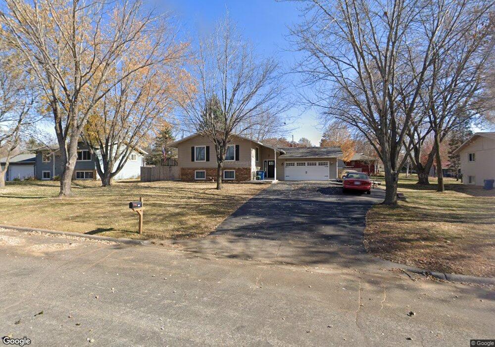
1018 10th Ave N Sauk Rapids, MN 56379
Estimated Value: $278,580 - $295,000
4
Beds
1
Bath
1,184
Sq Ft
$242/Sq Ft
Est. Value
About This Home
This home is located at 1018 10th Ave N, Sauk Rapids, MN 56379 and is currently estimated at $286,145, approximately $241 per square foot. 1018 10th Ave N is a home located in Benton County with nearby schools including Pleasant View Elementary School, Sauk Rapids-Rice Middle School, and Sauk Rapids-Rice Senior High School.
Ownership History
Date
Name
Owned For
Owner Type
Purchase Details
Closed on
Oct 13, 2021
Sold by
Ryan Donna R and Ryan Gary Francis
Bought by
Ogaard Daniel R
Current Estimated Value
Home Financials for this Owner
Home Financials are based on the most recent Mortgage that was taken out on this home.
Original Mortgage
$127,000
Outstanding Balance
$97,592
Interest Rate
2.1%
Mortgage Type
New Conventional
Estimated Equity
$188,553
Purchase Details
Closed on
Apr 28, 2017
Sold by
Frank Douglas D and Frank Kimberly A
Bought by
Ogaard Daniel R and Ryan Donna R
Home Financials for this Owner
Home Financials are based on the most recent Mortgage that was taken out on this home.
Original Mortgage
$157
Interest Rate
4.14%
Mortgage Type
Purchase Money Mortgage
Create a Home Valuation Report for This Property
The Home Valuation Report is an in-depth analysis detailing your home's value as well as a comparison with similar homes in the area
Home Values in the Area
Average Home Value in this Area
Purchase History
| Date | Buyer | Sale Price | Title Company |
|---|---|---|---|
| Ogaard Daniel R | -- | First American Title Ins Co | |
| Ogaard Daniel R | -- | None Available |
Source: Public Records
Mortgage History
| Date | Status | Borrower | Loan Amount |
|---|---|---|---|
| Open | Ogaard Daniel R | $127,000 | |
| Closed | Ogaard Daniel R | $157 |
Source: Public Records
Tax History Compared to Growth
Tax History
| Year | Tax Paid | Tax Assessment Tax Assessment Total Assessment is a certain percentage of the fair market value that is determined by local assessors to be the total taxable value of land and additions on the property. | Land | Improvement |
|---|---|---|---|---|
| 2025 | $2,840 | $253,100 | $31,800 | $221,300 |
| 2024 | $2,822 | $241,800 | $31,800 | $210,000 |
| 2023 | $2,680 | $244,600 | $31,800 | $212,800 |
| 2022 | $2,500 | $215,300 | $28,900 | $186,400 |
| 2021 | $2,278 | $186,300 | $28,900 | $157,400 |
| 2018 | $1,740 | $129,400 | $23,527 | $105,873 |
| 2017 | $1,740 | $103,900 | $22,304 | $81,596 |
| 2016 | $1,706 | $127,300 | $27,800 | $99,500 |
| 2015 | $1,712 | $93,300 | $21,651 | $71,649 |
| 2014 | -- | $84,300 | $21,018 | $63,282 |
| 2013 | -- | $85,700 | $21,121 | $64,579 |
Source: Public Records
Map
Nearby Homes
- 1101 10th Ave N
- 1107 10th Ave N
- 1105 Summit Ave N
- 216 8th Ave N
- 1201 10th Ave N
- 752 12th St N
- 117 6th Ave N
- 1406 Summit Ave N
- 615 3rd Ave N
- 224 9th St N
- 314 Pleasant Ridge Dr
- 112 Summit Ave S
- 100 9th Ave S
- XXXX Golden Spike Rd NE
- 1809 Eastern Star Loop
- 880 Golden Spike Rd NE
- 1018 N Benton Dr
- 970 Golden Spike Rd NE
- 702 N Benton Dr
- 709 N Benton Dr
- 1024 10th Ave N
- 1010 10th Ave N
- 1025 11th Ave N
- 1009 11th Ave N
- 1030 10th Ave N
- 1031 11th Ave N
- 1002 10th Ave N
- 1001 1001 11th-Avenue-n
- 1001 11th Ave N
- 1015 10th Ave N
- 1011 10th Ave N
- 1027 10th Ave N
- 1005 10th Ave N
- 1033 10th Ave N
- 1040 10th Ave N
- 1037 11th St N
- 818 10th Ave N
- 1009 Benedict Dr
- 1015 Benedict Dr
- 1018 9th Ave N