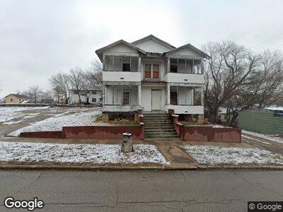
1018 Revard Ave Pawhuska, OK 74056
Estimated Value: $102,000
--
Bed
--
Bath
--
Sq Ft
1.5
Acres
About This Home
This home is located at 1018 Revard Ave, Pawhuska, OK 74056 and is currently estimated at $102,000. 1018 Revard Ave is a home located in Osage County with nearby schools including Indian Camp Elementary School, Pawhuska Elementary School, and Pawhuska Middle School.
Ownership History
Date
Name
Owned For
Owner Type
Purchase Details
Closed on
May 10, 2024
Sold by
Hopson Leah
Bought by
Roosevelt Zachary
Current Estimated Value
Purchase Details
Closed on
May 15, 2020
Sold by
Boe Valarie
Bought by
Hopson Leah
Purchase Details
Closed on
Jul 9, 2019
Sold by
State Of Oklahoma
Bought by
Boe Valarie
Purchase Details
Closed on
Sep 19, 2014
Sold by
Gambill Bruce W and Gambill Patricia R
Bought by
Miles Martin and Trona H-W
Purchase Details
Closed on
Feb 28, 2003
Sold by
Brace Jeff and Debbie H-W
Bought by
Clement Jeff and Faiith H-W
Purchase Details
Closed on
Sep 6, 2001
Sold by
Gambill Bruce W and Gambill Patricia R
Bought by
Brace Jeff and Brace Debbie
Create a Home Valuation Report for This Property
The Home Valuation Report is an in-depth analysis detailing your home's value as well as a comparison with similar homes in the area
Home Values in the Area
Average Home Value in this Area
Purchase History
| Date | Buyer | Sale Price | Title Company |
|---|---|---|---|
| Roosevelt Zachary | $9,000 | None Listed On Document | |
| Hopson Leah | $2,000 | None Available | |
| Boe Valarie | $235 | None Available | |
| Miles Martin | $1,000 | -- | |
| Clement Jeff | $25,000 | -- | |
| Brace Jeff | $25,000 | -- |
Source: Public Records
Tax History Compared to Growth
Tax History
| Year | Tax Paid | Tax Assessment Tax Assessment Total Assessment is a certain percentage of the fair market value that is determined by local assessors to be the total taxable value of land and additions on the property. | Land | Improvement |
|---|---|---|---|---|
| 2024 | $118 | $1,276 | $676 | $600 |
| 2023 | $118 | $1,276 | $676 | $600 |
| 2022 | $114 | $1,276 | $676 | $600 |
| 2021 | $114 | $1,276 | $676 | $600 |
| 2020 | $116 | $1,276 | $676 | $600 |
| 2019 | $113 | $0 | $0 | $0 |
| 2018 | $113 | $1,276 | $676 | $600 |
| 2017 | $115 | $1,276 | $676 | $600 |
| 2016 | $126 | $1,396 | $676 | $720 |
| 2015 | $130 | $1,396 | $676 | $720 |
| 2014 | $178 | $1,876 | $676 | $1,200 |
| 2013 | $178 | $1,876 | $676 | $1,200 |
Source: Public Records
Map
Nearby Homes
- 312 E 11th St
- 215 E 11th St
- 0 Prudom Ave
- 320 E 8th St
- 905 Leahy Ave
- 720 E 11th St
- 403 E 6th St
- 225 E 6th St
- 109 E 14th St
- 411 E Main St
- 1610 Grandview Ave
- 1700 Grandview Ave
- 1715 Grandview Ave
- 1815 Grandview Ave
- 1721 Bighill Ave
- 501 W 17th St
- 2019 Mckenzie Rd
- 705 Palmer Ave
- 2125 Mckenzie Rd
- 00000 Skyline Dr