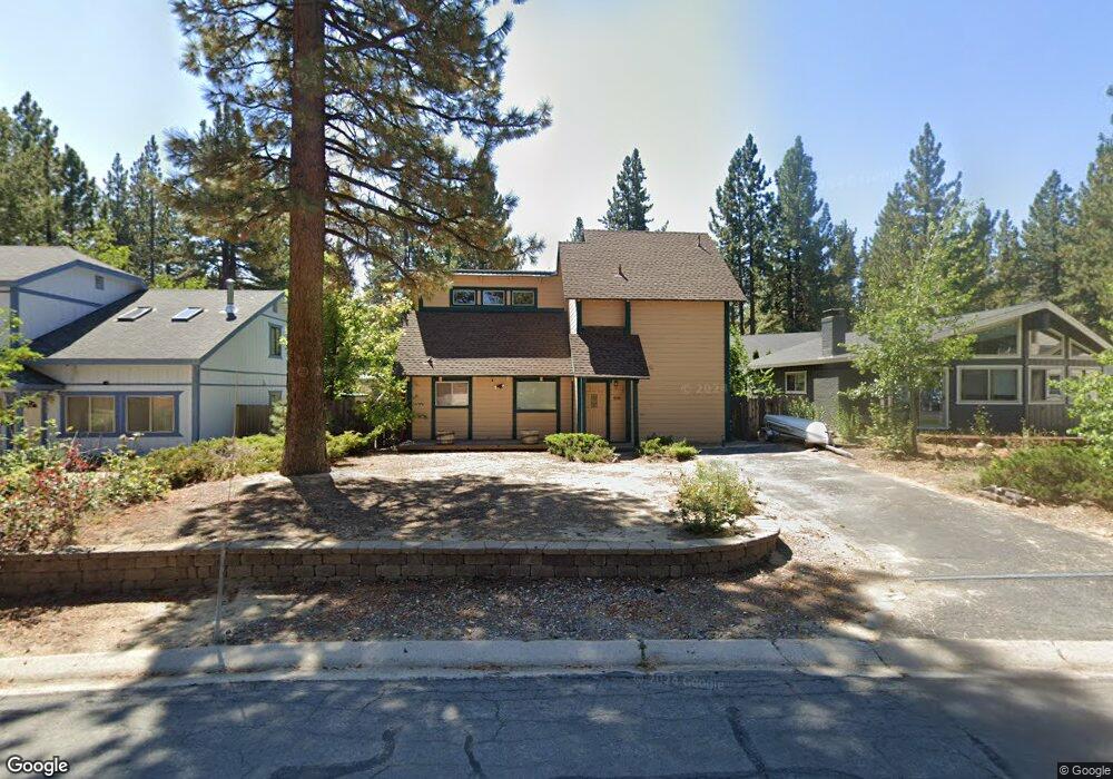
1018 Silverwood Cir South Lake Tahoe, CA 96150
Estimated Value: $518,000 - $653,000
3
Beds
2
Baths
1,212
Sq Ft
$481/Sq Ft
Est. Value
About This Home
This home is located at 1018 Silverwood Cir, South Lake Tahoe, CA 96150 and is currently estimated at $582,425, approximately $480 per square foot. 1018 Silverwood Cir is a home located in El Dorado County with nearby schools including Tahoe Valley Elementary School, South Tahoe Middle School, and South Tahoe High School.
Ownership History
Date
Name
Owned For
Owner Type
Purchase Details
Closed on
Jun 23, 2008
Sold by
Castromayor Jose S and Castromayor Amay C
Bought by
Castromayor Jose S and Castromayor Amay C
Current Estimated Value
Purchase Details
Closed on
Oct 5, 1993
Sold by
Ziegler Michael D and Brandmeyer Randall K
Bought by
Castromayor Jose S and Castromayor Amay C
Home Financials for this Owner
Home Financials are based on the most recent Mortgage that was taken out on this home.
Original Mortgage
$95,000
Interest Rate
6.94%
Create a Home Valuation Report for This Property
The Home Valuation Report is an in-depth analysis detailing your home's value as well as a comparison with similar homes in the area
Home Values in the Area
Average Home Value in this Area
Purchase History
| Date | Buyer | Sale Price | Title Company |
|---|---|---|---|
| Castromayor Jose S | -- | None Available | |
| Castromayor Jose S | $145,000 | Placer Title Company |
Source: Public Records
Mortgage History
| Date | Status | Borrower | Loan Amount |
|---|---|---|---|
| Closed | Castromayor Jose S | $95,000 |
Source: Public Records
Tax History Compared to Growth
Tax History
| Year | Tax Paid | Tax Assessment Tax Assessment Total Assessment is a certain percentage of the fair market value that is determined by local assessors to be the total taxable value of land and additions on the property. | Land | Improvement |
|---|---|---|---|---|
| 2025 | $2,656 | $246,410 | $59,466 | $186,944 |
| 2024 | $2,656 | $241,579 | $58,300 | $183,279 |
| 2023 | $2,610 | $236,843 | $57,157 | $179,686 |
| 2022 | $2,585 | $232,200 | $56,037 | $176,163 |
| 2021 | $2,545 | $227,648 | $54,939 | $172,709 |
| 2020 | $2,509 | $225,315 | $54,376 | $170,939 |
| 2019 | $2,497 | $220,898 | $53,310 | $167,588 |
| 2018 | $2,442 | $216,567 | $52,265 | $164,302 |
| 2017 | $2,404 | $212,322 | $51,241 | $161,081 |
| 2016 | $2,356 | $208,160 | $50,237 | $157,923 |
| 2015 | $2,237 | $205,035 | $49,484 | $155,551 |
| 2014 | $2,237 | $201,020 | $48,515 | $152,505 |
Source: Public Records
Map
Nearby Homes
- 2948 Pinewood Dr
- 941 Silver Dollar Ave
- 923 Sagewood Dr
- 2605 Chris Ave
- 2634 Chris Ave
- 2602 William Ave
- 1078 Reno Ave
- 2337 Sky Meadows Ct
- 2525 Knox Ave
- 2539 Knox Ave
- 1116 Lindberg Ave
- 2293 Eloise Ave Unit D
- 783 Michael Ct Unit Share B
- 783 Michael Ct
- 2610 Knox Ave
- 1053 William Ave
- 1145 Sierra Blvd
- 20149 Highway 50
- 2561 Osborne Ave
- 2664 Knox Ave
- 1012 Silverwood Cir
- 1022 Silverwood Cir
- 909 Comstock Way
- 915 Comstock Way
- 1008 Silverwood Cir
- 1028 Silverwood Cir
- 1017 Silverwood Cir
- 1013 Silverwood Cir
- 1021 Silverwood Cir
- 1002 Silverwood Cir
- 921 Comstock Way
- 2779 Springwood Dr
- 1009 Silverwood Cir
- 2789 Springwood Dr
- 998 Silverwood Cir
- 2773 Springwood Dr
- 963 Springwood Ct
- 1003 Silverwood Cir
- 904 Comstock Way
- 929 Comstock Way