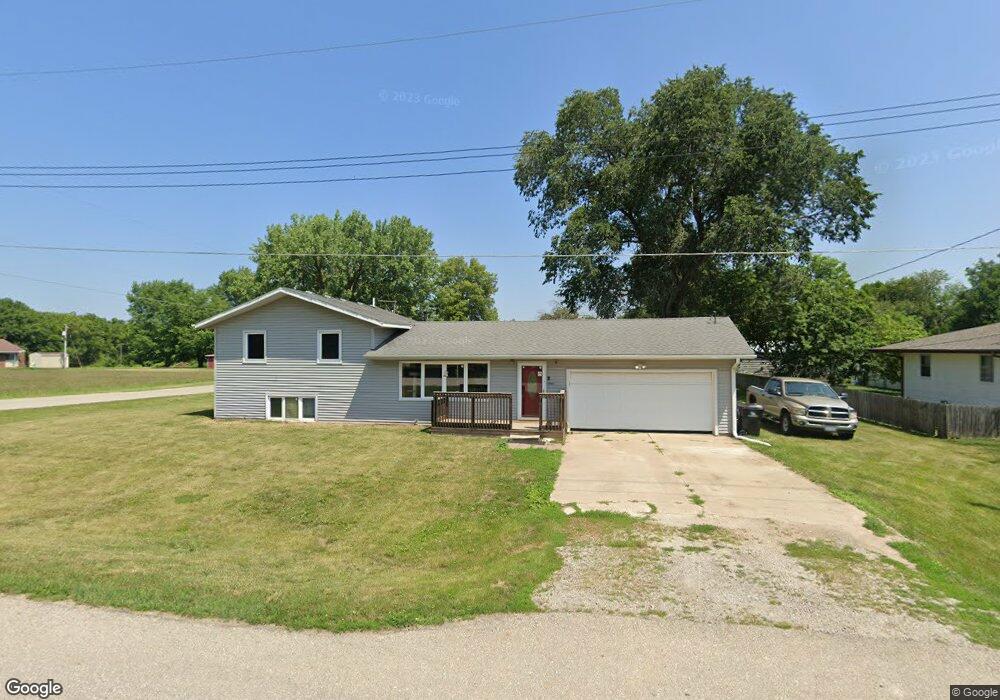
10188 S 34th Ave W Colfax, IA 50054
Estimated Value: $221,000 - $250,000
3
Beds
2
Baths
1,056
Sq Ft
$222/Sq Ft
Est. Value
About This Home
This home is located at 10188 S 34th Ave W, Colfax, IA 50054 and is currently estimated at $233,963, approximately $221 per square foot. 10188 S 34th Ave W is a home located in Jasper County with nearby schools including Colfax-Mingo Elementary School and Colfax-Mingo High School.
Ownership History
Date
Name
Owned For
Owner Type
Purchase Details
Closed on
Apr 23, 2007
Sold by
Lunders Laura
Bought by
Ekman Joel B and Ekman Lynnette
Current Estimated Value
Home Financials for this Owner
Home Financials are based on the most recent Mortgage that was taken out on this home.
Original Mortgage
$123,000
Outstanding Balance
$74,573
Interest Rate
6.2%
Mortgage Type
New Conventional
Estimated Equity
$159,390
Create a Home Valuation Report for This Property
The Home Valuation Report is an in-depth analysis detailing your home's value as well as a comparison with similar homes in the area
Home Values in the Area
Average Home Value in this Area
Purchase History
| Date | Buyer | Sale Price | Title Company |
|---|---|---|---|
| Ekman Joel B | $123,000 | None Available |
Source: Public Records
Mortgage History
| Date | Status | Borrower | Loan Amount |
|---|---|---|---|
| Open | Ekman Joel B | $123,000 |
Source: Public Records
Tax History Compared to Growth
Tax History
| Year | Tax Paid | Tax Assessment Tax Assessment Total Assessment is a certain percentage of the fair market value that is determined by local assessors to be the total taxable value of land and additions on the property. | Land | Improvement |
|---|---|---|---|---|
| 2025 | $2,618 | $219,430 | $29,040 | $190,390 |
| 2024 | $2,618 | $190,300 | $29,040 | $161,260 |
| 2023 | $2,538 | $190,300 | $29,040 | $161,260 |
| 2022 | $2,252 | $149,710 | $29,040 | $120,670 |
| 2021 | $2,340 | $146,940 | $29,040 | $117,900 |
| 2020 | $2,340 | $140,970 | $27,090 | $113,880 |
| 2019 | $2,170 | $120,900 | $0 | $0 |
| 2018 | $2,170 | $120,900 | $0 | $0 |
| 2017 | $2,178 | $120,900 | $0 | $0 |
| 2016 | $2,178 | $120,900 | $0 | $0 |
| 2015 | $2,176 | $119,670 | $0 | $0 |
| 2014 | $2,018 | $0 | $0 | $0 |
Source: Public Records
Map
Nearby Homes
- 1161 S Goodrich St
- 624 S Goodrich St
- 520 S Oak Park Ave
- 400 S Goodrich St
- 226 S Iowa St
- 222 E Broadway St
- 20 S Oak Park Ave
- 655 E Division St
- 34 E Broadway St
- 0000 Lincoln St
- 108 S Walnut St
- 200 Jefferson St
- 215 W Spring St
- 119 W Washington St
- 223 W Broadway St
- 300 E Front St
- 108 N West St
- 501 W Broadway St
- 11213 Orchard Ave
- HWY 117 at Intersection of Fleet Ave
- 10176 S 34th Ave W
- 10191 S 34th Ave W
- 10166 S 34th Ave W
- 10173 S 34th Ave W
- 3474 S Goodrich St
- 3453 S Goodrich St
- 3376 Goodrich St
- 3376 Goodrich St
- 10154 S 34th Ave W
- 10161 S 34th Ave W
- 1020 S Goodrich St
- 10142 S 34th Ave W
- 3327 Goodrich St
- 10145 S 34th Ave W
- 1040 S Goodrich St
- 1040 S Goodrich St Unit A
- 10126 S 34th Ave W
- 10131 S 34th Ave W
- 10242 S 35th Ave W
- 1044 S Goodrich St