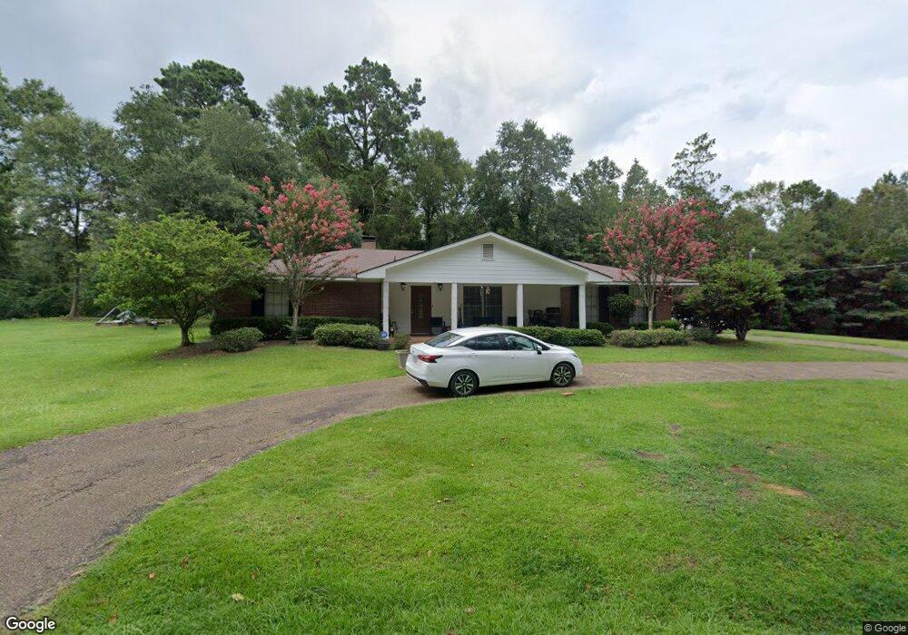
1019 Longleaf Rd McComb, MS 39648
Estimated Value: $210,642 - $261,000
Studio
--
Bath
2,517
Sq Ft
$91/Sq Ft
Est. Value
About This Home
This home is located at 1019 Longleaf Rd, McComb, MS 39648 and is currently estimated at $228,161, approximately $90 per square foot. 1019 Longleaf Rd is a home with nearby schools including Otken Elementary School, Higgins Middle School, and Denman Junior High School.
Ownership History
Date
Name
Owned For
Owner Type
Purchase Details
Closed on
Dec 10, 2021
Sold by
Renee Blalock and Renee Jana
Bought by
Robinson Tyrone Christopher
Current Estimated Value
Home Financials for this Owner
Home Financials are based on the most recent Mortgage that was taken out on this home.
Original Mortgage
$171,830
Outstanding Balance
$157,778
Interest Rate
3.14%
Mortgage Type
FHA
Estimated Equity
$70,383
Purchase Details
Closed on
Dec 22, 2020
Sold by
Roberts Marty and Roberts Marilyn
Bought by
Blalock Bradley and Blalock Jana Renee
Home Financials for this Owner
Home Financials are based on the most recent Mortgage that was taken out on this home.
Original Mortgage
$136,000
Interest Rate
2.7%
Mortgage Type
New Conventional
Create a Home Valuation Report for This Property
The Home Valuation Report is an in-depth analysis detailing your home's value as well as a comparison with similar homes in the area
Purchase History
| Date | Buyer | Sale Price | Title Company |
|---|---|---|---|
| Robinson Tyrone Christopher | -- | Law Pllc | |
| Blalock Bradley | -- | None Available |
Source: Public Records
Mortgage History
| Date | Status | Borrower | Loan Amount |
|---|---|---|---|
| Open | Robinson Tyrone Christopher | $171,830 | |
| Previous Owner | Blalock Bradley | $136,000 |
Source: Public Records
Tax History
| Year | Tax Paid | Tax Assessment Tax Assessment Total Assessment is a certain percentage of the fair market value that is determined by local assessors to be the total taxable value of land and additions on the property. | Land | Improvement |
|---|---|---|---|---|
| 2025 | $3,203 | $18,008 | $0 | $0 |
| 2024 | $2,790 | $15,626 | $0 | $0 |
| 2023 | $2,759 | $15,626 | $0 | $0 |
| 2022 | $2,720 | $15,626 | $0 | $0 |
| 2021 | $1,508 | $10,417 | $0 | $0 |
| 2020 | $1,581 | $10,838 | $0 | $0 |
| 2019 | $1,500 | $10,838 | $0 | $0 |
| 2018 | $1,447 | $10,838 | $0 | $0 |
| 2017 | $1,448 | $10,782 | $0 | $0 |
| 2016 | $1,435 | $10,782 | $0 | $0 |
| 2015 | -- | $10,981 | $0 | $0 |
| 2014 | -- | $10,981 | $0 | $0 |
| 2013 | -- | $10,981 | $0 | $0 |
Source: Public Records
Map
Nearby Homes
- 0000 Mississippi 570
- 111 Cedar Ridge Rd
- 1005 Northwest Ave
- 000 Pike Point Place
- 1600 Christine Dr
- 912 Laird St
- 917 North St
- 1004 Hickory Ave
- 212 Harmony St
- 213 Harmony St
- 0 Franklin St
- 515 Lakeview Ave
- 510 Lakeview Ave
- 900 N James Ave
- 804 North St
- 427 Lakeview Ave
- 1018 Park St
- 000 Rawls & White St
- 2062 &2063 Lazy Creek Rd
- 108 Pointe Dr
- 0 Long Leaf Dr
- 1020 Lloyd Stille Rd
- XXX Lloyd Stille Rd
- 1005 Lloyd Stille Rd
- 1025 Lloyd Stille Rd
- 1023 Lloyd Stille Rd
- 1027 Lloyd Stille Rd
- 303 A Mall Dr
- 1059 U S 51
- 303A Mall Dr
- 1008 Wallace Rd
- 1059 Highway 98 and 51
- 1059 Highway 98 and 51
- 1035 Highway 98 and 51
- XXX Wallace Dr & Lloyd Stille Rd
- 0 Mall Dr Unit 20600445
- 0 Mall Dr Unit 128763
- 0 Mall Dr Unit 111662
- 0 Mall Dr Unit 108909
- 0 Mall Dr Unit 107696
Your Personal Tour Guide
Ask me questions while you tour the home.