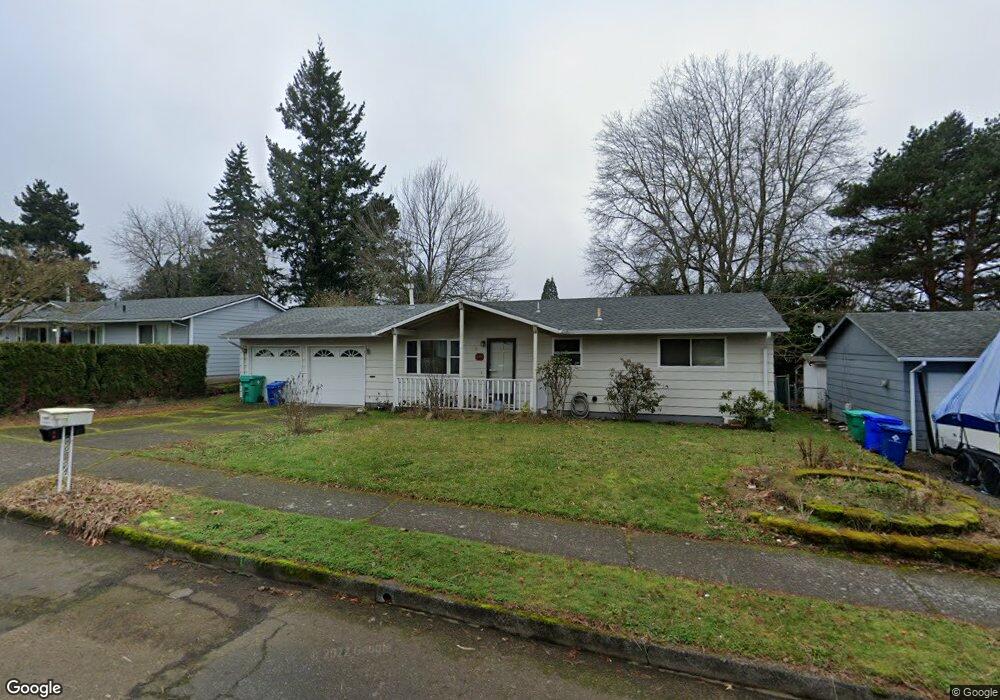
1019 SE 210th Ave Gresham, OR 97030
North Central NeighborhoodEstimated Value: $363,485 - $405,000
2
Beds
1
Bath
858
Sq Ft
$451/Sq Ft
Est. Value
About This Home
This home is located at 1019 SE 210th Ave, Gresham, OR 97030 and is currently estimated at $386,871, approximately $450 per square foot. 1019 SE 210th Ave is a home located in Multnomah County with nearby schools including North Gresham Elementary School, Clear Creek Middle School, and Gresham High School.
Ownership History
Date
Name
Owned For
Owner Type
Purchase Details
Closed on
Aug 13, 2003
Sold by
Urback Tina M
Bought by
Portis Jennifer M
Current Estimated Value
Home Financials for this Owner
Home Financials are based on the most recent Mortgage that was taken out on this home.
Original Mortgage
$116,000
Outstanding Balance
$49,429
Interest Rate
5.29%
Mortgage Type
Purchase Money Mortgage
Estimated Equity
$337,442
Purchase Details
Closed on
Jan 15, 1998
Sold by
Tipton Mark Dewvohn
Bought by
Urback Christopher J and Urback Tina M
Home Financials for this Owner
Home Financials are based on the most recent Mortgage that was taken out on this home.
Original Mortgage
$115,921
Interest Rate
7.13%
Mortgage Type
FHA
Create a Home Valuation Report for This Property
The Home Valuation Report is an in-depth analysis detailing your home's value as well as a comparison with similar homes in the area
Home Values in the Area
Average Home Value in this Area
Purchase History
| Date | Buyer | Sale Price | Title Company |
|---|---|---|---|
| Portis Jennifer M | $145,000 | Ticor Title Insurance Compan | |
| Urback Christopher J | $116,000 | Oregon Title Insurance Co |
Source: Public Records
Mortgage History
| Date | Status | Borrower | Loan Amount |
|---|---|---|---|
| Open | Portis Jennifer M | $116,000 | |
| Previous Owner | Urback Christopher J | $115,921 | |
| Closed | Portis Jennifer M | $21,750 |
Source: Public Records
Tax History
| Year | Tax Paid | Tax Assessment Tax Assessment Total Assessment is a certain percentage of the fair market value that is determined by local assessors to be the total taxable value of land and additions on the property. | Land | Improvement |
|---|---|---|---|---|
| 2025 | $3,561 | $174,990 | -- | -- |
| 2024 | $3,409 | $169,900 | -- | -- |
| 2023 | $3,106 | $164,960 | $0 | $0 |
| 2022 | $3,019 | $160,160 | $0 | $0 |
| 2021 | $2,943 | $155,500 | $0 | $0 |
| 2020 | $2,769 | $150,980 | $0 | $0 |
| 2019 | $2,697 | $146,590 | $0 | $0 |
| 2018 | $2,572 | $142,330 | $0 | $0 |
| 2017 | $2,467 | $138,190 | $0 | $0 |
| 2016 | $2,175 | $134,170 | $0 | $0 |
Source: Public Records
Map
Nearby Homes
- 1026 SE 209th Ave
- 21001 SE Yamhill St
- 1208 SE 209th Ave
- 21016 SE Stark St Unit 71
- 21016 SE Stark St Unit 69
- 2013 NW Bella Vista Dr
- 21260 SE Stark St
- 920 SE 214th Ave
- 21400 SE Stark St Unit 2
- 1711 NW 19th St
- 209 SE 214th Ave
- 1758 NW 18th Ct
- 21525 SE Oak St
- 132 SE 214th Ave
- 19776 SE Stark St Unit 147
- 0 SE Burnside St
- 805 SE 197th Ave
- 131 NE 201st Ave
- 1387 NW Riverview Ave Unit 14B
- 1035 SE 225th Ave
- 1003 SE 210th Ave
- 1101 SE 210th Ave
- 905 SE 210th Ave
- 1115 SE 210th Ave
- 1004 SE 209th Ave
- 1002 SE 210th Ave
- 1022 SE 210th Ave
- 1108 SE 210th Ave
- 19195 SE Yamhill St Unit 2
- 19189 SE Yamhill St Unit 8
- 19183 SE Yamhill St Unit 9
- 19195 SE Yamhill St Unit 7
- 19195 SE Yamhill St Unit 1
- 19183 SE Yamhill St Unit 11
- 19195 SE Yamhill St Unit 4
- 19183 SE Yamhill St Unit 10
- 19195 SE Yamhill St Unit 3
- 835 SE 210th Ave
- 1127 SE 210th Ave
- 824 SE 209th Ave
Your Personal Tour Guide
Ask me questions while you tour the home.