Estimated Value: $223,000 - $240,000
3
Beds
2
Baths
1,176
Sq Ft
$197/Sq Ft
Est. Value
About This Home
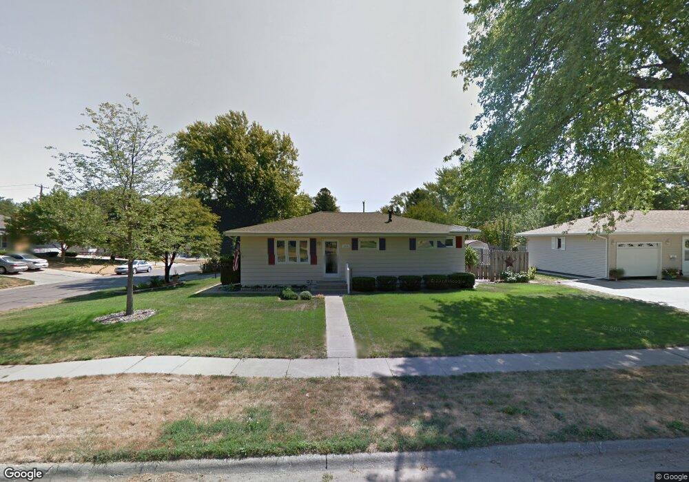
This home is located at 1019 Sherman St, Wayne, NE 68787 and is currently estimated at $231,245, approximately $196 per square foot. 1019 Sherman St is a home located in Wayne County with nearby schools including Wayne Elementary School, Wayne High School, and St. Mary Elementary School.
Ownership History
Date
Name
Owned For
Owner Type
Purchase Details
Closed on
Apr 9, 2024
Sold by
Elypse Donald L and Hypse Theresa M
Bought by
Scott Colton T and Scott Jessica N
Current Estimated Value
Home Financials for this Owner
Home Financials are based on the most recent Mortgage that was taken out on this home.
Original Mortgage
$218,500
Outstanding Balance
$215,229
Interest Rate
6.87%
Mortgage Type
New Conventional
Estimated Equity
$16,016
Purchase Details
Closed on
Aug 5, 2021
Sold by
Hypse Donald L and Hypse Theresa
Bought by
Hypse Donald L and Hypse Theresa
Create a Home Valuation Report for This Property
The Home Valuation Report is an in-depth analysis detailing your home's value as well as a comparison with similar homes in the area
Home Values in the Area
Average Home Value in this Area
Purchase History
| Date | Buyer | Sale Price | Title Company |
|---|---|---|---|
| Scott Colton T | $230,000 | Madison County Abstract | |
| Hypse Donald L | -- | None Listed On Document |
Source: Public Records
Mortgage History
| Date | Status | Borrower | Loan Amount |
|---|---|---|---|
| Open | Scott Colton T | $218,500 |
Source: Public Records
Tax History
| Year | Tax Paid | Tax Assessment Tax Assessment Total Assessment is a certain percentage of the fair market value that is determined by local assessors to be the total taxable value of land and additions on the property. | Land | Improvement |
|---|---|---|---|---|
| 2025 | $2,302 | $202,135 | $9,845 | $192,290 |
| 2024 | $2,302 | $182,055 | $9,235 | $172,820 |
| 2023 | $2,813 | $165,405 | $9,235 | $156,170 |
| 2022 | $2,439 | $139,795 | $9,235 | $130,560 |
| 2021 | $2,179 | $119,490 | $9,235 | $110,255 |
| 2020 | $1,919 | $107,255 | $9,235 | $98,020 |
| 2019 | $1,892 | $107,255 | $9,235 | $98,020 |
| 2018 | $1,748 | $97,485 | $9,235 | $88,250 |
| 2017 | $1,728 | $97,485 | $9,235 | $88,250 |
| 2016 | $1,827 | $0 | $0 | $0 |
| 2015 | $1,786 | $97,485 | $9,235 | $88,250 |
| 2014 | -- | $97,485 | $9,235 | $88,250 |
| 2013 | -- | $97,485 | $9,235 | $88,250 |
Source: Public Records
Map
Nearby Homes
- 415 W 11th St
- 1017 Sherman St
- 1013 Sherman St
- 418 W 11th St
- 504 Fairacres Rd
- 416 W 11th St
- 1011 Sherman St
- 1036 Douglas St
- 410 W 11th St
- 1012 Sherman St
- 1022 Douglas St
- 1106 Sherman St
- 1009 Sherman St
- 510 Fairacres Rd
- 1115 Sherman St
- 1014 Douglas St
- 1016 Douglas St
- 404 W 11th St
- 509 Crescent Dr
- 1008 Sherman St
Your Personal Tour Guide
Ask me questions while you tour the home.