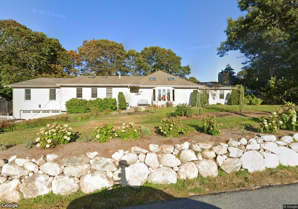
102 4th Ave Hyannis, MA 2601
Estimated Value: $884,000 - $1,133,000
4
Beds
2
Baths
2,816
Sq Ft
$378/Sq Ft
Est. Value
About This Home
This home is located at 102 4th Ave, Hyannis, MA 2601 and is currently estimated at $1,063,395, approximately $377 per square foot. 102 4th Ave is a home located in Barnstable County with nearby schools including Hyannis West Elementary School, Barnstable United Elementary School, and Barnstable Intermediate School.
Ownership History
Date
Name
Owned For
Owner Type
Purchase Details
Closed on
Sep 19, 2022
Sold by
Ninivaggi Anthony and Ninivaggi Carolyn
Bought by
Ninivaggi Ft
Current Estimated Value
Purchase Details
Closed on
Jun 29, 1989
Sold by
Hanlon Thomas H
Bought by
Ninivaggi Anthony
Home Financials for this Owner
Home Financials are based on the most recent Mortgage that was taken out on this home.
Original Mortgage
$110,000
Interest Rate
10.56%
Mortgage Type
Purchase Money Mortgage
Create a Home Valuation Report for This Property
The Home Valuation Report is an in-depth analysis detailing your home's value as well as a comparison with similar homes in the area
Home Values in the Area
Average Home Value in this Area
Purchase History
| Date | Buyer | Sale Price | Title Company |
|---|---|---|---|
| Ninivaggi Ft | -- | None Available | |
| Ninivaggi Anthony | $161,000 | -- | |
| Ninivaggi Anthony | $161,000 | -- |
Source: Public Records
Mortgage History
| Date | Status | Borrower | Loan Amount |
|---|---|---|---|
| Previous Owner | Ninivaggi Anthony | $43,000 | |
| Previous Owner | Ninivaggi Anthony | $110,000 | |
| Previous Owner | Ninivaggi Anthony | $110,000 |
Source: Public Records
Tax History Compared to Growth
Tax History
| Year | Tax Paid | Tax Assessment Tax Assessment Total Assessment is a certain percentage of the fair market value that is determined by local assessors to be the total taxable value of land and additions on the property. | Land | Improvement |
|---|---|---|---|---|
| 2025 | $8,857 | $955,500 | $329,200 | $626,300 |
| 2024 | $8,125 | $897,800 | $329,200 | $568,600 |
| 2023 | $7,330 | $765,900 | $306,100 | $459,800 |
| 2022 | $7,060 | $610,200 | $211,600 | $398,600 |
| 2021 | $6,614 | $555,300 | $231,800 | $323,500 |
| 2020 | $6,784 | $550,200 | $231,800 | $318,400 |
| 2019 | $6,528 | $518,900 | $241,800 | $277,100 |
| 2018 | $5,830 | $474,000 | $243,900 | $230,100 |
| 2017 | $5,539 | $462,000 | $243,900 | $218,100 |
| 2016 | $5,438 | $463,600 | $245,500 | $218,100 |
| 2015 | $4,289 | $370,700 | $159,300 | $211,400 |
Source: Public Records
Map
Nearby Homes