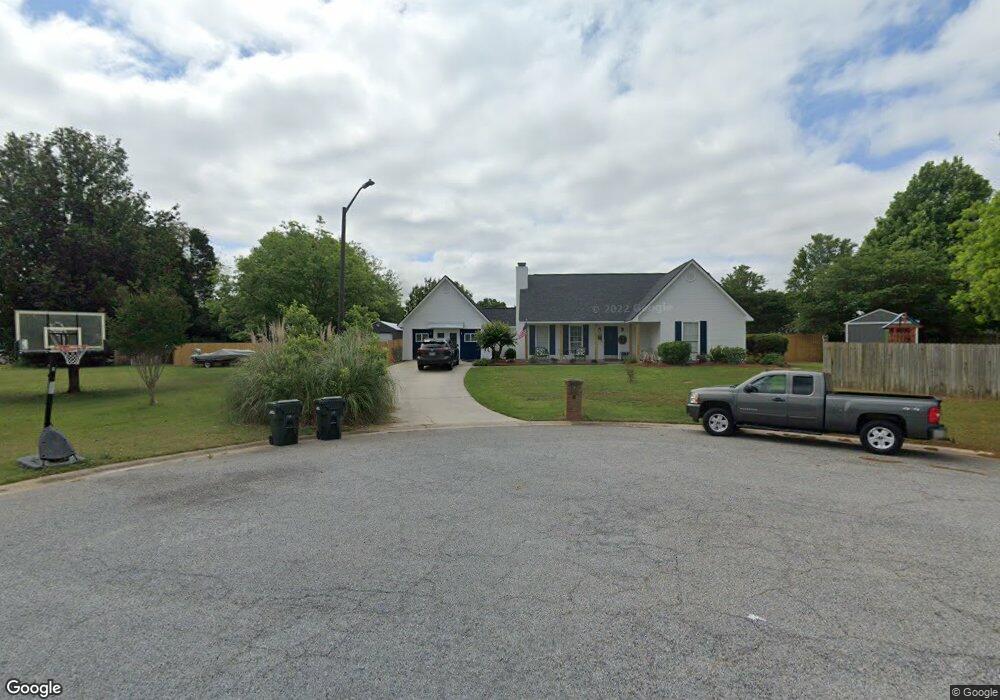
102 Alan Albert Ct Warner Robins, GA 31088
Estimated Value: $236,285 - $249,000
Studio
1
Bath
1,845
Sq Ft
$132/Sq Ft
Est. Value
About This Home
This home is located at 102 Alan Albert Ct, Warner Robins, GA 31088 and is currently estimated at $243,821, approximately $132 per square foot. 102 Alan Albert Ct is a home located in Houston County with nearby schools including Lake Joy Primary School, Lake Joy Elementary School, and Feagin Mill Middle School.
Ownership History
Date
Name
Owned For
Owner Type
Purchase Details
Closed on
Dec 3, 1999
Sold by
Secretary Of Hs & Urban Dev
Bought by
Jernigan Vincent T and Jernigan Janet D
Current Estimated Value
Purchase Details
Closed on
Jun 1, 1999
Sold by
Homeside Lending Inc
Bought by
Secretary Of Hs & Urban Dev
Purchase Details
Closed on
Oct 24, 1996
Sold by
Casale Philip P
Bought by
Casale Philip P and Valerie J*
Create a Home Valuation Report for This Property
The Home Valuation Report is an in-depth analysis detailing your home's value as well as a comparison with similar homes in the area
Home Values in the Area
Average Home Value in this Area
Purchase History
| Date | Buyer | Sale Price | Title Company |
|---|---|---|---|
| Jernigan Vincent T | $85,000 | -- | |
| Secretary Of Hs & Urban Dev | -- | -- | |
| Homeside Lending Inc | -- | -- | |
| Casale Philip P | -- | -- | |
| Casale Philip P | $88,500 | -- |
Source: Public Records
Tax History
| Year | Tax Paid | Tax Assessment Tax Assessment Total Assessment is a certain percentage of the fair market value that is determined by local assessors to be the total taxable value of land and additions on the property. | Land | Improvement |
|---|---|---|---|---|
| 2025 | $1,745 | $79,880 | $10,800 | $69,080 |
| 2024 | $1,621 | $67,760 | $9,600 | $58,160 |
| 2023 | $1,506 | $62,320 | $9,000 | $53,320 |
| 2022 | $1,442 | $59,680 | $9,000 | $50,680 |
| 2021 | $1,240 | $51,040 | $9,000 | $42,040 |
| 2020 | $1,155 | $47,320 | $9,000 | $38,320 |
| 2019 | $1,155 | $47,320 | $9,000 | $38,320 |
| 2018 | $1,087 | $44,520 | $9,000 | $35,520 |
| 2017 | $1,088 | $44,520 | $9,000 | $35,520 |
| 2016 | $1,089 | $44,520 | $9,000 | $35,520 |
| 2015 | $1,092 | $44,520 | $9,000 | $35,520 |
| 2014 | -- | $44,520 | $9,000 | $35,520 |
| 2013 | -- | $44,520 | $9,000 | $35,520 |
Source: Public Records
Map
Nearby Homes
- 108 Musket Fire Ln
- 105 White Pond Ln
- 102 Stonemill Dr
- 1124 Panola Cir
- 211 Buckhead Forest Dr
- 209 Buckhead Forest Dr
- 101 Bay Laurel Cir
- 120 Country Walk
- 109 Erin Lee Ct
- 218 Knob Hill Dr
- 319 Tyson Glen Dr
- 104 Trotters Ct
- 302 Estates Way
- 111 Ellice Ct
- 316 Haverhill Cir
- 108 Havelock Cir
- 113 Jana Ct
- 504 Haverhill Cir
- 0 Feagin Mill Rd Unit 10572748
- 0 Feagin Mill Rd Unit 254957
- 213 Settlers Trail
- 103 Alan Albert Ct
- 211 Settler's Trail
- 211 Settlers Trail
- 106 Musket Fire Ln
- 215 Settlers Trail
- 217 Settlers Trail
- 101 Alan Albert Ct
- 209 Settlers Trail
- 104 Musket Fire Ln
- 118 Musket Fire Ln
- 219 Settlers Trail
- 210 Settlers Trail
- 109 Musket Fire Ln
- 207 Settlers Trail
- 111 Musket Fire Ln
- 214 Settlers Trail
- 0 Dry Creek Ct
- 208 Settlers Trail
- 107 Musket Fire Ln
Your Personal Tour Guide
Ask me questions while you tour the home.