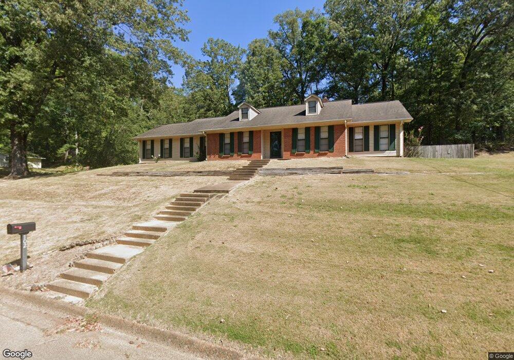
102 Forrest Hill Dr Grenada, MS 38901
Estimated Value: $224,000 - $253,000
3
Beds
3
Baths
2,504
Sq Ft
$94/Sq Ft
Est. Value
About This Home
This home is located at 102 Forrest Hill Dr, Grenada, MS 38901 and is currently estimated at $235,721, approximately $94 per square foot. 102 Forrest Hill Dr is a home located in Grenada County with nearby schools including Grenada Elementary School, Grenada Upper Elementary School, and Grenada Middle School.
Ownership History
Date
Name
Owned For
Owner Type
Purchase Details
Closed on
Oct 6, 2020
Sold by
Holland Ralph E and Holland Rachel M
Bought by
Conley Kendrick K and Conley Stephanie
Current Estimated Value
Home Financials for this Owner
Home Financials are based on the most recent Mortgage that was taken out on this home.
Original Mortgage
$174,775
Outstanding Balance
$153,740
Interest Rate
2.8%
Mortgage Type
FHA
Estimated Equity
$81,981
Purchase Details
Closed on
May 14, 2010
Sold by
Griffin
Bought by
Holland
Create a Home Valuation Report for This Property
The Home Valuation Report is an in-depth analysis detailing your home's value as well as a comparison with similar homes in the area
Purchase History
| Date | Buyer | Sale Price | Title Company |
|---|---|---|---|
| Conley Kendrick K | -- | None Available | |
| Holland | $156,500 | -- |
Source: Public Records
Mortgage History
| Date | Status | Borrower | Loan Amount |
|---|---|---|---|
| Open | Conley Kendrick K | $174,775 | |
| Previous Owner | Holland | $141,850 |
Source: Public Records
Tax History
| Year | Tax Paid | Tax Assessment Tax Assessment Total Assessment is a certain percentage of the fair market value that is determined by local assessors to be the total taxable value of land and additions on the property. | Land | Improvement |
|---|---|---|---|---|
| 2025 | $1,341 | $19,705 | $3,100 | $16,605 |
| 2024 | $14 | $16,283 | $3,100 | $13,183 |
| 2023 | $1,373 | $16,283 | $3,100 | $13,183 |
| 2022 | $1,368 | $16,283 | $3,100 | $13,183 |
| 2021 | $1,296 | $16,283 | $3,100 | $13,183 |
| 2020 | $1,487 | $15,188 | $3,100 | $12,088 |
| 2019 | $1,187 | $15,188 | $3,100 | $12,088 |
| 2018 | $1,171 | $15,188 | $3,100 | $12,088 |
| 2017 | $1,171 | $15,188 | $3,100 | $12,088 |
| 2016 | $1,116 | $14,625 | $0 | $0 |
| 2015 | $1,116 | $14,625 | $0 | $0 |
| 2014 | -- | $14,625 | $0 | $0 |
Source: Public Records
Map
Nearby Homes
- 325 Katherine Dr
- 461 Robin Rd
- 1289 South St
- 115 Doors
- 0 Ms-7 N
- Tract 2 U S Highway 51
- 0 U S Highway 51
- 1331 Sunset Dr
- 442 Margin St
- 0 Barbee St
- 371 S College St
- 649 Old Hickory Rd
- 366 Elm St
- 433 S Main St
- 16 Acres U S Highway 51 Unit 2
- 10 Acres U S Highway 51
- 11555 U S Highway 51
- 14 Acres U S Highway 51 Unit 3
- Home Portfolio 3 Door Grenada Ms
- 1240 Westview Cove
- 100 Forrest Hill Dr
- 102 Fort Dr
- 222 Forrest Hill Dr
- 101 Fort Dr
- 96 Forrest Hill Dr
- 292 Katherine Dr
- 276 Katherine Dr
- 221 Forrest Hill Dr
- 156 Fort Dr
- 105 Fort Dr
- 328 Katherine Dr
- 101 Forrest Hill Dr
- 260 Katherine Dr
- 272 Forrest Hill Dr
- 195 Gypsy Rd
- 291 Katherine Dr
- 330 Robin Rd
- 263 Katherine Dr
- 202 Fort Dr
- 348 Robin Rd
Your Personal Tour Guide
Ask me questions while you tour the home.