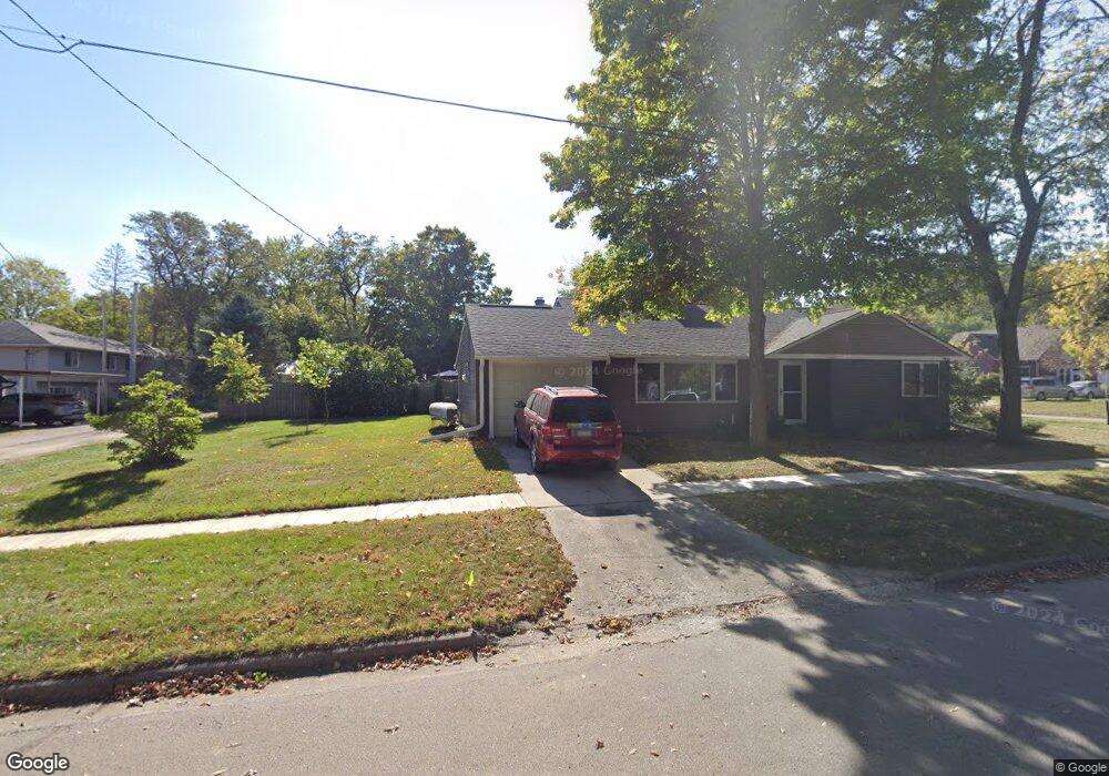
102 Mckinley St NW Elkader, IA 52043
Estimated Value: $135,000 - $203,000
3
Beds
2
Baths
1,348
Sq Ft
$120/Sq Ft
Est. Value
About This Home
This home is located at 102 Mckinley St NW, Elkader, IA 52043 and is currently estimated at $162,042, approximately $120 per square foot. 102 Mckinley St NW is a home located in Clayton County with nearby schools including Central Elementary School and Central Middle School/High School.
Ownership History
Date
Name
Owned For
Owner Type
Purchase Details
Closed on
Jan 28, 2021
Sold by
Pohlmann Lee J and Pohlmann Susan W
Bought by
Lee & Susan Pohlmann Trust
Current Estimated Value
Purchase Details
Closed on
Feb 12, 2020
Sold by
Walch Thomas W and Walch Lisa
Bought by
Pohlman Susan W and Pohlman Lee J
Home Financials for this Owner
Home Financials are based on the most recent Mortgage that was taken out on this home.
Original Mortgage
$72,000
Interest Rate
3.4%
Mortgage Type
New Conventional
Purchase Details
Closed on
Jun 5, 2014
Sold by
David Mary Anne
Bought by
David Mary Anne and The Mary Anne David Trust
Create a Home Valuation Report for This Property
The Home Valuation Report is an in-depth analysis detailing your home's value as well as a comparison with similar homes in the area
Home Values in the Area
Average Home Value in this Area
Purchase History
| Date | Buyer | Sale Price | Title Company |
|---|---|---|---|
| Lee & Susan Pohlmann Trust | -- | None Available | |
| Pohlman Susan W | -- | None Available | |
| David Mary Anne | -- | None Available |
Source: Public Records
Mortgage History
| Date | Status | Borrower | Loan Amount |
|---|---|---|---|
| Previous Owner | Pohlman Susan W | $72,000 |
Source: Public Records
Tax History Compared to Growth
Tax History
| Year | Tax Paid | Tax Assessment Tax Assessment Total Assessment is a certain percentage of the fair market value that is determined by local assessors to be the total taxable value of land and additions on the property. | Land | Improvement |
|---|---|---|---|---|
| 2025 | $3,134 | $147,834 | $14,573 | $133,261 |
| 2024 | $2,850 | $125,423 | $12,672 | $112,751 |
| 2023 | $2,598 | $125,423 | $12,672 | $112,751 |
| 2022 | $2,110 | $99,519 | $11,550 | $87,969 |
| 2021 | $1,910 | $87,279 | $11,550 | $75,729 |
| 2020 | $1,910 | $82,564 | $11,550 | $71,014 |
| 2019 | $1,788 | $82,564 | $11,550 | $71,014 |
| 2018 | $1,788 | $79,115 | $11,550 | $67,565 |
| 2017 | $1,848 | $79,115 | $11,550 | $67,565 |
| 2015 | $1,718 | $74,957 | $10,563 | $64,394 |
| 2014 | $1,618 | $74,957 | $10,563 | $64,394 |
Source: Public Records
Map
Nearby Homes
- 707 N Main St
- 702 N Main St
- 301 N 1st St
- 710 Woodland Dr NW
- 302 N 3rd St
- 117 S Main St
- 209 2nd St SW
- 0 E Bridge St
- 247 Franzen Ridge Rd
- 249 Franzen Ridge Rd
- 26642 Iowa 13
- 27766 Highway 13
- 0 13 Hwy Unit NBR20255145
- 14149 Iowa 56
- 27455 Harbor Rd
- TBD Country Rd
- 0 Grandview Rd
- 305 S Russell St
- TBD Birch Rd
- 100 Volga St