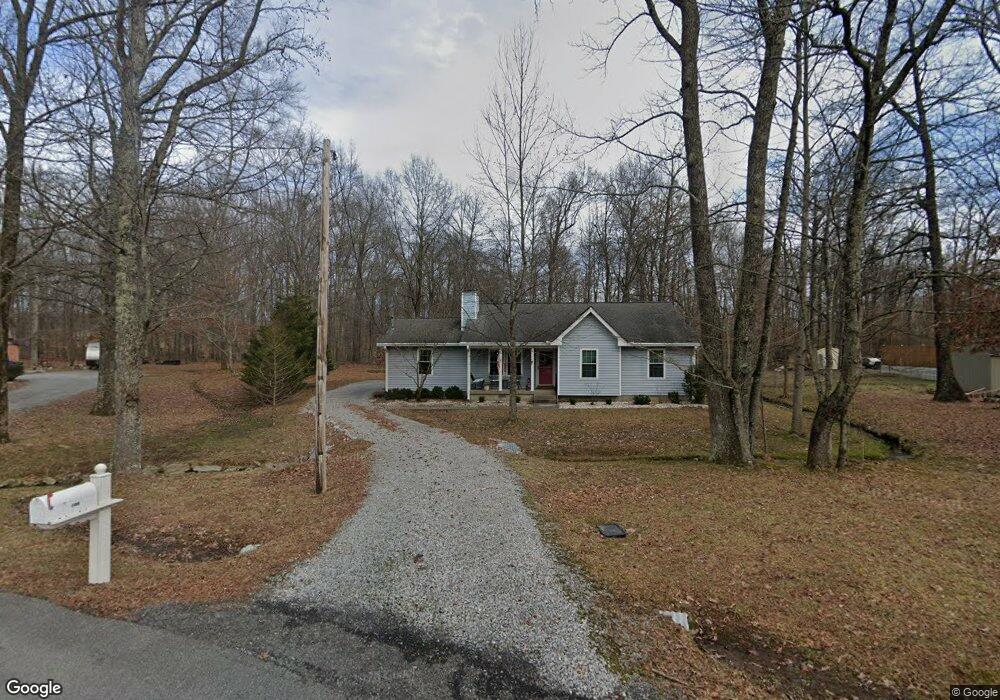
102 Rolling Forrest Ct White House, TN 37188
Estimated Value: $291,389 - $314,000
--
Bed
2
Baths
1,299
Sq Ft
$232/Sq Ft
Est. Value
About This Home
This home is located at 102 Rolling Forrest Ct, White House, TN 37188 and is currently estimated at $301,347, approximately $231 per square foot. 102 Rolling Forrest Ct is a home located in Sumner County with nearby schools including Harold B. Williams Elementary School, White House Middle School, and White House High School.
Ownership History
Date
Name
Owned For
Owner Type
Purchase Details
Closed on
Oct 3, 2017
Sold by
Speight Judith H
Bought by
Speight Judith H and Tulip Grovo Revocable Trust
Current Estimated Value
Purchase Details
Closed on
Oct 18, 2001
Sold by
Ramsey Lisa Kay
Bought by
Speight Judith H
Home Financials for this Owner
Home Financials are based on the most recent Mortgage that was taken out on this home.
Original Mortgage
$50,000
Interest Rate
6.87%
Purchase Details
Closed on
Sep 15, 1995
Sold by
Commercial Federal Mort
Bought by
Kay Ramsey Lisa
Create a Home Valuation Report for This Property
The Home Valuation Report is an in-depth analysis detailing your home's value as well as a comparison with similar homes in the area
Home Values in the Area
Average Home Value in this Area
Purchase History
| Date | Buyer | Sale Price | Title Company |
|---|---|---|---|
| Speight Judith H | -- | None Available | |
| Speight Judith H | $115,900 | Title Escrow Robertson Count | |
| Kay Ramsey Lisa | $84,995 | -- |
Source: Public Records
Mortgage History
| Date | Status | Borrower | Loan Amount |
|---|---|---|---|
| Closed | Speight Judith H | $50,000 |
Source: Public Records
Tax History Compared to Growth
Tax History
| Year | Tax Paid | Tax Assessment Tax Assessment Total Assessment is a certain percentage of the fair market value that is determined by local assessors to be the total taxable value of land and additions on the property. | Land | Improvement |
|---|---|---|---|---|
| 2024 | $697 | $74,525 | $23,750 | $50,775 |
| 2023 | $1,035 | $41,050 | $15,350 | $25,700 |
| 2022 | $1,035 | $41,050 | $15,350 | $25,700 |
| 2021 | $1,035 | $41,050 | $15,350 | $25,700 |
| 2020 | $1,035 | $41,050 | $15,350 | $25,700 |
| 2019 | $1,122 | $0 | $0 | $0 |
| 2018 | $1,035 | $0 | $0 | $0 |
| 2017 | $1,035 | $0 | $0 | $0 |
| 2016 | $697 | $0 | $0 | $0 |
| 2015 | -- | $0 | $0 | $0 |
| 2014 | -- | $0 | $0 | $0 |
Source: Public Records
Map
Nearby Homes
- 100 Rolling Acres Dr
- 110 Sycamore Dr
- 202 Hunterwood Dr
- 103 Cypress Ct
- 109 Chalone Dr
- 101 Chalone Dr
- 2724 Highway 31 W
- 125 Sycamore Dr
- 405 Hunterwood Dr
- 101 Laura Dr
- 1112 Southerlynn Dr
- 1128 Southerlynn Dr
- 1124 Southerlynn Dr
- 427 Fieldstone Dr
- 1136 Southerlynn Dr
- The Caldwell Plan at Marlin Pointe
- The Phoenix Plan at Marlin Pointe
- The Pearson Plan at Marlin Pointe
- The Braselton II Plan at Marlin Pointe
- 200 Sapphire Dr
- 104 Rolling Forrest Ct
- 402 Rolling Acres Dr
- 400 Rolling Acres Dr
- 106 Rolling Forrest Ct
- 103 Rolling Forrest Ct
- 105 Rolling Forrest Ct
- 302 Rolling Acres Dr
- 104 Forrest Ln
- 102 Forrest Ln
- 403 Rolling Acres Dr
- 401 Rolling Acres Dr
- 307 Rolling Acres Dr
- 106 Forrest Ln
- 300 Rolling Acres Dr
- 305 Rolling Acres Dr
- 303 Rolling Acres Dr
- 108 Forrest Ln
- 771 Mccurdy Rd
- 767 Mccurdy Rd
- 301 Rolling Acres Dr