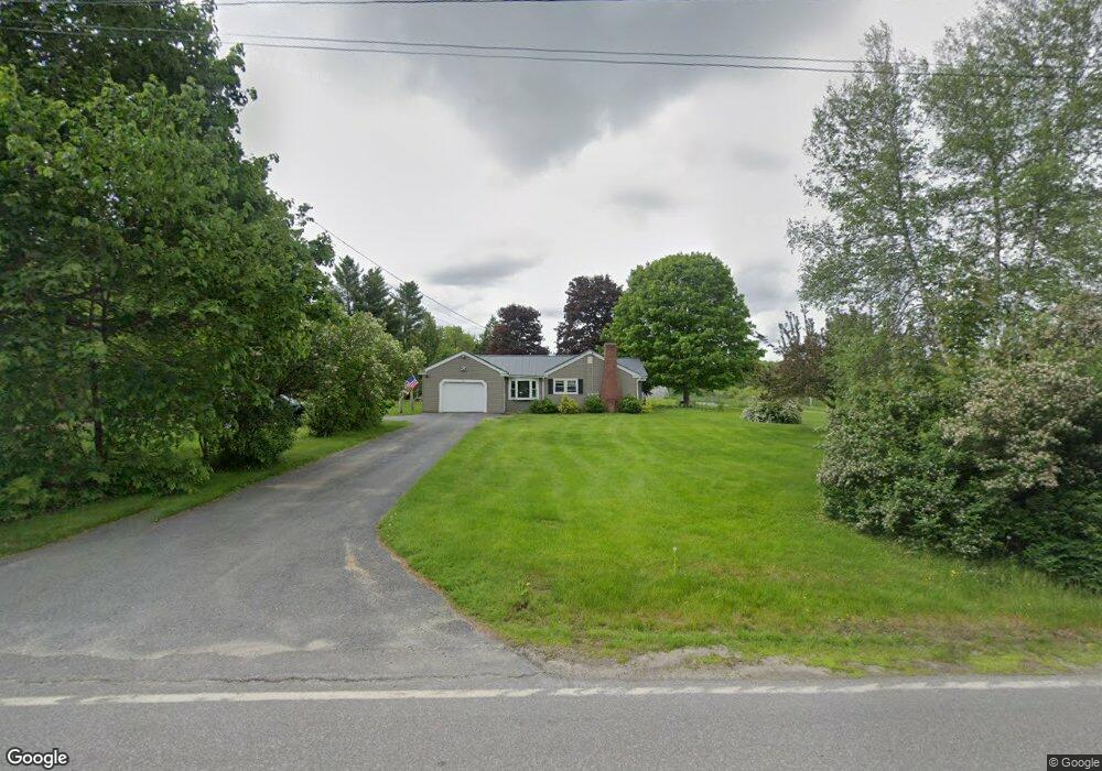
102 Vaughan Rd Farmingdale, ME 04344
Estimated Value: $230,705 - $343,000
--
Bed
--
Bath
--
Sq Ft
10
Acres
About This Home
This home is located at 102 Vaughan Rd, Farmingdale, ME 04344 and is currently estimated at $296,676. 102 Vaughan Rd is a home with nearby schools including Hall-Dale Elementary School, Dresden Elementary School, and Monmouth Memorial School.
Ownership History
Date
Name
Owned For
Owner Type
Purchase Details
Closed on
May 19, 2023
Sold by
E F & J J Mcpherson Irt and Mcpherson
Bought by
Donnell James and Hayes Kelly
Current Estimated Value
Home Financials for this Owner
Home Financials are based on the most recent Mortgage that was taken out on this home.
Original Mortgage
$223,250
Outstanding Balance
$216,428
Interest Rate
6.28%
Mortgage Type
Purchase Money Mortgage
Estimated Equity
$80,248
Purchase Details
Closed on
Dec 6, 2017
Sold by
Mcpherson Ernest F and Mcpherson Joan J
Bought by
Ernest F & J Mcpherson Irt and Mcpherson
Purchase Details
Closed on
Dec 6, 2010
Sold by
Mcpherson Ernest F and Mcpherson Joan
Bought by
Roy Colin A
Create a Home Valuation Report for This Property
The Home Valuation Report is an in-depth analysis detailing your home's value as well as a comparison with similar homes in the area
Home Values in the Area
Average Home Value in this Area
Purchase History
| Date | Buyer | Sale Price | Title Company |
|---|---|---|---|
| Donnell James | -- | None Available | |
| Ernest F & J Mcpherson Irt | -- | -- | |
| Roy Colin A | -- | -- | |
| Roy Colin A | -- | -- |
Source: Public Records
Mortgage History
| Date | Status | Borrower | Loan Amount |
|---|---|---|---|
| Open | Donnell James | $223,250 |
Source: Public Records
Tax History Compared to Growth
Tax History
| Year | Tax Paid | Tax Assessment Tax Assessment Total Assessment is a certain percentage of the fair market value that is determined by local assessors to be the total taxable value of land and additions on the property. | Land | Improvement |
|---|---|---|---|---|
| 2024 | $3,046 | $126,900 | $35,900 | $91,000 |
| 2023 | $2,830 | $126,900 | $35,900 | $91,000 |
| 2022 | $2,601 | $126,900 | $35,900 | $91,000 |
| 2021 | $2,208 | $126,900 | $35,900 | $91,000 |
| 2020 | $1,594 | $126,900 | $35,900 | $91,000 |
| 2019 | $2,176 | $126,900 | $35,900 | $91,000 |
| 2018 | $1,172 | $126,900 | $35,900 | $91,000 |
| 2017 | $1,946 | $126,900 | $35,900 | $91,000 |
| 2016 | $1,948 | $126,900 | $35,900 | $91,000 |
| 2015 | $1,808 | $126,900 | $35,900 | $91,000 |
| 2014 | $1,777 | $126,900 | $35,900 | $91,000 |
| 2013 | $1,675 | $126,900 | $35,900 | $91,000 |
Source: Public Records
Map
Nearby Homes
- Lot 6 Meadowood Dr
- TBD Litchfield Rd
- 24 High St
- 64 Central St
- 85 Middle St Unit 10
- 85 Middle St Unit 12
- 0 Carriage Ln
- 0 Winthrop Street Map 6 Lot 15
- 31 Oakwood Dr
- Lot 4 Overlook Dr
- 42 Winthrop St
- 0 Winthrop St Unit 1633734
- 15 Middle St Unit 3
- 1 Overlook Dr
- 17 Union St
- 228 Water St
- 11 Sunrise Dr
- 12 Greenville St
- 11 Overlook Dr Unit 11
- Lot #14 Overlook Dr
- 122 Vaughan Rd
- 138 Vaughan Rd
- 99 Vaughan Rd
- 16 Spinoni Ln
- 92 Vaughan Rd
- 121 Vaughan Rd
- 6 Perry Ln
- 17 Winchester Rd
- Lot 1 Meadowood Dr
- 40 Vaughan Rd
- Lot 8 Meadowood Dr
- 170 Vaughan Rd
- Lot 9 Meadowood Dr
- 10 Meadowood Dr
- 11 Meadowood Dr
- 11 Meadowood Dr
- 31 Winchester Rd
- Lot 10 Meadowood Dr
- 9 Meadowood Dr
- Lot 3 Meadowood Dr