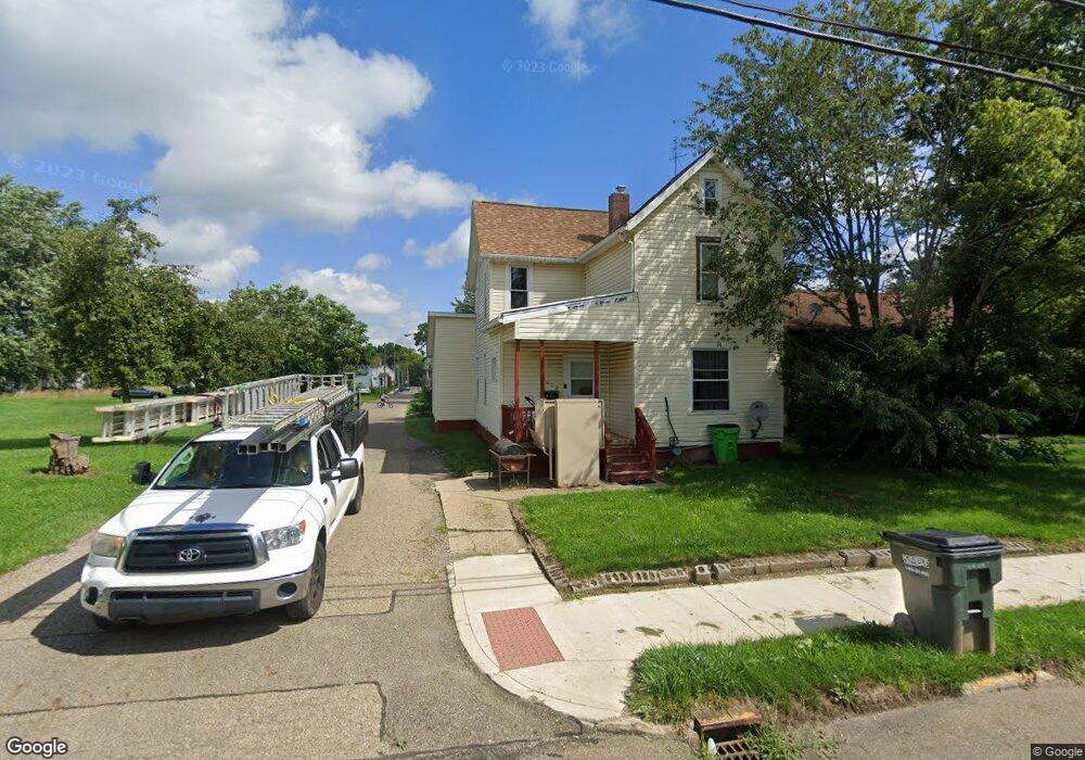
1020 E Patterson St Alliance, OH 44601
Estimated Value: $77,607 - $139,000
3
Beds
1
Bath
1,678
Sq Ft
$67/Sq Ft
Est. Value
About This Home
This home is located at 1020 E Patterson St, Alliance, OH 44601 and is currently estimated at $112,902, approximately $67 per square foot. 1020 E Patterson St is a home located in Stark County with nearby schools including Alliance Early Learning School, Alliance Intermediate School at Northside, and Alliance Middle School.
Ownership History
Date
Name
Owned For
Owner Type
Purchase Details
Closed on
Apr 25, 2002
Sold by
Smith Mildred A
Bought by
Smith Mildred A
Current Estimated Value
Purchase Details
Closed on
Jun 13, 2000
Sold by
Smith Mildred
Bought by
Nicholson Robert
Home Financials for this Owner
Home Financials are based on the most recent Mortgage that was taken out on this home.
Original Mortgage
$40,000
Interest Rate
8.56%
Mortgage Type
Purchase Money Mortgage
Create a Home Valuation Report for This Property
The Home Valuation Report is an in-depth analysis detailing your home's value as well as a comparison with similar homes in the area
Home Values in the Area
Average Home Value in this Area
Purchase History
| Date | Buyer | Sale Price | Title Company |
|---|---|---|---|
| Smith Mildred A | $46,529 | -- | |
| Nicholson Robert | -- | Gateway Title Service Agency |
Source: Public Records
Mortgage History
| Date | Status | Borrower | Loan Amount |
|---|---|---|---|
| Closed | Nicholson Robert | $40,000 |
Source: Public Records
Tax History
| Year | Tax Paid | Tax Assessment Tax Assessment Total Assessment is a certain percentage of the fair market value that is determined by local assessors to be the total taxable value of land and additions on the property. | Land | Improvement |
|---|---|---|---|---|
| 2025 | -- | $21,710 | $2,840 | $18,870 |
| 2024 | -- | $21,710 | $2,840 | $18,870 |
| 2023 | $343 | $8,540 | $560 | $7,980 |
| 2022 | $354 | $8,540 | $560 | $7,980 |
| 2021 | $355 | $8,540 | $560 | $7,980 |
| 2019 | $0 | $6,130 | $420 | $5,710 |
| 2018 | $0 | $6,130 | $420 | $5,710 |
| 2017 | $0 | $5,360 | $350 | $5,010 |
| 2016 | $0 | $5,360 | $350 | $5,010 |
| 2015 | -- | $5,360 | $350 | $5,010 |
| 2014 | -- | $3,680 | $530 | $3,150 |
| 2013 | -- | $3,680 | $530 | $3,150 |
Source: Public Records
Map
Nearby Homes
- 1025 Reed St
- 847 E Patterson St
- 1226 Noble St
- 361 E Main St
- 442 S Liberty Ave
- V/L S Freedom Ave
- 16190 River St NE
- 710 N Freedom Ave
- 955 E Summit St
- 62 E Market St
- 505 N Union Ave
- 15832 Waverly St NE
- 452 E Summit St
- 000 Lexington Rd
- 62 E High St
- 11344 Walnut Ave NE
- 726 S Arch Ave
- 22862 Norman Ave
- 935 S Morgan Ave
- 0 E Oxford St
- 1026 E Patterson St
- 958 E Patterson St
- 1040 E Patterson St
- 946 E Patterson St
- 1100 E Patterson St
- 942 E Patterson St
- 1005 Noble St
- 1039 E Patterson St
- 1001 Noble St
- 957 Noble St
- 1019 Noble St
- 951 Noble St
- 1108 E Patterson St
- 926 E Patterson St
- 1029 Noble St
- 937 Noble St
- 1039 Noble St
- 213 Franklin Ave
- 130 Wood Ave
- xx Kintz Woods Dr
Your Personal Tour Guide
Ask me questions while you tour the home.