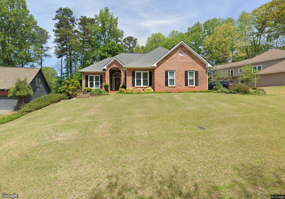
1020 Olde Canter Ct NW Marietta, GA 30064
Northwestern Marietta NeighborhoodEstimated Value: $597,761 - $624,000
3
Beds
3
Baths
2,344
Sq Ft
$263/Sq Ft
Est. Value
About This Home
This home is located at 1020 Olde Canter Ct NW, Marietta, GA 30064 and is currently estimated at $616,440, approximately $262 per square foot. 1020 Olde Canter Ct NW is a home located in Cobb County with nearby schools including A.L. Burruss Elementary School, Marietta Sixth Grade Academy, and Marietta Middle School.
Ownership History
Date
Name
Owned For
Owner Type
Purchase Details
Closed on
Feb 12, 2025
Sold by
Stancato Santino Patrick and Stancato Jenna Noelle
Bought by
Liescheidt Brent and Lugo Sasha Julie
Current Estimated Value
Home Financials for this Owner
Home Financials are based on the most recent Mortgage that was taken out on this home.
Original Mortgage
$554,400
Outstanding Balance
$550,639
Interest Rate
6.93%
Mortgage Type
New Conventional
Estimated Equity
$65,801
Purchase Details
Closed on
May 17, 2023
Sold by
Verity Family Revocable Trust
Bought by
Stancato Santino Patrick and Stancato Jenna Noelle
Home Financials for this Owner
Home Financials are based on the most recent Mortgage that was taken out on this home.
Original Mortgage
$494,000
Interest Rate
6.28%
Mortgage Type
New Conventional
Purchase Details
Closed on
Mar 31, 2016
Sold by
John
Bought by
Verity Fam Revoc Trust
Purchase Details
Closed on
Dec 10, 2014
Sold by
Moore Randall
Bought by
Verity John and Verity Margaret Harris
Home Financials for this Owner
Home Financials are based on the most recent Mortgage that was taken out on this home.
Original Mortgage
$165,900
Interest Rate
4.07%
Mortgage Type
New Conventional
Purchase Details
Closed on
May 23, 2003
Sold by
Craig Roland G
Bought by
Moore Randall and Moore Connie
Home Financials for this Owner
Home Financials are based on the most recent Mortgage that was taken out on this home.
Original Mortgage
$220,950
Interest Rate
5.43%
Mortgage Type
New Conventional
Purchase Details
Closed on
Jan 12, 1996
Sold by
Federal National Mortgage Association
Bought by
Neumeister Robert Betty
Purchase Details
Closed on
Oct 3, 1995
Sold by
National Mtg Inv Co
Bought by
Federal National Assn
Create a Home Valuation Report for This Property
The Home Valuation Report is an in-depth analysis detailing your home's value as well as a comparison with similar homes in the area
Home Values in the Area
Average Home Value in this Area
Purchase History
| Date | Buyer | Sale Price | Title Company |
|---|---|---|---|
| Liescheidt Brent | $616,000 | None Listed On Document | |
| Stancato Santino Patrick | $520,000 | None Listed On Document | |
| Verity Fam Revoc Trust | -- | -- | |
| Verity John | $265,900 | -- | |
| Moore Randall | $232,600 | -- | |
| Neumeister Robert Betty | $160,000 | -- | |
| Federal National Assn | -- | -- | |
| National Mtg Inv Co | $148,460 | -- |
Source: Public Records
Mortgage History
| Date | Status | Borrower | Loan Amount |
|---|---|---|---|
| Open | Liescheidt Brent | $554,400 | |
| Previous Owner | Stancato Santino Patrick | $494,000 | |
| Previous Owner | Verity John | $165,900 | |
| Previous Owner | Moore Randall | $220,950 | |
| Closed | Neumeister Robert Betty | $0 |
Source: Public Records
Tax History Compared to Growth
Tax History
| Year | Tax Paid | Tax Assessment Tax Assessment Total Assessment is a certain percentage of the fair market value that is determined by local assessors to be the total taxable value of land and additions on the property. | Land | Improvement |
|---|---|---|---|---|
| 2025 | $1,292 | $206,028 | $52,000 | $154,028 |
| 2024 | $1,292 | $206,028 | $52,000 | $154,028 |
| 2023 | $528 | $162,752 | $44,000 | $118,752 |
| 2022 | $681 | $139,100 | $24,000 | $115,100 |
| 2021 | $699 | $139,100 | $24,000 | $115,100 |
| 2020 | $697 | $125,820 | $24,000 | $101,820 |
| 2019 | $697 | $125,820 | $24,000 | $101,820 |
| 2018 | $696 | $115,800 | $24,000 | $91,800 |
| 2017 | $559 | $115,800 | $24,000 | $91,800 |
| 2016 | $559 | $100,112 | $24,000 | $76,112 |
| 2015 | $611 | $100,112 | $24,000 | $76,112 |
| 2014 | $628 | $90,448 | $0 | $0 |
Source: Public Records
Map
Nearby Homes
- 1032 Chippendale Trail SW
- 1077 New Haven Dr SW Unit 12A
- 945 Burnt Hickory Cir NW Unit 8
- 1156 Grand Oaks Glen NW
- 1141 Whitlock Ave NW
- 927 Burnt Hickory Cir NW Unit 10
- 805 Manning Way SW
- 818 Manning Way SW Unit 1
- 1099 Burnt Hickory Rd NW
- 290 Westland Way SW
- 1410 Dallas Cir SW
- 1211 Cliffpine Ct SW
- 560 Manning Rd SW
- 917 Wemberley Ln
- 1198 Seminary Dr SW
- 909 Wemberley Ln
- 984 Wemberley Ln
- 002 Wakehurst Way
- 201 Wakehurst Way
- 920 Wemberley Ln
- 1030 Olde Canter Ct SW
- 1010 Olde Canter Ct SW
- 1307 Whitlock Ridge Dr SW
- 1035 Olde Canter Ct SW Unit I
- 1045 Olde Canter Ct SW
- 1040 Olde Canter Ct SW
- 1025 Olde Canter Ct SW
- 1305 Whitlock Ridge Dr SW
- 1309 Whitlock Ridge Dr SW
- 1041 Chippendale Trail SW
- 1303 Whitlock Ridge Dr SW
- 1311 Whitlock Ridge Dr SW
- 1301 Whitlock Ridge Dr SW Unit 1
- 1047 Chippendale Trail SW
- 1047 Chippendale Trail NW
- 1015 Olde Canter Ct SW
- 1299 Whitlock Ridge Dr SW
- 1037 Chippendale Trail SW
- 1313 Whitlock Ridge Dr SW Unit 1
- 1005 Olde Canter Ct SW