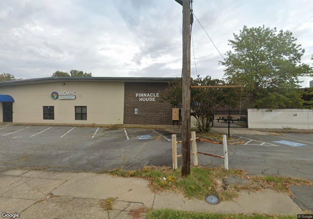
1020 W Daisy L Gatson Bates Dr Little Rock, AR 72202
Downtown Little Rock NeighborhoodEstimated Value: $1,568,374
--
Bed
--
Bath
11,528
Sq Ft
$136/Sq Ft
Est. Value
About This Home
This home is located at 1020 W Daisy L Gatson Bates Dr, Little Rock, AR 72202 and is currently estimated at $1,568,374, approximately $136 per square foot. 1020 W Daisy L Gatson Bates Dr is a home located in Pulaski County with nearby schools including M.L. King Elementary School, Dunbar Magnet Middle School, and Central High School.
Ownership History
Date
Name
Owned For
Owner Type
Purchase Details
Closed on
Jan 6, 2021
Sold by
Little Rock Cmnty Mental Health Ctr Inc
Bought by
Lakeland West Capital 38 Llc
Current Estimated Value
Purchase Details
Closed on
Jan 16, 2007
Sold by
Catherines House
Bought by
Little Rock Community Mental Health Cent
Home Financials for this Owner
Home Financials are based on the most recent Mortgage that was taken out on this home.
Original Mortgage
$768,000
Interest Rate
6.1%
Mortgage Type
Commercial
Create a Home Valuation Report for This Property
The Home Valuation Report is an in-depth analysis detailing your home's value as well as a comparison with similar homes in the area
Home Values in the Area
Average Home Value in this Area
Purchase History
| Date | Buyer | Sale Price | Title Company |
|---|---|---|---|
| Lakeland West Capital 38 Llc | $585,000 | None Available | |
| Little Rock Community Mental Health Cent | $955,000 | Lenders Title Company |
Source: Public Records
Mortgage History
| Date | Status | Borrower | Loan Amount |
|---|---|---|---|
| Previous Owner | Little Rock Community Mental Health Cent | $768,000 |
Source: Public Records
Tax History Compared to Growth
Tax History
| Year | Tax Paid | Tax Assessment Tax Assessment Total Assessment is a certain percentage of the fair market value that is determined by local assessors to be the total taxable value of land and additions on the property. | Land | Improvement |
|---|---|---|---|---|
| 2025 | $6,565 | $93,780 | $16,800 | $76,980 |
| 2024 | $6,565 | $93,780 | $16,800 | $76,980 |
| 2023 | $6,565 | $93,780 | $16,800 | $76,980 |
| 2022 | $6,565 | $93,780 | $16,800 | $76,980 |
| 2021 | $1,176 | $16,800 | $16,800 | $0 |
| 2020 | $1,176 | $16,800 | $16,800 | $0 |
| 2019 | $1,176 | $16,800 | $16,800 | $0 |
| 2018 | $1,176 | $16,800 | $16,800 | $0 |
| 2017 | $1,176 | $16,800 | $16,800 | $0 |
| 2016 | $2,465 | $35,220 | $10,800 | $24,420 |
| 2015 | $2,469 | $35,220 | $10,800 | $24,420 |
| 2014 | $2,469 | $35,220 | $10,800 | $24,420 |
Source: Public Records
Map
Nearby Homes
- 1015 W 15th St
- 1416 S Izard St
- 1114 W 12th St
- 1518 S Cross St
- Lot 219/3 S State St Unit 34L0201116800
- 1515 S Izard St
- 1608 S Cross St
- 1505 S State St
- 1504 S Arch St
- 1853 S Ringo St
- 1708 S Arch St
- 1504 Bishop St
- 1855 S Chester St
- 1850 S Ringo St
- 1520 Broadway St
- 1701 S Arch St
- 1867 S Ringo St
- 1870 S Izard St
- 1873 S Cross St
- 1417 Wolfe St
- 1019 W 13th St
- 1023 W 13th St
- E Daisy Bates
- 1418 S Chester St
- 1105 W 13th St
- 1109 W 13th St
- 1414 S Ringo St
- 1409 S Chester St
- 1112 W 13th St
- 1411 S Chester St
- 1415 S Chester St
- 1218 S Ringo St
- 1417 S Chester St
- 1421 S Chester St
- 1406 S Izard St
- 1204 S Ringo St
- 1408 S Izard St
- 1423 S Cross St
- 1017 W 15th St
- 1021 W 15th St