

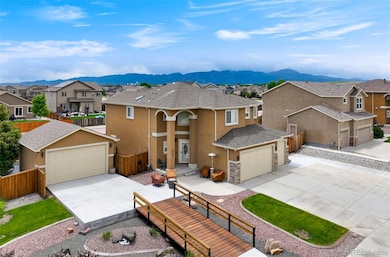

10202 Abrams Dr Colorado Springs, CO 80925
Widefield NeighborhoodEstimated payment $3,930/month
Highlights
- Primary Bedroom Suite
- Mountainous Lot
- Corner Lot
- Mountain View
- Wood Flooring
- High Ceiling
About This Home
One-of-a-Kind Home in Lorson Ranch | 5 Beds, 4 Baths, 6-Car Garage, Secured RV Parking & Peaceful Covered Patio! ***NEW ROOF AND GUTTERS HAVE BEEN INSTALLED!*** Step into a home that perfectly balances craftsmanship, functionality, and style—nestled in the sought-after Lorson Ranch community and built by renowned Windsor Ridge Homes. This 5-bedroom, 4-bathroom beauty is packed with premium upgrades and thoughtful touches throughout.
Enjoy the rare benefit of a 6-car garage, complete with secured RV parking and a beautifully designed bridge-style entrance that connects to the second garage—ideal for extra vehicles, storage, or hobby space with a flair of architectural charm.
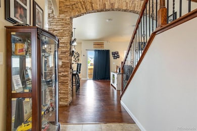
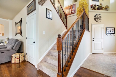
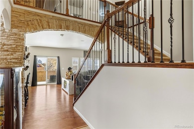
As you enter, you’ll immediately notice the custom stone accents on the interior archway and stone-wrapped breakfast bar, creating a warm and elevated ambiance. The formal living room features hardwood flooring and a cozy fireplace, while the gourmet kitchen showcases granite countertops, stainless steel appliances, a spacious counter bar, and hardwood floors that continue into the formal dining room—a perfect flow for entertaining.
The private primary suite is a relaxing retreat offering a walk-in closet and spa-like 5-piece bath with a garden tub and separate shower. Four additional bedrooms and three more bathrooms provide plenty of room for family, guests, or your ideal work-from-home setup.
Enjoy enhanced energy efficiency with the whole-house attic fan, keeping the home cool and comfortable year-round.
Outside, the professionally landscaped front yard offers stunning curb appeal, while the covered back patio is the perfect spot to enjoy quiet mornings or evening gatherings with friends and family under the Colorado sky.
This one-of-a-kind home truly has it all—premium upgrades, thoughtful design, and unbeatable functionality in one of the area's most desirable neighborhoods.
**When using our preferred lender, Shanon Schinkel with NFM, 1% credit toward buyer rate buy down.**
Listing Agent
The Cutting Edge Brokerage Email: Rhonda@covey.properties,719-580-0635 License #100082611 Listed on: 06/07/2025

Home Details
Home Type
- Single Family
Est. Annual Taxes
- $4,366
Year Built
- Built in 2014
Lot Details
- 0.28 Acre Lot
- Partially Fenced Property
- Landscaped
- Corner Lot
- Mountainous Lot
Parking
- 4 Car Attached Garage
- 2 Carport Spaces
Home Design
- Frame Construction
- Composition Roof
- Stucco
Interior Spaces
- 2-Story Property
- Sound System
- High Ceiling
- Skylights
- Gas Fireplace
- Smart Doorbell
- Family Room with Fireplace
- Wood Flooring
- Mountain Views
- Finished Basement
- 1 Bedroom in Basement
- Attic Fan
Kitchen
- Range
- Microwave
- Dishwasher
- Kitchen Island
- Granite Countertops
- Disposal
Bedrooms and Bathrooms
- 5 Bedrooms
- Primary Bedroom Suite
- Walk-In Closet
- Soaking Tub
Home Security
- Carbon Monoxide Detectors
- Fire and Smoke Detector
Outdoor Features
- Covered Patio or Porch
Schools
- Sunrise Elementary School
- Janitell Middle School
- Mesa Ridge High School
Utilities
- Forced Air Heating and Cooling System
- 220 Volts in Garage
- Natural Gas Connected
- Gas Water Heater
- High Speed Internet
Community Details
- No Home Owners Association
- Built by Windsor Ridge Homes
- The Meadows At Lorson Ranch Subdivision, Chesepeake Floorplan
Listing and Financial Details
- Exclusions: Seller Personal Property, Washer, Dryer
- Assessor Parcel Number 55143-19-001
Map
Home Values in the Area
Average Home Value in this Area
Tax History
| Year | Tax Paid | Tax Assessment Tax Assessment Total Assessment is a certain percentage of the fair market value that is determined by local assessors to be the total taxable value of land and additions on the property. | Land | Improvement |
|---|---|---|---|---|
| 2025 | $5,381 | $38,080 | -- | -- |
| 2024 | $4,321 | $39,420 | $6,040 | $33,380 |
| 2022 | $4,099 | $29,610 | $4,810 | $24,800 |
| 2021 | $3,860 | $27,550 | $4,950 | $22,600 |
| 2020 | $3,803 | $26,860 | $4,330 | $22,530 |
| 2019 | $3,791 | $26,860 | $4,330 | $22,530 |
| 2018 | $3,555 | $24,800 | $4,360 | $20,440 |
| 2017 | $3,629 | $24,800 | $4,360 | $20,440 |
| 2016 | $3,246 | $25,080 | $4,380 | $20,700 |
| 2015 | $3,419 | $25,080 | $4,380 | $20,700 |
| 2014 | $3,403 | $25,070 | $4,290 | $20,780 |
Property History
| Date | Event | Price | List to Sale | Price per Sq Ft |
|---|---|---|---|---|
| 07/28/2025 07/28/25 | Price Changed | $680,000 | -1.4% | $214 / Sq Ft |
| 06/07/2025 06/07/25 | For Sale | $690,000 | -- | $217 / Sq Ft |
Purchase History
| Date | Type | Sale Price | Title Company |
|---|---|---|---|
| Special Warranty Deed | $70,000 | Heritage Title | |
| Special Warranty Deed | $70,000 | Heritage Title |
Source: REcolorado®
MLS Number: 1854755
APN: 55143-19-001
Disclaimer: Certain information contained herein is derived from information provided by parties other than Homes.com. All information provided is deemed reliable, but is not guaranteed to be accurate and should be independently verified.
![]() The content relating to real estate for sale in this Web site comes in part from the Internet Data eXchange (“IDX”) program of METROLIST, INC., DBA RECOLORADO®. Real estate listings held by brokers other than Ten-X are marked with the IDX Logo. This information is being provided for the consumers’ personal, non-commercial use and may not be used for any other purpose. All information subject to change and should be independently verified.
The content relating to real estate for sale in this Web site comes in part from the Internet Data eXchange (“IDX”) program of METROLIST, INC., DBA RECOLORADO®. Real estate listings held by brokers other than Ten-X are marked with the IDX Logo. This information is being provided for the consumers’ personal, non-commercial use and may not be used for any other purpose. All information subject to change and should be independently verified.
This publication is designed to provide information with regard to the subject matter covered. It is displayed with the understanding that the publisher and authors are not engaged in rendering real estate, legal, accounting, tax, or other professional services and that the publisher and authors are not offering such advice in this publication. If real estate, legal, or other expert assistance is required, the services of a competent, professional person should be sought.
The information contained in this publication is subject to change without notice. METROLIST, INC., DBA RECOLORADO MAKES NO WARRANTY OF ANY KIND WITH REGARD TO THIS MATERIAL, INCLUDING, BUT NOT LIMITED TO, THE IMPLIED WARRANTIES OF MERCHANTABILITY AND FITNESS FOR A PARTICULAR PURPOSE. METROLIST, INC., DBA RECOLORADO SHALL NOT BE LIABLE FOR ERRORS CONTAINED HEREIN OR FOR ANY DAMAGES IN CONNECTION WITH THE FURNISHING, PERFORMANCE, OR USE OF THIS MATERIAL.
PUBLISHER’S NOTICE: All real estate advertised herein is subject to the Federal Fair Housing Act and the Colorado Fair Housing Act, which Acts make it illegal to make or publish any advertisement that indicates any preference, limitation, or discrimination based on race, color, religion, sex, handicap, familial status, or national origin.
METROLIST, INC., DBA RECOLORADO will not knowingly accept any advertising for real estate that is in violation of the law. All persons are hereby informed that all dwellings advertised are available on an equal opportunity basis.
© 2025 METROLIST, INC., DBA RECOLORADO® – All Rights Reserved. 6455 S. Yosemite St., Suite 500 Greenwood Village, CO 80111 USA
ALL RIGHTS RESERVED WORLDWIDE. No part of this publication may be reproduced, adapted, translated, stored in a retrieval system or transmitted in any form or by any means, electronic, mechanical, photocopying, recording, or otherwise, without the prior written permission of the publisher. The information contained herein including but not limited to all text, photographs, digital images, virtual tours, may be seeded and monitored for protection and tracking.
- 10208 Abrams Dr
- 10868 Deer Meadow Cir
- 10732 Deer Meadow Cir
- 6572 Justice Way
- 10250 Intrepid Way
- 6375 White Wolf Point
- 6225 Laurel Grass Range Trail
- 6562 Phantom Way
- 10394 Abrams Dr
- 10405 Abrams Dr
- 6431 Old Glory Dr
- 10604 Deer Meadow Cir
- 6672 Kearsarge Dr
- 6071 Old Glory Dr
- 6241 Old Glory Dr
- 6231 Old Glory Dr
- 10442 Abrams Dr
- 6868 Alsea Dr
- 10670 Abrams Dr
- 6705 Liberator Trail
- 6550 Alliance Loop
- 10756 Deer Meadow Cir
- 6605 Alliance Loop
- 10085 Thunderbolt Trail
- 10003 Seawolf Dr
- 10165 Castor Dr
- 6343 Wallowing Way
- 10032 Castor Dr
- 6673 Galpin Dr
- 6943 Akela Ln
- 6792 Galpin Dr
- 10512 Horton Dr
- 10471 Horton Dr
- 10785 Horton Dr
- 11125 Rockcastle Dr
- 6047 Mumford Dr
- 11207 House Finch Ln
- 11277 House Finch Ln
- 11257 House Finch Ln
- 11237 House Finch Ln