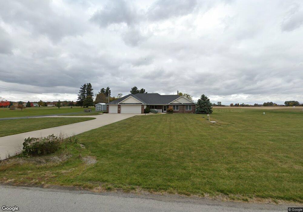
10203 Paulding Rd New Haven, IN 46774
Estimated Value: $333,000 - $499,268
3
Beds
2
Baths
2,743
Sq Ft
$154/Sq Ft
Est. Value
About This Home
This home is located at 10203 Paulding Rd, New Haven, IN 46774 and is currently estimated at $423,067, approximately $154 per square foot. 10203 Paulding Rd is a home located in Allen County with nearby schools including New Haven Primary School, New Haven Intermediate School, and New Haven High School.
Ownership History
Date
Name
Owned For
Owner Type
Purchase Details
Closed on
Nov 3, 2004
Sold by
Rorick Thomas F and Rorick Lillie D
Bought by
Roth Gregory and Roth Dolores
Current Estimated Value
Purchase Details
Closed on
Oct 22, 2004
Sold by
Rorick Farms Inc
Bought by
Rorick Thomas F and Rorick Lillie D
Create a Home Valuation Report for This Property
The Home Valuation Report is an in-depth analysis detailing your home's value as well as a comparison with similar homes in the area
Home Values in the Area
Average Home Value in this Area
Purchase History
| Date | Buyer | Sale Price | Title Company |
|---|---|---|---|
| Roth Gregory | -- | Century Title Services | |
| Rorick Thomas F | -- | Century Title Services | |
| Rorick Thomas F | -- | Century Title Services |
Source: Public Records
Tax History Compared to Growth
Tax History
| Year | Tax Paid | Tax Assessment Tax Assessment Total Assessment is a certain percentage of the fair market value that is determined by local assessors to be the total taxable value of land and additions on the property. | Land | Improvement |
|---|---|---|---|---|
| 2024 | $3,576 | $429,600 | $40,100 | $389,500 |
| 2022 | $3,271 | $354,500 | $40,100 | $314,400 |
| 2021 | $3,013 | $299,800 | $40,100 | $259,700 |
| 2020 | $2,487 | $265,000 | $40,100 | $224,900 |
| 2019 | $2,420 | $254,200 | $40,100 | $214,100 |
| 2018 | $2,573 | $252,700 | $40,100 | $212,600 |
| 2017 | $2,608 | $251,700 | $40,100 | $211,600 |
| 2016 | $2,570 | $247,900 | $40,100 | $207,800 |
| 2014 | $2,237 | $221,500 | $40,100 | $181,400 |
| 2013 | $2,477 | $239,000 | $40,100 | $198,900 |
Source: Public Records
Map
Nearby Homes
- Hardin Plan at Kennebec - Paired Villas
- Olsen Plan at Kennebec - Paired Villas
- Wabash Plan at Kennebec - Paired Villas
- Chatham Plan at Kennebec
- Stamford Plan at Kennebec
- Pine Plan at Kennebec
- Elder Plan at Kennebec
- Freeport Plan at Kennebec
- Fairton Plan at Kennebec
- Henley Plan at Kennebec
- 5135 Buffay Ct
- 5048 Beechmont Ln
- 5065 Buffay Ct
- 5040 Beechmont Ln
- 5057 Buffay Ct
- 5024 Beechmont Ln
- 5016 Beechmont Ln
- 5011 Beechmont Ln
- 5008 Beechmont Ln
- 4701 Heathermoor Ln
- 10125 Paulding Rd
- 5611 Green Rd
- 5717 Green Rd
- 10104 Paulding Rd
- 5724 Green Rd
- 10024 Paulding Rd
- 10416 Paulding Rd
- 9919 Paulding Rd
- 5430 Green Rd
- 5606 Green Rd
- 9817 Paulding Rd
- 5334 Green Rd
- 5414 Green Rd
- 10219 Ashby Trail Unit 36206674
- 10433 Paulding Rd
- 5235 Bing Pass Unit 36206668
- 5235 Bing Pass Unit 36206665
- 5235 Bing Pass Unit 36206666
- 5234 Green Rd
- 5134 Bing Pass