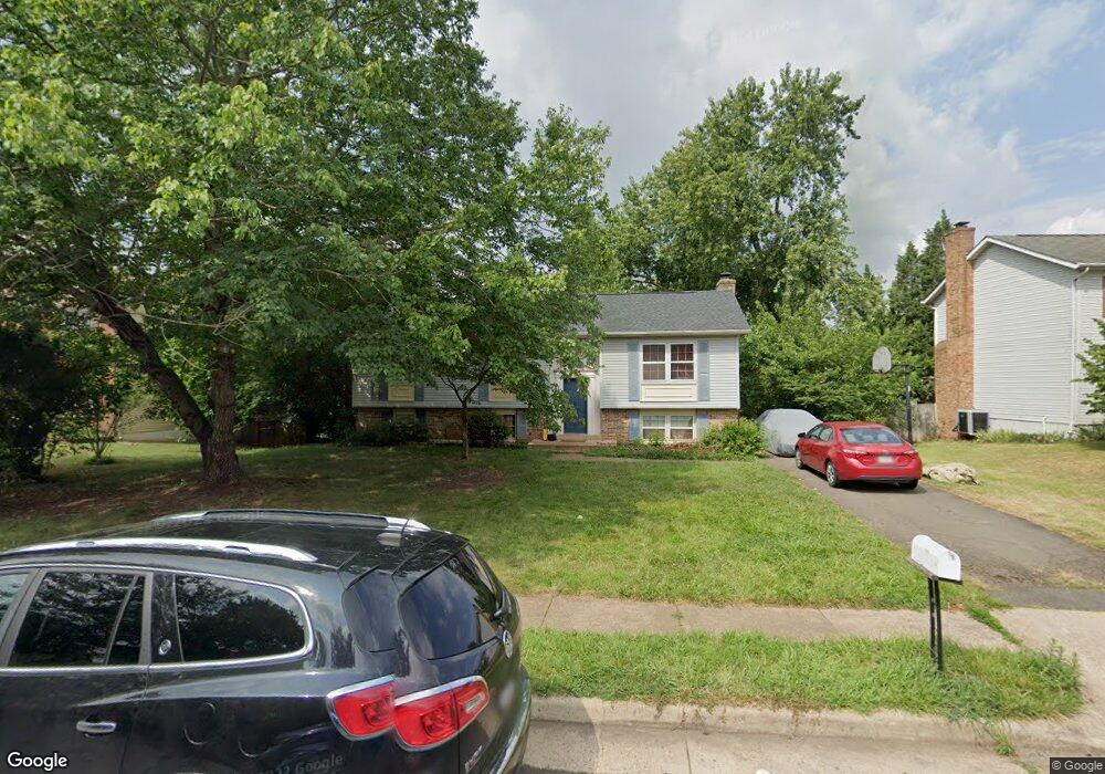
10206 Battlefield Dr Manassas, VA 20110
Old Town Manassas NeighborhoodEstimated Value: $485,915 - $562,000
3
Beds
2
Baths
1,098
Sq Ft
$468/Sq Ft
Est. Value
About This Home
This home is located at 10206 Battlefield Dr, Manassas, VA 20110 and is currently estimated at $513,979, approximately $468 per square foot. 10206 Battlefield Dr is a home located in Manassas City with nearby schools including George Carr Round Elementary School, Mayfield Intermediate School, and Grace E. Metz Middle School.
Ownership History
Date
Name
Owned For
Owner Type
Purchase Details
Closed on
Aug 24, 1998
Sold by
Paeno Joseph M and Paeno Barbara L
Bought by
Qureshi Mannan N and Qureshi Lubna
Current Estimated Value
Home Financials for this Owner
Home Financials are based on the most recent Mortgage that was taken out on this home.
Original Mortgage
$145,250
Outstanding Balance
$30,144
Interest Rate
6.86%
Mortgage Type
New Conventional
Estimated Equity
$483,835
Create a Home Valuation Report for This Property
The Home Valuation Report is an in-depth analysis detailing your home's value as well as a comparison with similar homes in the area
Home Values in the Area
Average Home Value in this Area
Purchase History
| Date | Buyer | Sale Price | Title Company |
|---|---|---|---|
| Qureshi Mannan N | $152,900 | -- |
Source: Public Records
Mortgage History
| Date | Status | Borrower | Loan Amount |
|---|---|---|---|
| Open | Qureshi Mannan N | $145,250 |
Source: Public Records
Tax History Compared to Growth
Tax History
| Year | Tax Paid | Tax Assessment Tax Assessment Total Assessment is a certain percentage of the fair market value that is determined by local assessors to be the total taxable value of land and additions on the property. | Land | Improvement |
|---|---|---|---|---|
| 2024 | $5,148 | $408,600 | $167,000 | $241,600 |
| 2023 | $4,954 | $393,200 | $162,000 | $231,200 |
| 2022 | $4,670 | $348,000 | $141,000 | $207,000 |
| 2021 | $4,456 | $311,800 | $125,500 | $186,300 |
| 2020 | $4,192 | $287,100 | $121,500 | $165,600 |
| 2019 | $4,108 | $277,600 | $118,000 | $159,600 |
| 2018 | $3,904 | $267,400 | $112,500 | $154,900 |
| 2017 | -- | $263,200 | $112,500 | $150,700 |
| 2016 | $3,693 | $263,200 | $0 | $0 |
| 2015 | -- | $254,600 | $112,500 | $142,100 |
| 2014 | -- | $0 | $0 | $0 |
Source: Public Records
Map
Nearby Homes
- 9541 Justin Ln
- 9444 Corey Dr
- 9521 Vinnia Ct
- 9348 Amaryllis Ave
- 9341 Amaryllis Ave
- 10102 Queens Way
- 10123 Erin Ct
- 10106 Queens Way
- 10114 Queens Way
- 10118 Queens Way
- 10130 Queens Way
- BALMORAL Plan at Kings Landing
- HIGHGROVE Plan at Kings Landing
- 10170 Queens Way
- 10166 Queens Way
- 9310 Saffron Hill Ct
- 10878 Peachwood Dr
- 9781 Mock Orange Ct
- 9317 Waterford Dr
- 9305 Gooseberry Dr
- 10204 Battlefield Dr
- 10208 Battlefield Dr
- 10211 Carmel Way
- 10210 Battlefield Dr
- 9631 Autumn Place
- 10202 Battlefield Dr
- 10213 Carmel Way
- 10207 Carmel Way
- 9628 Autumn Place
- 10207 Battlefield Dr
- 10212 Battlefield Dr
- 10215 Carmel Way
- 9629 Autumn Place
- 10205 Battlefield Dr
- 9629 Brendel Way
- 9626 Autumn Place
- 10208 Carmel Way
- 10214 Carmel Way
- 10214 Battlefield Dr
- 10216 Carmel Way