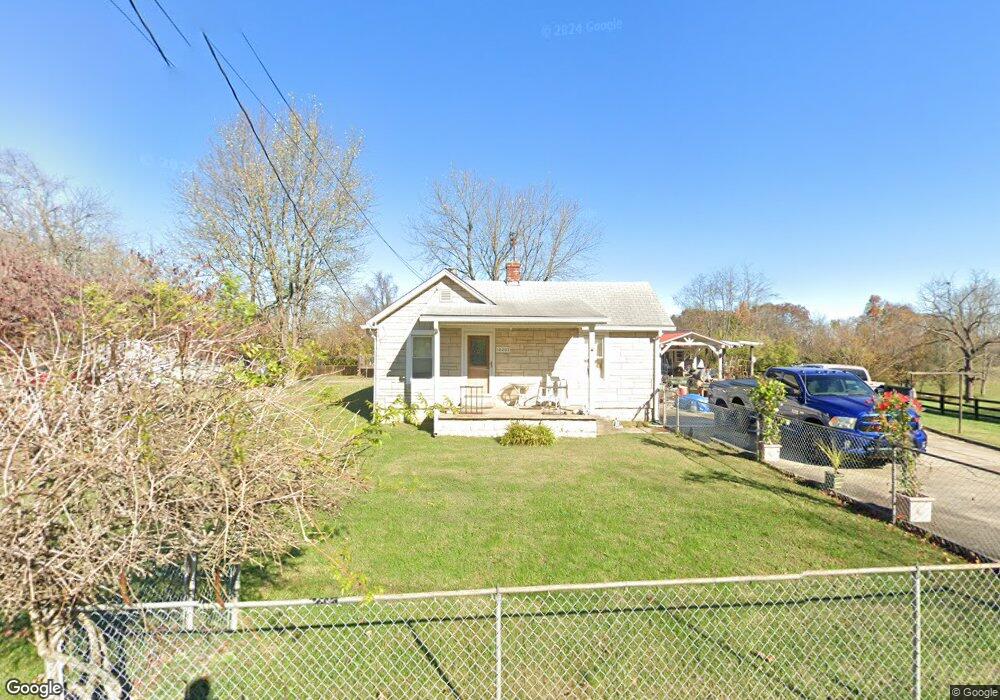
10207 Easum Rd Louisville, KY 40299
Estimated Value: $209,000 - $274,000
1
Bed
1
Bath
910
Sq Ft
$251/Sq Ft
Est. Value
About This Home
This home is located at 10207 Easum Rd, Louisville, KY 40299 and is currently estimated at $228,482, approximately $251 per square foot. 10207 Easum Rd is a home located in Jefferson County with nearby schools including Tully Elementary School, Cochrane Elementary School, and Jeffersontown Elementary School.
Ownership History
Date
Name
Owned For
Owner Type
Purchase Details
Closed on
Jun 2, 2011
Sold by
Stuart Cheri Lynn
Bought by
Mcintosh Neville Forrest
Current Estimated Value
Purchase Details
Closed on
Apr 30, 2007
Sold by
Shirley Bobby L and Shirley Barbara E
Bought by
Mcintosh Neville
Home Financials for this Owner
Home Financials are based on the most recent Mortgage that was taken out on this home.
Original Mortgage
$116,800
Interest Rate
6.1%
Mortgage Type
Purchase Money Mortgage
Create a Home Valuation Report for This Property
The Home Valuation Report is an in-depth analysis detailing your home's value as well as a comparison with similar homes in the area
Home Values in the Area
Average Home Value in this Area
Purchase History
| Date | Buyer | Sale Price | Title Company |
|---|---|---|---|
| Mcintosh Neville Forrest | -- | None Available | |
| Mcintosh Neville | $146,400 | Heritage Title |
Source: Public Records
Mortgage History
| Date | Status | Borrower | Loan Amount |
|---|---|---|---|
| Previous Owner | Mcintosh Neville | $116,800 |
Source: Public Records
Tax History Compared to Growth
Tax History
| Year | Tax Paid | Tax Assessment Tax Assessment Total Assessment is a certain percentage of the fair market value that is determined by local assessors to be the total taxable value of land and additions on the property. | Land | Improvement |
|---|---|---|---|---|
| 2024 | $1,932 | $170,210 | $62,400 | $107,810 |
| 2023 | $1,605 | $137,420 | $54,000 | $83,420 |
| 2022 | $1,583 | $137,420 | $54,000 | $83,420 |
| 2021 | $1,706 | $137,420 | $54,000 | $83,420 |
| 2020 | $1,475 | $127,510 | $53,980 | $73,530 |
| 2019 | $1,446 | $127,510 | $53,980 | $73,530 |
| 2018 | $1,429 | $127,510 | $53,980 | $73,530 |
| 2017 | $1,338 | $127,510 | $53,980 | $73,530 |
| 2013 | $1,464 | $146,400 | $36,400 | $110,000 |
Source: Public Records
Map
Nearby Homes
- 10206 Easum Rd
- 5501 Billtown Rd
- 10004 Chenoweth Vista Way Unit 10004
- 9923 Chenoweth Vista Way Unit 9923
- 11201 Arbor Wood Dr
- 11306 Arbor Wood Dr
- 11321 Jefferson Trace Blvd
- 5109 Billtown Rd
- 9911 Sprig Way
- 5206 Old Billtown Rd
- 5610 Cynthia Dr
- 9720 Mary Dell Ln
- 6716 Sycamore Bend Trace
- 5627 Wooded Lake Dr
- 10011 Fern Creek Rd
- 5210 Cynthia Dr
- 5502 Sprigwood Ln
- 11001 Walbridge Dr Ct
- 6612 Rockview Way
- 6705 Bluffview Cir
- 10205 Easum Rd
- 10203 Easum Rd
- 10204 Easum Rd
- 10300 Easum Rd
- 10200 Easum Rd
- 5603 Billtown Rd
- 5605 Billtown Rd
- 10304 Easum Rd
- 10305 Easum Rd
- 10201 Easum Rd
- 5607 Billtown Rd
- 5609 Billtown Rd
- 10306 Easum Rd
- 5611 Billtown Rd
- 5511 Billtown Rd
- 10308 Easum Rd
- 5507 Billtown Rd
- 5613 Billtown Rd
- 5600 Billtown Rd
- 10311 Easum Rd