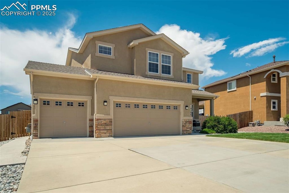
10208 Abrams Dr Colorado Springs, CO 80925
Widefield NeighborhoodEstimated payment $2,962/month
Highlights
- Mountain View
- Walk-In Pantry
- Property is near schools
- Wood Flooring
- 3 Car Attached Garage
- Forced Air Heating and Cooling System
About This Home
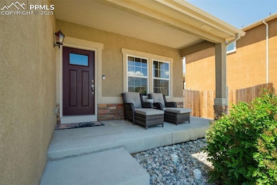
A Home That Captures Your Heart From the moment you arrive, you’ll know this isn’t just another house—it’s the one. With its striking curb appeal, light-filled interiors, and thoughtful design, this home invites you to live the lifestyle you’ve been dreaming of.
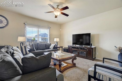
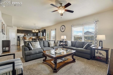
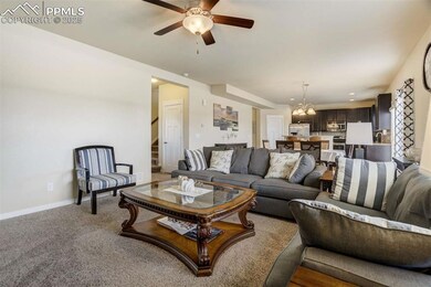
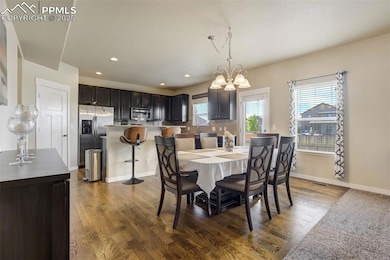
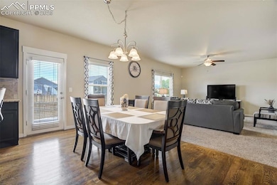
Step inside and be swept away by soaring ceilings, wide-open spaces, and sunlight pouring through picture windows. The gourmet kitchen is more than a place to cook—it’s a gathering space where conversations flow, laughter lingers, and every meal feels special. With stainless steel appliances, sleek counters, and seamless flow to the dining and living areas, entertaining has never been easier.
Your primary suite is a true retreat—wake up refreshed, sip coffee while gazing out your windows, and unwind each evening in your spa-inspired bath. Upstairs, flexible spaces give you freedom—a cozy loft for movie nights, a quiet home office, or the perfect playroom. Every corner of this home was designed for comfort, connection, and joy. But the magic doesn’t stop inside. Step out back and you’ll find your personal oasis—whether it’s summer BBQs, fireside evenings under the stars, or peaceful mornings with coffee in hand, this backyard was made for memories.
Luxury Lifestyle Highlights Dramatic open floor plan with abundant natural light Chef’s kitchen that brings everyone togethe
Spa-inspired primary suite for true relaxation Flexible loft for work, play, or escape Private backyard retreat made for entertaining Oversized garage with room for all your toys This isn’t just where you’ll live—it’s where you’ll love. Experience the blend of elegance, comfort, and connection
Home Details
Home Type
- Single Family
Est. Annual Taxes
- $4,702
Year Built
- Built in 2013
Lot Details
- 8,782 Sq Ft Lot
- Back Yard Fenced
Parking
- 3 Car Attached Garage
- Driveway
Home Design
- Shingle Roof
- Stucco
Interior Spaces
- 3,367 Sq Ft Home
- 2-Story Property
- Mountain Views
- Basement Fills Entire Space Under The House
- Laundry on upper level
Kitchen
- Walk-In Pantry
- Self-Cleaning Oven
- Plumbed For Gas In Kitchen
- Microwave
- Dishwasher
- Disposal
Flooring
- Wood
- Carpet
Bedrooms and Bathrooms
- 4 Bedrooms
Location
- Property is near schools
Utilities
- Forced Air Heating and Cooling System
- 220 Volts
- 220 Volts in Kitchen
Community Details
- Built by Aspen View Homes
- Mailibu
Map
Home Values in the Area
Average Home Value in this Area
Tax History
| Year | Tax Paid | Tax Assessment Tax Assessment Total Assessment is a certain percentage of the fair market value that is determined by local assessors to be the total taxable value of land and additions on the property. | Land | Improvement |
|---|---|---|---|---|
| 2025 | $4,702 | $33,750 | -- | -- |
| 2024 | $4,661 | $34,940 | $6,040 | $28,900 |
| 2022 | $3,437 | $24,830 | $4,810 | $20,020 |
| 2021 | $3,580 | $25,550 | $4,950 | $20,600 |
| 2020 | $3,527 | $24,910 | $4,330 | $20,580 |
| 2019 | $3,516 | $24,910 | $4,330 | $20,580 |
| 2018 | $3,034 | $21,170 | $4,360 | $16,810 |
| 2017 | $3,098 | $21,170 | $4,360 | $16,810 |
| 2016 | $2,674 | $20,660 | $4,380 | $16,280 |
| 2015 | $2,817 | $20,660 | $4,380 | $16,280 |
| 2014 | $2,755 | $20,300 | $4,290 | $16,010 |
Property History
| Date | Event | Price | List to Sale | Price per Sq Ft |
|---|---|---|---|---|
| 12/07/2025 12/07/25 | Pending | -- | -- | -- |
| 11/20/2025 11/20/25 | Price Changed | $490,000 | -3.0% | $146 / Sq Ft |
| 11/06/2025 11/06/25 | Price Changed | $505,000 | -1.9% | $150 / Sq Ft |
| 09/02/2025 09/02/25 | Price Changed | $515,000 | -1.0% | $153 / Sq Ft |
| 07/02/2025 07/02/25 | Price Changed | $520,000 | -1.9% | $154 / Sq Ft |
| 06/04/2025 06/04/25 | For Sale | $530,000 | -- | $157 / Sq Ft |
Purchase History
| Date | Type | Sale Price | Title Company |
|---|---|---|---|
| Warranty Deed | $285,275 | Unified Title Company | |
| Quit Claim Deed | -- | None Available |
Mortgage History
| Date | Status | Loan Amount | Loan Type |
|---|---|---|---|
| Open | $285,275 | VA |
Source: Pikes Peak REALTOR® Services
MLS Number: 4040808
APN: 55143-19-002
Disclaimer: Certain information contained herein is derived from information provided by parties other than Homes.com. All information provided is deemed reliable, but is not guaranteed to be accurate and should be independently verified.
![]() IDX information is provided exclusively for personal, non-commercial use, and may not be used for any purpose other than to identify prospective properties consumers may be interested in purchasing. Information is deemed reliable but not guaranteed.
IDX information is provided exclusively for personal, non-commercial use, and may not be used for any purpose other than to identify prospective properties consumers may be interested in purchasing. Information is deemed reliable but not guaranteed.
- 10202 Abrams Dr
- 10868 Deer Meadow Cir
- 10250 Intrepid Way
- 10732 Deer Meadow Cir
- 6572 Justice Way
- 6375 White Wolf Point
- 6672 Kearsarge Dr
- 6431 Old Glory Dr
- 10394 Abrams Dr
- 6868 Alsea Dr
- 6705 Liberator Trail
- 10604 Deer Meadow Cir
- 6733 Liberator Trail
- 6241 Old Glory Dr
- 6231 Old Glory Dr
- 6071 Old Glory Dr
- 10670 Abrams Dr
- 10442 Abrams Dr
- 6338 Bearcat Loop
- 10568 Kalama Dr
