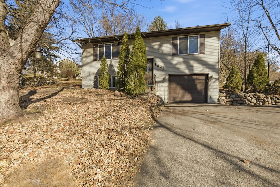
1021 5th St S Sauk Rapids, MN 56379
Estimated payment $1,478/month
Highlights
- Popular Property
- No HOA
- 1 Car Attached Garage
- Deck
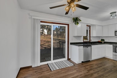
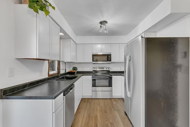
- The kitchen features windows
- Combination Kitchen and Dining Room
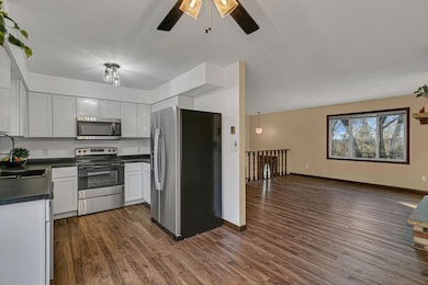
About This Home
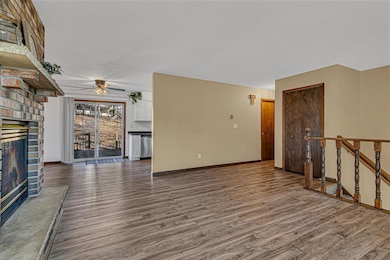
Turnkey split level with updates throughout. Home features a completely renovated kitchen including stainless steel appliances, as well as new flooring, light fixtures and paint throughout. Each room is bright, welcoming and perfectly prepared for your personal style. Additional features include oversized one-stall, finished and heated garage, ground level deck, storage shed and wooded lot.
Home Details
Home Type
- Single Family
Est. Annual Taxes
- $2,554
Year Built
- Built in 1977
Lot Details
- 0.29 Acre Lot
- Lot Dimensions are 104x132x107x108
Parking
- 1 Car Attached Garage
- Tuck Under Garage
Home Design
- Bi-Level Home
- Vinyl Siding
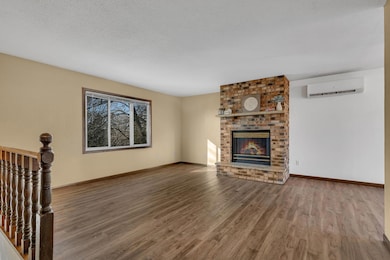
Interior Spaces
- Gas Fireplace
- Living Room with Fireplace
- Combination Kitchen and Dining Room
- Finished Basement
- Partial Basement
Kitchen
- Range
- Microwave
- Dishwasher
- The kitchen features windows
Bedrooms and Bathrooms
- 4 Bedrooms
Outdoor Features
- Deck
Utilities
- Mini Split Air Conditioners
- Heat Pump System
- Radiant Heating System
Community Details
- No Home Owners Association
- Sky View Terrace Subdivision
Listing and Financial Details
- Assessor Parcel Number 190171500
Map
Home Values in the Area
Average Home Value in this Area
Tax History
| Year | Tax Paid | Tax Assessment Tax Assessment Total Assessment is a certain percentage of the fair market value that is determined by local assessors to be the total taxable value of land and additions on the property. | Land | Improvement |
|---|---|---|---|---|
| 2025 | $2,564 | $207,800 | $32,600 | $175,200 |
| 2024 | $2,402 | $198,000 | $32,600 | $165,400 |
| 2023 | $2,334 | $196,500 | $32,600 | $163,900 |
| 2022 | $2,250 | $173,300 | $29,600 | $143,700 |
| 2021 | $2,084 | $150,900 | $29,600 | $121,300 |
| 2018 | $1,796 | $124,500 | $28,500 | $96,000 |
| 2017 | $1,796 | $114,200 | $28,500 | $85,700 |
| 2016 | $2,258 | $107,300 | $28,500 | $78,800 |
| 2015 | $1,806 | $101,000 | $28,500 | $72,500 |
| 2014 | -- | $97,400 | $28,500 | $68,900 |
| 2013 | -- | $69,900 | $20,266 | $49,634 |
Property History
| Date | Event | Price | List to Sale | Price per Sq Ft |
|---|---|---|---|---|
| 11/17/2025 11/17/25 | For Sale | $240,000 | -- | $159 / Sq Ft |
Purchase History
| Date | Type | Sale Price | Title Company |
|---|---|---|---|
| Interfamily Deed Transfer | -- | None Available | |
| Warranty Deed | $127,000 | None Available | |
| Interfamily Deed Transfer | $13,800 | -- | |
| Warranty Deed | $133,000 | -- |
Mortgage History
| Date | Status | Loan Amount | Loan Type |
|---|---|---|---|
| Open | $93,750 | New Conventional | |
| Previous Owner | $138,000 | New Conventional |
Source: NorthstarMLS
MLS Number: 6817911
APN: 19.01715.00
Disclaimer: Certain information contained herein is derived from information provided by parties other than Homes.com. All information provided is deemed reliable, but is not guaranteed to be accurate and should be independently verified.
![]() Based on information submitted to the MLS GRID. All data is obtained from various sources and may not have been verified by broker or MLS GRID. Supplied Open House Information is subject to change without notice. All information should be independently reviewed and verified for accuracy. Properties may or may not be listed by the office/agent presenting the information. Some IDX listings have been excluded from this website.
Based on information submitted to the MLS GRID. All data is obtained from various sources and may not have been verified by broker or MLS GRID. Supplied Open House Information is subject to change without notice. All information should be independently reviewed and verified for accuracy. Properties may or may not be listed by the office/agent presenting the information. Some IDX listings have been excluded from this website.
The Digital Millennium Copyright Act of 1998, 17 U.S.C. § 512 (the “DMCA”) provides recourse for copyright owners who believe that material appearing on the Internet infringes their rights under U.S. copyright law. If you believe in good faith that any content or material made available in connection with our website or services infringes your copyright, you (or your agent) may send us a notice requesting that the content or material be removed, or access to it blocked.
Notices must be sent in writing by email to DMCAnotice@MLSGrid.com.
The DMCA requires that your notice of alleged copyright infringement include the following information:
(1) description of the copyrighted work that is the subject of claimed infringement;
(2) description of the alleged infringing content and information sufficient to permit us to locate the content;
(3) contact information for you, including your address, telephone number and email address;
(4) a statement by you that you have a good faith belief that the content in the manner complained of is not authorized by the copyright owner, or its agent, or by the operation of any law;
(5) a statement by you, signed under penalty of perjury, that the information in the notification is accurate and that you have the authority to enforce the copyrights that are claimed to be infringed; and
(6) a physical or electronic signature of the copyright owner or a person authorized to act on the copyright owner’s behalf. Failure to include all of the above information may result in the delay of the processing of your complaint.
- 1 Skyview Dr
- 1804 8th Ave S
- 1803 8th Ave S
- 608 Summit Ave S
- 1000 10th Ave NE
- 112 Summit Ave S
- 1294 Stone Ridge Rd
- 920 Oakcrest Dr
- 1409 3rd Ave S
- 1011 Water Ave S
- 1424 Hillside Ct
- 1408 10th St NE
- 430 5th Ave NE
- 525 4th Ave NE
- 116 Columbia Ave NE
- 117 Columbia Ave NE
- 880 Golden Spike Rd NE
- xxx Lot 3
- 970 Golden Spike Rd NE
- 216 8th Ave N
- 1155 10th Ave NE
- 1251 10th Ave NE
- 304 4th St S Unit 102
- 1277 15th St NE
- 107 3rd Ave S
- 107 N Benton Dr
- 1244 E Saint Germain St
- 1220 E Saint Germain St
- 321 2nd Ave NE
- 1570 E St Germain St
- 45 14th Ave NE
- 230 2nd St NE
- 1001 Summit Ave N
- 1200 E Division St
- 1536 Northway Dr Unit 208
- 1536 Northway Dr Unit 211
- 1536 Northway Dr Unit 213
- 1451 2nd St SE
- 101 Riverside Dr SE
- 1225 14th St N
