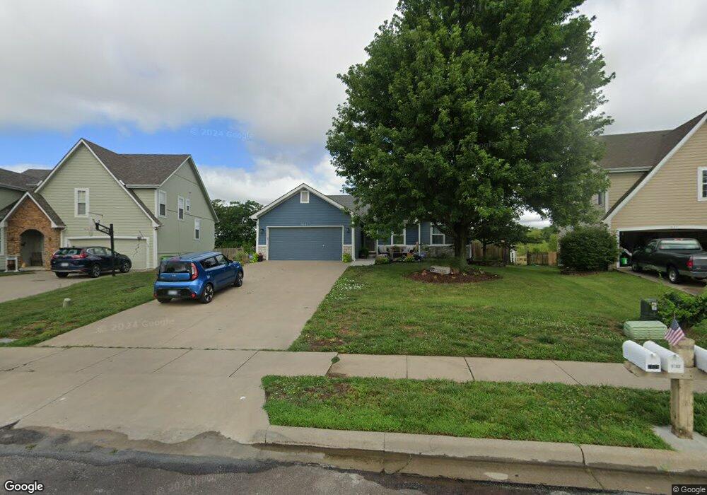
1021 Firetree Ave Baldwin City, KS 66006
Estimated Value: $332,603 - $363,000
3
Beds
2
Baths
1,608
Sq Ft
$216/Sq Ft
Est. Value
About This Home
This home is located at 1021 Firetree Ave, Baldwin City, KS 66006 and is currently estimated at $347,151, approximately $215 per square foot. 1021 Firetree Ave is a home located in Douglas County with nearby schools including Baldwin Elementary Primary Center, Baldwin Elementary Intermediate Center, and Baldwin Junior High School.
Ownership History
Date
Name
Owned For
Owner Type
Purchase Details
Closed on
Oct 3, 2001
Sold by
Kesinger Kent L and Kesinger Mary Jane
Bought by
Currie Bench A
Current Estimated Value
Home Financials for this Owner
Home Financials are based on the most recent Mortgage that was taken out on this home.
Original Mortgage
$20,800
Outstanding Balance
$8,136
Interest Rate
6.88%
Estimated Equity
$339,015
Create a Home Valuation Report for This Property
The Home Valuation Report is an in-depth analysis detailing your home's value as well as a comparison with similar homes in the area
Home Values in the Area
Average Home Value in this Area
Purchase History
| Date | Buyer | Sale Price | Title Company |
|---|---|---|---|
| Currie Bench A | -- | Executive Title Inc |
Source: Public Records
Mortgage History
| Date | Status | Borrower | Loan Amount |
|---|---|---|---|
| Open | Currie Bench A | $20,800 |
Source: Public Records
Tax History
| Year | Tax Paid | Tax Assessment Tax Assessment Total Assessment is a certain percentage of the fair market value that is determined by local assessors to be the total taxable value of land and additions on the property. | Land | Improvement |
|---|---|---|---|---|
| 2025 | $5,398 | $39,100 | $5,865 | $33,235 |
| 2024 | $5,335 | $37,973 | $4,945 | $33,028 |
| 2023 | $4,960 | $33,914 | $4,945 | $28,969 |
| 2022 | $4,577 | $30,421 | $4,945 | $25,476 |
| 2021 | $3,985 | $26,001 | $3,738 | $22,263 |
| 2020 | $3,752 | $24,300 | $3,220 | $21,080 |
| 2019 | $3,603 | $23,345 | $2,990 | $20,355 |
| 2018 | $3,595 | $22,908 | $2,760 | $20,148 |
| 2017 | $3,488 | $21,770 | $2,760 | $19,010 |
| 2016 | $3,521 | $22,368 | $2,760 | $19,608 |
| 2015 | $3,219 | $20,712 | $2,760 | $17,952 |
| 2014 | $3,123 | $20,735 | $2,760 | $17,975 |
Source: Public Records
Map
Nearby Homes
- 1013 Bluestem Dr
- Lot 5 Block 3 Bluestem Dr
- Lot 3 Block 2 Bluestem Dr
- Lot 6 Block 2 Bluestem Dr
- Lot 7 Block 2 Bluestem Dr
- Lot 12 Block 2 Bluestem Dr
- 1108 Bluestem Dr
- 605 Parkside Ct
- 10± Acres E 1700 Rd
- 118 7th St
- 1105 Chapel St
- 915 Eagle Ridge Dr
- 917 Eagle Ridge Dr
- 1112 Grove St
- 819 7th St
- 441 E 1700 Rd
- 80 E 1600 Rd
- 1587 N 450th Rd
- 214 Hillside Dr
- 218 Hillside Dr
- 1019 Firetree Ave
- 1023 Firetree Ave
- 1017 Firetree Ave
- 1027 Firetree Ave
- 1003 Lisa Ct
- 1022 Firetree Ave
- 1018 Firetree Ave
- 1026 Firetree Ave
- 1014 Firetree Ave
- 1013 Firetree Ave
- 1005 Lisa Ct
- 1030 Firetree Ave
- 1010 Firetree Ave
- 926 Jasara Cir
- 1033 Firetree Ave
- 927 Jasara Cir
- 1004 Lisa Ct
- 1009 Firetree Ave
- 1002 Lisa Ct
- 1034 Firetree Ave
Your Personal Tour Guide
Ask me questions while you tour the home.