
Seller's Agent in 2025
Rebecca Strother
Duckworth Properties
(912) 223-1946
95 in this area
346 Total Sales
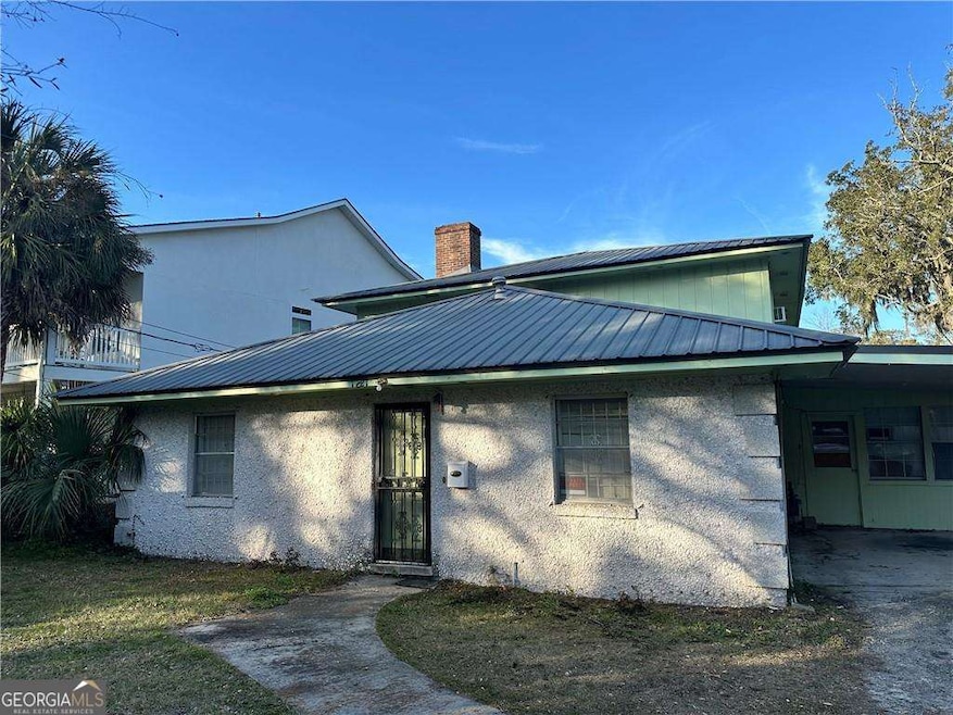
Incredible Renovation Opportunity on St. Simons Island! Unlock the full potential of this diamond in the rough! Located just moments from the pristine beaches, vibrant shopping, and delicious dining of St. Simons Island, this is the perfect project for investors or those looking for a vacation home with serious upside. The downstairs offers 4 bedrooms and 3 bathrooms, while the upstairs has the option to be a lockout with its own entrance in the rear features 3 bedrooms and 1 bathroom. Previous owner lived downstairs and rented out the upstairs. (lockout with a separate entrance) With a tabby exterior, a durable metal roof, and a spacious backyard, this property is ready for the right vision to bring it back to life. Whether you're looking for a profitable rental, a second home, or a project with long-term value, this property offers endless possibilities in one of Georgia's most desirable locations. Don't miss out on the chance to transform this gem into a high-demand rental or resale property. The potential for return is undeniable! Seize this opportunity today before it's gone!
Last Agent to Sell the Property
Duckworth Properties License #360510 Listed on: 07/15/2025
| Date | Type | Sale Price | Title Company |
|---|---|---|---|
| Warranty Deed | $655,000 | -- | |
| Warranty Deed | -- | -- | |
| Warranty Deed | -- | -- |
| Date | Status | Loan Amount | Loan Type |
|---|---|---|---|
| Previous Owner | $502,500 | FHA |
| Date | Event | Price | List to Sale | Price per Sq Ft |
|---|---|---|---|---|
| 09/19/2025 09/19/25 | Sold | $655,000 | -12.7% | $201 / Sq Ft |
| 09/11/2025 09/11/25 | Pending | -- | -- | -- |
| 07/15/2025 07/15/25 | For Sale | $750,000 | -- | $230 / Sq Ft |
| Year | Tax Paid | Tax Assessment Tax Assessment Total Assessment is a certain percentage of the fair market value that is determined by local assessors to be the total taxable value of land and additions on the property. | Land | Improvement |
|---|---|---|---|---|
| 2025 | $5,088 | $202,880 | $77,400 | $125,480 |
| 2024 | $5,088 | $202,880 | $77,400 | $125,480 |
| 2023 | $161 | $150,080 | $77,400 | $72,680 |
| 2022 | $228 | $142,800 | $77,400 | $65,400 |
| 2021 | $231 | $109,520 | $45,000 | $64,520 |
| 2020 | $234 | $109,520 | $45,000 | $64,520 |
| 2019 | $234 | $99,360 | $39,600 | $59,760 |
| 2018 | $234 | $99,360 | $39,600 | $59,760 |
| 2017 | $234 | $80,240 | $39,600 | $40,640 |
| 2016 | $211 | $80,240 | $39,600 | $40,640 |
| 2015 | $211 | $80,240 | $39,600 | $40,640 |
| 2014 | $211 | $80,240 | $39,600 | $40,640 |
Seller's Agent in 2025
Rebecca Strother
Duckworth Properties
(912) 223-1946
95 in this area
346 Total Sales
W
Buyer's Agent in 2025
Will Duckworth
Duckworth Properties
(912) 217-9076
57 in this area
434 Total Sales
Source: Georgia MLS
MLS Number: 10580442
APN: 04-03587
Disclaimer: Certain information contained herein is derived from information provided by parties other than Homes.com. All information provided is deemed reliable, but is not guaranteed to be accurate and should be independently verified.
![]() The data relating to real estate for sale on this web site comes in part from the Broker Reciprocity Program of Georgia MLS. Real estate listings held by brokerage firms other than Redfin are marked with the Broker Reciprocity logo and detailed information about them includes the name of the listing brokers. Information deemed reliable but not guaranteed. Copyright 2025 Georgia MLS. All rights reserved.
The data relating to real estate for sale on this web site comes in part from the Broker Reciprocity Program of Georgia MLS. Real estate listings held by brokerage firms other than Redfin are marked with the Broker Reciprocity logo and detailed information about them includes the name of the listing brokers. Information deemed reliable but not guaranteed. Copyright 2025 Georgia MLS. All rights reserved.