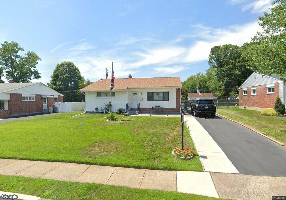
1021 Platt Ave Folsom, PA 19033
Estimated Value: $296,000 - $320,000
2
Beds
1
Bath
1,113
Sq Ft
$282/Sq Ft
Est. Value
About This Home
This home is located at 1021 Platt Ave, Folsom, PA 19033 and is currently estimated at $313,589, approximately $281 per square foot. 1021 Platt Ave is a home located in Delaware County with nearby schools including Edgewood Elementary School, Ridley Middle School, and Ridley High School.
Ownership History
Date
Name
Owned For
Owner Type
Purchase Details
Closed on
Jun 28, 1996
Sold by
Brown Margaret Loucretia and Eckman Thomas H
Bought by
Griffis Lee Mitchell
Current Estimated Value
Home Financials for this Owner
Home Financials are based on the most recent Mortgage that was taken out on this home.
Original Mortgage
$44,000
Outstanding Balance
$3,108
Interest Rate
7.98%
Estimated Equity
$310,481
Create a Home Valuation Report for This Property
The Home Valuation Report is an in-depth analysis detailing your home's value as well as a comparison with similar homes in the area
Home Values in the Area
Average Home Value in this Area
Purchase History
| Date | Buyer | Sale Price | Title Company |
|---|---|---|---|
| Griffis Lee Mitchell | $94,000 | -- |
Source: Public Records
Mortgage History
| Date | Status | Borrower | Loan Amount |
|---|---|---|---|
| Open | Griffis Lee Mitchell | $44,000 |
Source: Public Records
Tax History Compared to Growth
Tax History
| Year | Tax Paid | Tax Assessment Tax Assessment Total Assessment is a certain percentage of the fair market value that is determined by local assessors to be the total taxable value of land and additions on the property. | Land | Improvement |
|---|---|---|---|---|
| 2025 | $5,710 | $164,450 | $73,900 | $90,550 |
| 2024 | $5,710 | $164,450 | $73,900 | $90,550 |
| 2023 | $5,462 | $164,450 | $73,900 | $90,550 |
| 2022 | $5,286 | $164,450 | $73,900 | $90,550 |
| 2021 | $8,183 | $164,450 | $73,900 | $90,550 |
| 2020 | $5,473 | $96,890 | $36,730 | $60,160 |
| 2019 | $5,373 | $96,890 | $36,730 | $60,160 |
| 2018 | $5,306 | $96,890 | $0 | $0 |
| 2017 | $5,306 | $96,890 | $0 | $0 |
| 2016 | $532 | $96,890 | $0 | $0 |
| 2015 | $532 | $96,890 | $0 | $0 |
| 2014 | $532 | $96,890 | $0 | $0 |
Source: Public Records
Map
Nearby Homes
- 1306 Swarthmore Ave
- 924 Edgewood Ave
- 1152 Muhlenberg Ave
- 115 President Ave
- 1238 University Ave
- 1237 University Ave
- 354 S Swarthmore Ave Unit B3
- 537 Folsom Ave
- 226 W Sylvan Ave
- 516 Edgewood Ave
- 505 Fernwood Ave
- 511 Clark Ave
- 4 Linden Ave
- 20 Yale Ave
- 1828 5th Ave
- 345 Vassar Ave
- 313 Dickinson Ave
- 412 Gorsuch St
- 120 Bridge St
- 0 Gorsuch St
- 1015 Platt Ave
- 1027 Platt Ave
- 1200 Redwood Ave
- 1009 Platt Ave
- 1020 Platt Ave
- 1033 Platt Ave
- 1026 Platt Ave
- 1014 Platt Ave
- 1203 Redwood Ave
- 1206 Redwood Ave
- 1032 Platt Ave
- 1003 Platt Ave
- 1039 Platt Ave
- 1205 Redwood Ave
- 1021 11th Ave
- 1200 Sylvania Ave
- 1027 11th Ave
- 1015 11th Ave
- 1038 Platt Ave
- 1002 Platt Ave