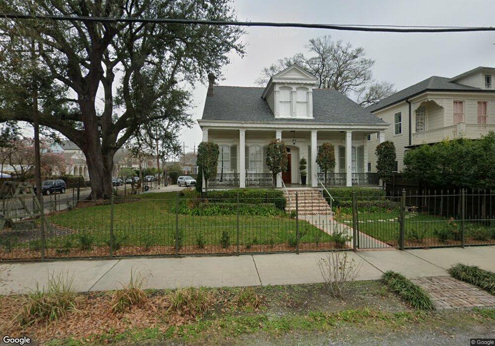
1021 Robert St New Orleans, LA 70115
Uptown NeighborhoodEstimated Value: $421,194 - $449,000
2
Beds
2
Baths
1,414
Sq Ft
$304/Sq Ft
Est. Value
About This Home
This home is located at 1021 Robert St, New Orleans, LA 70115 and is currently estimated at $430,549, approximately $304 per square foot. 1021 Robert St is a home located in Orleans Parish with nearby schools including Benjamin Franklin Elementary, Sophie B. Wright Institute of Academic Excellence, and Warren Easton Senior High School.
Ownership History
Date
Name
Owned For
Owner Type
Purchase Details
Closed on
Jul 12, 2018
Sold by
Austin Venture Properties Llc
Bought by
2 Bluebird Llc
Current Estimated Value
Home Financials for this Owner
Home Financials are based on the most recent Mortgage that was taken out on this home.
Original Mortgage
$229,800
Outstanding Balance
$199,156
Interest Rate
4.5%
Mortgage Type
New Conventional
Estimated Equity
$231,393
Create a Home Valuation Report for This Property
The Home Valuation Report is an in-depth analysis detailing your home's value as well as a comparison with similar homes in the area
Home Values in the Area
Average Home Value in this Area
Purchase History
| Date | Buyer | Sale Price | Title Company |
|---|---|---|---|
| 2 Bluebird Llc | $360,000 | Crescent Title Llc | |
| Austin Venture Properties Llc | $325,000 | Title Depot Of Louisiana Inc |
Source: Public Records
Mortgage History
| Date | Status | Borrower | Loan Amount |
|---|---|---|---|
| Open | 2 Bluebird Llc | $229,800 |
Source: Public Records
Tax History Compared to Growth
Tax History
| Year | Tax Paid | Tax Assessment Tax Assessment Total Assessment is a certain percentage of the fair market value that is determined by local assessors to be the total taxable value of land and additions on the property. | Land | Improvement |
|---|---|---|---|---|
| 2025 | $5,193 | $39,340 | $26,900 | $12,440 |
| 2024 | $5,471 | $39,340 | $26,900 | $12,440 |
| 2023 | $5,108 | $35,500 | $23,060 | $12,440 |
| 2022 | $5,108 | $34,880 | $23,060 | $11,820 |
| 2021 | $5,310 | $35,500 | $23,060 | $12,440 |
| 2020 | $5,381 | $35,500 | $23,060 | $12,440 |
| 2019 | $4,600 | $28,990 | $19,220 | $9,770 |
| 2018 | $780 | $10,500 | $6,150 | $4,350 |
| 2017 | $740 | $10,500 | $6,150 | $4,350 |
| 2016 | $754 | $10,500 | $6,150 | $4,350 |
| 2015 | $745 | $10,500 | $6,150 | $4,350 |
| 2014 | -- | $10,500 | $6,150 | $4,350 |
| 2013 | -- | $10,500 | $6,150 | $4,350 |
Source: Public Records
Map
Nearby Homes
- 919 Robert St
- 1025 Lyons St
- 4851 Magazine St
- 1124 Upperline St
- 5000 Magazine St
- 5023 Constance St
- 4919 Perrier St
- 4930 32 Constance St
- 5219 Magazine St Unit A
- 5200 02 Magazine St
- 5206 Magazine St
- 4817 Constance St
- 4725 Coliseum St
- 5226 Magazine St
- 5224 Magazine St Unit 5224
- 4909 Laurel St
- 5128 30 Constance St
- 1021 Robert St
- 1029 Robert St
- 4923 Camp St
- 4933 Camp St
- 4918 Chestnut St
- 4921 Camp St
- 4925 Camp St
- 4916 Chestnut St
- 4917 Camp St
- 1041 Robert St
- 1039 Robert St
- 1020 Upperline St
- 4913 Camp St
- 1032 Upperline St
- 1024 Robert St
- 1020 Robert St
- 1028 Robert St
- 1030 36 Robert St
- 5000 Chestnut St
- 1038 Upperline St