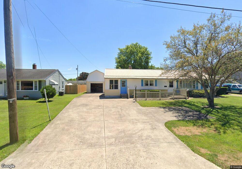
1021 Summit Dr Ashland, OH 44805
Estimated Value: $198,000 - $226,000
2
Beds
1
Bath
1,344
Sq Ft
$156/Sq Ft
Est. Value
About This Home
This home is located at 1021 Summit Dr, Ashland, OH 44805 and is currently estimated at $209,906, approximately $156 per square foot. 1021 Summit Dr is a home located in Ashland County with nearby schools including Ashland High School, Ashland County Community Academy, and Ashland Christian Elementary School.
Ownership History
Date
Name
Owned For
Owner Type
Purchase Details
Closed on
Aug 23, 2018
Bought by
Briggs Larry I and Bowen Melinda L
Current Estimated Value
Home Financials for this Owner
Home Financials are based on the most recent Mortgage that was taken out on this home.
Original Mortgage
$15,579
Outstanding Balance
$13,153
Interest Rate
1.03%
Mortgage Type
New Conventional
Estimated Equity
$196,753
Purchase Details
Closed on
Jul 21, 2000
Sold by
Norris Francis S
Bought by
Briggs Larry I
Purchase Details
Closed on
Jul 23, 1991
Bought by
Norris Francis S
Create a Home Valuation Report for This Property
The Home Valuation Report is an in-depth analysis detailing your home's value as well as a comparison with similar homes in the area
Home Values in the Area
Average Home Value in this Area
Purchase History
| Date | Buyer | Sale Price | Title Company |
|---|---|---|---|
| Briggs Larry I | $81,000 | -- | |
| Briggs Larry I | $81,000 | -- | |
| Norris Francis S | $52,000 | -- |
Source: Public Records
Mortgage History
| Date | Status | Borrower | Loan Amount |
|---|---|---|---|
| Open | Briggs Larry I | $15,579 |
Source: Public Records
Tax History
| Year | Tax Paid | Tax Assessment Tax Assessment Total Assessment is a certain percentage of the fair market value that is determined by local assessors to be the total taxable value of land and additions on the property. | Land | Improvement |
|---|---|---|---|---|
| 2025 | $1,746 | $50,560 | $11,550 | $39,010 |
| 2024 | $1,746 | $50,560 | $11,550 | $39,010 |
| 2023 | $1,746 | $50,560 | $11,550 | $39,010 |
| 2022 | $1,598 | $36,640 | $8,370 | $28,270 |
| 2021 | $1,605 | $36,640 | $8,370 | $28,270 |
| 2020 | $1,519 | $36,640 | $8,370 | $28,270 |
| 2019 | $1,434 | $32,000 | $7,480 | $24,520 |
| 2018 | $1,446 | $32,000 | $7,480 | $24,520 |
| 2017 | $1,379 | $32,000 | $7,480 | $24,520 |
| 2016 | $1,379 | $29,090 | $6,800 | $22,290 |
| 2015 | $1,367 | $29,090 | $6,800 | $22,290 |
| 2013 | $1,539 | $32,260 | $6,780 | $25,480 |
Source: Public Records
Map
Nearby Homes
- 934 Summit Dr
- 857 Sandusky St
- 162 Arthur's Ct
- 1218 Myers Ave
- 416-418 Carroll St
- 1210 Cottage St
- 219 W Washington St
- 703 Grant St
- 711 Grant St
- 1499 Troy Rd
- 0 Claremont Ave
- 917 Union St
- 1471 Troy Rd
- 150 College Ave
- 1375 Edgewood Dr
- 102 E Liberty St
- 120 High St
- 410 E 9th St
- 870 King Ridge Dr
- 908 King Ridge Dr
- 1031 Summit Dr
- 1024 Summit Dr
- 1032 Summit Dr
- 1010 Summit Dr
- 1020 Overlook Dr
- 1014 Overlook Dr
- 1039 Summit Dr
- 1028 Overlook Dr
- 623 Indian Trail
- 1036 Overlook Dr
- 1044 Summit Dr
- 1047 Summit Dr
- 1000 Summit Dr
- 969 Summit Dr
- 1002 Overlook Dr
- 311 Plymouth Ln
- 968 Summit Dr
- 633 Indian Trail
- 966 Overlook Dr
- 1102 Summit Dr