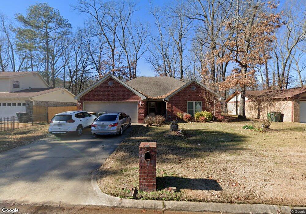
10222 Independence Ln Little Rock, AR 72209
Upper Baseline NeighborhoodEstimated Value: $148,000 - $184,000
--
Bed
2
Baths
1,519
Sq Ft
$108/Sq Ft
Est. Value
About This Home
This home is located at 10222 Independence Ln, Little Rock, AR 72209 and is currently estimated at $164,774, approximately $108 per square foot. 10222 Independence Ln is a home located in Pulaski County with nearby schools including Watson Elementary School, Cloverdale Middle School, and Little Rock Southwest High School.
Ownership History
Date
Name
Owned For
Owner Type
Purchase Details
Closed on
Feb 21, 2006
Sold by
Smith Jesse
Bought by
Welch Jennifer A
Current Estimated Value
Home Financials for this Owner
Home Financials are based on the most recent Mortgage that was taken out on this home.
Original Mortgage
$5,000
Interest Rate
6.1%
Mortgage Type
Stand Alone Second
Purchase Details
Closed on
Apr 20, 2005
Sold by
Ward William H and Ward Linda E
Bought by
Smith Jesse
Create a Home Valuation Report for This Property
The Home Valuation Report is an in-depth analysis detailing your home's value as well as a comparison with similar homes in the area
Home Values in the Area
Average Home Value in this Area
Purchase History
| Date | Buyer | Sale Price | Title Company |
|---|---|---|---|
| Welch Jennifer A | $124,000 | Standard Abstract & Title Co | |
| Smith Jesse | $5,000 | -- |
Source: Public Records
Mortgage History
| Date | Status | Borrower | Loan Amount |
|---|---|---|---|
| Closed | Welch Jennifer A | $5,000 | |
| Open | Welch Jennifer A | $119,800 |
Source: Public Records
Tax History Compared to Growth
Tax History
| Year | Tax Paid | Tax Assessment Tax Assessment Total Assessment is a certain percentage of the fair market value that is determined by local assessors to be the total taxable value of land and additions on the property. | Land | Improvement |
|---|---|---|---|---|
| 2025 | $1,860 | $34,035 | $3,000 | $31,035 |
| 2024 | $1,705 | $34,035 | $3,000 | $31,035 |
| 2023 | $1,705 | $34,035 | $3,000 | $31,035 |
| 2022 | $1,627 | $34,035 | $3,000 | $31,035 |
| 2021 | $1,560 | $22,130 | $4,300 | $17,830 |
| 2020 | $1,174 | $22,130 | $4,300 | $17,830 |
| 2019 | $1,174 | $22,130 | $4,300 | $17,830 |
| 2018 | $1,199 | $22,130 | $4,300 | $17,830 |
| 2017 | $1,199 | $22,130 | $4,300 | $17,830 |
| 2016 | $1,663 | $23,760 | $3,000 | $20,760 |
| 2015 | $1,666 | $23,760 | $3,000 | $20,760 |
| 2014 | $1,666 | $23,760 | $3,000 | $20,760 |
Source: Public Records
Map
Nearby Homes
- 10407 Republic Ln
- 5817 Drexel Ave
- 5823 Liberty Cove
- 22 Old Glory Ct
- 00 Lovett Dr
- 5300 Southboro Ct
- 000 Geyer Springs Rd
- 6711 Woodfield Rd
- 10001 Warren Dr
- 6313 Senate Dr
- 6611 Fairfield Dr
- 9220 Reck Rd
- 8616 Dreher Ln
- 3938 Wooddale Dr
- 8600 Dreher Ln
- 9901 Eva Ln
- 4028 Arapaho Trail
- 0000 Eva Ln
- 8511 Dreher Ln
- 7101 Redwood Dr
- 10300 Independence Ln
- 10216 Independence Ln
- 10306 Independence Ln
- 10223 Republic Ln
- 10210 Independence Ln
- 10215 Republic Ln
- 10301 Republic Ln
- 10211 Republic Ln
- 10223 Independence Ln
- 10312 Independence Ln
- 10301 Independence Ln
- 10215 Independence Ln
- 10204 Independence Ln
- 10307 Republic Ln
- 10207 Republic Ln
- 10209 Independence Ln
- 10307 Independence Ln
- 10311 Republic Ln
- 10318 Independence Ln
- 10203 Republic Ln