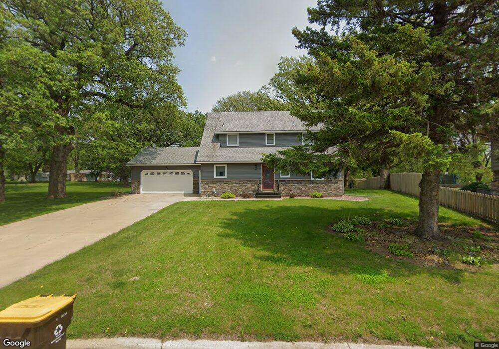
1023 Capitol Heights Ct Fairmont, MN 56031
Estimated Value: $214,000 - $347,000
3
Beds
2
Baths
1,724
Sq Ft
$156/Sq Ft
Est. Value
About This Home
This home is located at 1023 Capitol Heights Ct, Fairmont, MN 56031 and is currently estimated at $269,140, approximately $156 per square foot. 1023 Capitol Heights Ct is a home located in Martin County with nearby schools including Fairmont Elementary School, Fairmont Junior/Senior High School, and St. John Vianney School.
Ownership History
Date
Name
Owned For
Owner Type
Purchase Details
Closed on
Aug 18, 2005
Sold by
Lewis Sylvia A
Bought by
Redenius Jill
Current Estimated Value
Home Financials for this Owner
Home Financials are based on the most recent Mortgage that was taken out on this home.
Original Mortgage
$135,000
Interest Rate
5.93%
Mortgage Type
Purchase Money Mortgage
Create a Home Valuation Report for This Property
The Home Valuation Report is an in-depth analysis detailing your home's value as well as a comparison with similar homes in the area
Home Values in the Area
Average Home Value in this Area
Purchase History
| Date | Buyer | Sale Price | Title Company |
|---|---|---|---|
| Redenius Jill | $155,000 | None Available |
Source: Public Records
Mortgage History
| Date | Status | Borrower | Loan Amount |
|---|---|---|---|
| Previous Owner | Redenius Jill | $135,000 |
Source: Public Records
Tax History Compared to Growth
Tax History
| Year | Tax Paid | Tax Assessment Tax Assessment Total Assessment is a certain percentage of the fair market value that is determined by local assessors to be the total taxable value of land and additions on the property. | Land | Improvement |
|---|---|---|---|---|
| 2025 | $2,902 | $232,800 | $42,800 | $190,000 |
| 2024 | $3,110 | $232,800 | $42,800 | $190,000 |
| 2023 | $3,090 | $252,300 | $39,100 | $213,200 |
| 2022 | $2,564 | $235,400 | $39,800 | $195,600 |
| 2021 | $2,014 | $188,600 | $29,600 | $159,000 |
| 2020 | $1,956 | $159,800 | $29,600 | $130,200 |
| 2019 | $1,700 | $150,400 | $27,900 | $122,500 |
| 2018 | $1,898 | $145,700 | $27,000 | $118,700 |
| 2017 | $1,626 | $111,200 | $20,574 | $90,626 |
| 2016 | $1,534 | $108,700 | $20,133 | $88,567 |
| 2015 | $1,325 | $107,200 | $19,498 | $87,702 |
| 2013 | $1,547 | $107,200 | $19,498 | $87,702 |
Source: Public Records
Map
Nearby Homes
- 1700 Knollwood Dr
- 1640 Patriot Dr
- 767 Shoreacres Dr
- 1365 Oak Beach Dr
- 1334 Oak Beach Dr
- 1317 Beach Place
- 1910 Knollwood Dr
- 1600 S Prairie Ave
- 2413 Albion Ave
- 2107 Stade Ln
- 2224 Red Bird Ln
- 1312 S State St
- 2218 Red Bird Ln
- 2214 Red Bird Ln
- 944 S Hampton St
- 123 Linden Ave
- 1001 S Orient St
- 501 S Fairlakes Ave
- 841 Redwood Dr
- 915 S Hampton St
- 1025 Capitol Heights Ct
- 517 Independence Dr
- 520 Rona Ct
- 511 Independence Dr
- 515 Rona Ct
- 1027 Capitol Heights Ct
- 518 Rona Ct
- 1026 Capitol Heights Ct
- 505 Independence Dr
- 451 W Lair Rd
- 451 451 Lair-Road-
- 412 W Lair Rd
- 1029 1029 Capitol Heights Ct
- 509 Rona Ct
- 1029 Capitol Heights Ct
- 410 W Lair Rd
- 508 Rona Ct
- 1030 Shoreacres Dr
- 972 Liberty Ln
- 1028 Capitol Heights Ct